| Memorials | : | 0 |
| Location | : | Hayton, Allerdale Borough, England |
| Coordinate | : | 54.7625930, -3.3880000 |
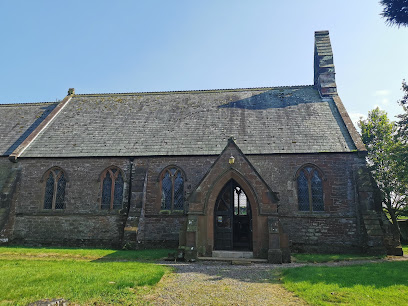
| Description | : | St James Church, Hayton, Cumbria is an active Anglican parish church in the deanery of Solway, the archdeaconry of West Cumberland and the diocese of Carlisle.[1] The church dates from the 19th century. The village of Hayton, Cumbria lies two miles southwest of the town of Aspatria and half a mile northwest of Prospect, and is signposted from the A596 road. The church sits in the centre of the village, on the south side of the village green. |
frequently asked questions (FAQ):
-
Where is St James Churchyard?
St James Churchyard is located at Hayton, Allerdale, Cumbria Hayton, Allerdale Borough ,Cumbria ,England.
-
St James Churchyard cemetery's updated grave count on graveviews.com?
0 memorials
-
Where are the coordinates of the St James Churchyard?
Latitude: 54.7625930
Longitude: -3.3880000
Nearby Cemetories:
1. Christ Churchyard
Allonby, Allerdale Borough, England
Coordinate: 54.7671880, -3.4309950
2. Quaker Burial Ground
Allonby, Allerdale Borough, England
Coordinate: 54.7790680, -3.4296924
3. St. Mary's Churchyard
Gilcrux, Allerdale Borough, England
Coordinate: 54.7307810, -3.3722050
4. St Matthew’s Churchyard
Westnewton, Allerdale Borough, England
Coordinate: 54.7848970, -3.3455930
5. St. Kentigern Churchyard
Aspatria, Allerdale Borough, England
Coordinate: 54.7648630, -3.3270680
6. St Cuthbert Churchyard
Plumbland, Allerdale Borough, England
Coordinate: 54.7405890, -3.3350880
7. St John the Evangelist Churchyard
Crosscanonby, Allerdale Borough, England
Coordinate: 54.7373530, -3.4471990
8. Holme St Cuthbert Churchyard
Holme St Cuthbert, Allerdale Borough, England
Coordinate: 54.8108780, -3.3951990
9. St Mungo Churchyard
Dearham, Allerdale Borough, England
Coordinate: 54.7139630, -3.4412770
10. Dearham Cemetery
Dearham, Allerdale Borough, England
Coordinate: 54.7102360, -3.4374800
11. Maryport Cemetery
Maryport, Allerdale Borough, England
Coordinate: 54.7294530, -3.4754560
12. Quaker Burial Ground
Beckfoot, Copeland Borough, England
Coordinate: 54.8330850, -3.4134130
13. St. Bridget's Church Cemetery
Bridekirk, Allerdale Borough, England
Coordinate: 54.6905620, -3.3715490
14. St. Mungo Churchyard
Bromfield, Allerdale Borough, England
Coordinate: 54.8109800, -3.2838200
15. St Mary's Churchyard
Maryport, Allerdale Borough, England
Coordinate: 54.7153300, -3.4947700
16. Friends Burying Ground
Maryport, Allerdale Borough, England
Coordinate: 54.7183000, -3.4993000
17. All Saints Churchyard
Mealsgate, Allerdale Borough, England
Coordinate: 54.7709800, -3.2493310
18. Old All Hallows Churchyard
Mealsgate, Allerdale Borough, England
Coordinate: 54.7651800, -3.2390300
19. St Columba Churchyard
Broughton Moor, Allerdale Borough, England
Coordinate: 54.6866710, -3.4696330
20. St Michael and All Angels Churchyard
Torpenhow, Allerdale Borough, England
Coordinate: 54.7468720, -3.2354350
21. St Michael & All Angels Churchyard
Bewaldeth, Allerdale Borough, England
Coordinate: 54.6879000, -3.3009000
22. Christ Churchyard
Great Broughton, Allerdale Borough, England
Coordinate: 54.6713960, -3.4356630
23. Saint Bridgets Churchyard
Brigham, Allerdale Borough, England
Coordinate: 54.6648910, -3.4193640
24. Brigham Cemetery
Brigham, Allerdale Borough, England
Coordinate: 54.6643900, -3.4186090

