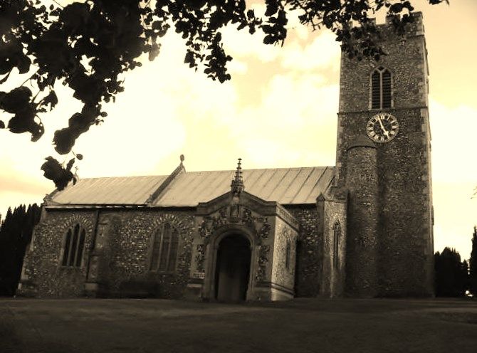
| Memorials | : | 6 |
| Location | : | Letheringsett, North Norfolk District, England |
| Website | : | www.norfolkchurches.co.uk/glandford/glandford.htm |
| Coordinate | : | 52.9311970, 1.0396308 |
| Description | : | Formerly in ruins, reopened 1882 for burials after being closed for 150 years, restored 1899 to 1908. Old church had chancel, nave, north aisle, north porch. Arcade is restored Perpendicular, chancel now has hammerbeam roof, panelling, traceried screens, stained glass by Kempe and Bryans (also in north aisle). Font is copy of Walsoken. Chalice and paten, salver, Birmingham 1774. Large monument by Bazzanti of Florence. E. Rose (NAU). Part of the elaborate carved woodwork from the restoration depicts the carvers; another pew end is a copy of The Shepherd's Chief Mourner, for which the model was Sir Alfred Jodrell's dog. The silver collection plate is... Read More |
frequently asked questions (FAQ):
-
Where is St. Martin's Churchyard, Glandford?
St. Martin's Churchyard, Glandford is located at Letheringsett, North Norfolk District ,Norfolk , NR25 7JPEngland.
-
St. Martin's Churchyard, Glandford cemetery's updated grave count on graveviews.com?
6 memorials
-
Where are the coordinates of the St. Martin's Churchyard, Glandford?
Latitude: 52.9311970
Longitude: 1.0396308
Nearby Cemetories:
1. St Margaret Churchyard
Cley, North Norfolk District, England
Coordinate: 52.9463890, 1.0475480
2. St. Nicholas' Churchyard
Blakeney, North Norfolk District, England
Coordinate: 52.9512300, 1.0247250
3. St. Margaret's Churchyard
Saxlingham, North Norfolk District, England
Coordinate: 52.9155250, 1.0121410
4. Carmelite Friary of the Blessed Virgin
Blakeney, North Norfolk District, England
Coordinate: 52.9553240, 1.0234250
5. St. Andrews Churchyard
Letheringsett, North Norfolk District, England
Coordinate: 52.9081600, 1.0623490
6. St Andrew and St Mary Churchyard
Langham, North Norfolk District, England
Coordinate: 52.9310020, 0.9855430
7. Holt Town Cemetery
Holt, North Norfolk District, England
Coordinate: 52.9117900, 1.0850400
8. St Nicholas Churchyard
Salthouse, North Norfolk District, England
Coordinate: 52.9503200, 1.0889800
9. Methodist Memorial Gardens
Holt, North Norfolk District, England
Coordinate: 52.9067730, 1.0878360
10. All Saints Churchyard
Morston, North Norfolk District, England
Coordinate: 52.9543600, 0.9886660
11. Saint Andrew's Churchyard
Field Dalling, North Norfolk District, England
Coordinate: 52.9110600, 0.9832800
12. St. Mary the Virgin Churchyard
Kelling, North Norfolk District, England
Coordinate: 52.9322300, 1.1053700
13. Saint Andrew the Apostle
Holt, North Norfolk District, England
Coordinate: 52.9063400, 1.0933500
14. St. Andrew's Churchyard
Brinton, North Norfolk District, England
Coordinate: 52.8803690, 1.0274610
15. All Saints Churchyard
Bale, North Norfolk District, England
Coordinate: 52.8906290, 0.9871950
16. St Lawrence Churchyard
Hunworth, North Norfolk District, England
Coordinate: 52.8772530, 1.0673080
17. All Saints Churchyard
Cockthorpe, North Norfolk District, England
Coordinate: 52.9407830, 0.9472385
18. Binham Priory
Binham, North Norfolk District, England
Coordinate: 52.9199700, 0.9452300
19. St Mary Churchyard
Gunthorpe, North Norfolk District, England
Coordinate: 52.8767720, 0.9883020
20. St Maurice Churchyard
Briningham, North Norfolk District, England
Coordinate: 52.8682680, 1.0271340
21. St Andrew Churchyard
Hempstead, North Norfolk District, England
Coordinate: 52.8895750, 1.1270070
22. All Saints Churchyard
Hempstead, North Norfolk District, England
Coordinate: 52.8895200, 1.1274620
23. St. Martin's Churchyard
Hindringham, North Norfolk District, England
Coordinate: 52.8882000, 0.9477300
24. St Mary Churchyard Burgh Parva
Melton Constable, North Norfolk District, England
Coordinate: 52.8605700, 1.0337300

