
| Memorials | : | 0 |
| Location | : | Weston Colville, South Cambridgeshire District, England |
| Coordinate | : | 52.1530000, 0.3620000 |
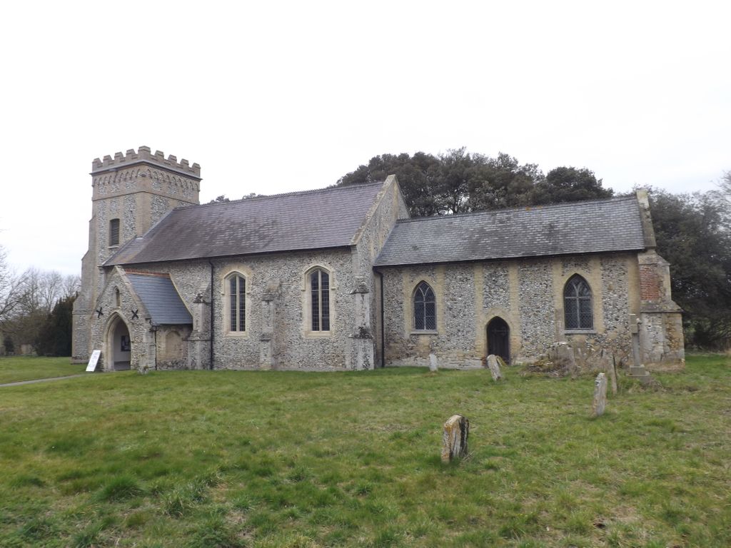
| Description | : | The parish church of St Mary consists of a chancel with north vestry, nave with south porch, and west tower. The nave dates from the 14th century, with the tower added in the 15th century. The external stone dressings were mainly replaced by grey brick in the 1820s |
frequently asked questions (FAQ):
-
Where is St Mary's Churchyard?
St Mary's Churchyard is located at Weston Colville, South Cambridgeshire District ,Cambridgeshire ,England.
-
St Mary's Churchyard cemetery's updated grave count on graveviews.com?
0 memorials
-
Where are the coordinates of the St Mary's Churchyard?
Latitude: 52.1530000
Longitude: 0.3620000
Nearby Cemetories:
1. St Andrew's Church
West Wratting, South Cambridgeshire District, England
Coordinate: 52.1461000, 0.3456200
2. St Peter Churchyard
Carlton, South Cambridgeshire District, England
Coordinate: 52.1505470, 0.3982180
3. St Mary the Less Churchyard
Westley Waterless, East Cambridgeshire District, England
Coordinate: 52.1805000, 0.3650000
4. St Augustine of Canterbury Churchyard
Burrough Green, East Cambridgeshire District, England
Coordinate: 52.1700000, 0.4000000
5. St. Mary the Virgin Churchyard
Dullingham, East Cambridgeshire District, England
Coordinate: 52.1934500, 0.3850600
6. St. George's Churchyard
Six Mile Bottom, South Cambridgeshire District, England
Coordinate: 52.1861900, 0.3117400
7. All Saints Churchyard
Horseheath, South Cambridgeshire District, England
Coordinate: 52.1018130, 0.3547390
8. St Mary the Virgin Churchyard
Great Bradley, St Edmundsbury Borough, England
Coordinate: 52.1516228, 0.4457830
9. St Mary the Virgin Churchyard
Withersfield, St Edmundsbury Borough, England
Coordinate: 52.1030300, 0.4095000
10. All Saints Churchyard
Little Bradley, St Edmundsbury Borough, England
Coordinate: 52.1417700, 0.4562500
11. St Peter Churchyard
Little Thurlow, St Edmundsbury Borough, England
Coordinate: 52.1335150, 0.4527380
12. Chapel House Graveyard
Great Thurlow, St Edmundsbury Borough, England
Coordinate: 52.1292493, 0.4502808
13. All Saints Churchyard
Great Thurlow, St Edmundsbury Borough, England
Coordinate: 52.1259500, 0.4538200
14. Wood Ditton Cemetery
Woodditton, East Cambridgeshire District, England
Coordinate: 52.2056250, 0.4273720
15. Linton Cemetery
Linton, South Cambridgeshire District, England
Coordinate: 52.0991100, 0.2809500
16. National Stud Equine Cemetery
Newmarket, Forest Heath District, England
Coordinate: 52.2272000, 0.3644800
17. St Nicholas Churchyard
Great Wilbraham, South Cambridgeshire District, England
Coordinate: 52.1963890, 0.2638060
18. All Saints Churchyard
Kirtling, East Cambridgeshire District, England
Coordinate: 52.1909900, 0.4663280
19. Holy Trinity Churchyard
Hildersham, South Cambridgeshire District, England
Coordinate: 52.1162000, 0.2556000
20. St Mary the Virgin Churchyard
Linton, South Cambridgeshire District, England
Coordinate: 52.0963790, 0.2784350
21. Linton Free Church
Linton, South Cambridgeshire District, England
Coordinate: 52.0961850, 0.2764610
22. St. Mary's Churchyard
Great Wratting, St Edmundsbury Borough, England
Coordinate: 52.1063290, 0.4636470
23. Haverhill Cemetery
Haverhill, St Edmundsbury Borough, England
Coordinate: 52.0867860, 0.4336830
24. St. Mary's Churchyard
Little Wratting, St Edmundsbury Borough, England
Coordinate: 52.1013310, 0.4666450