
| Memorials | : | 20 |
| Location | : | Itteringham, North Norfolk District, England |
| Coordinate | : | 52.8334650, 1.1826370 |
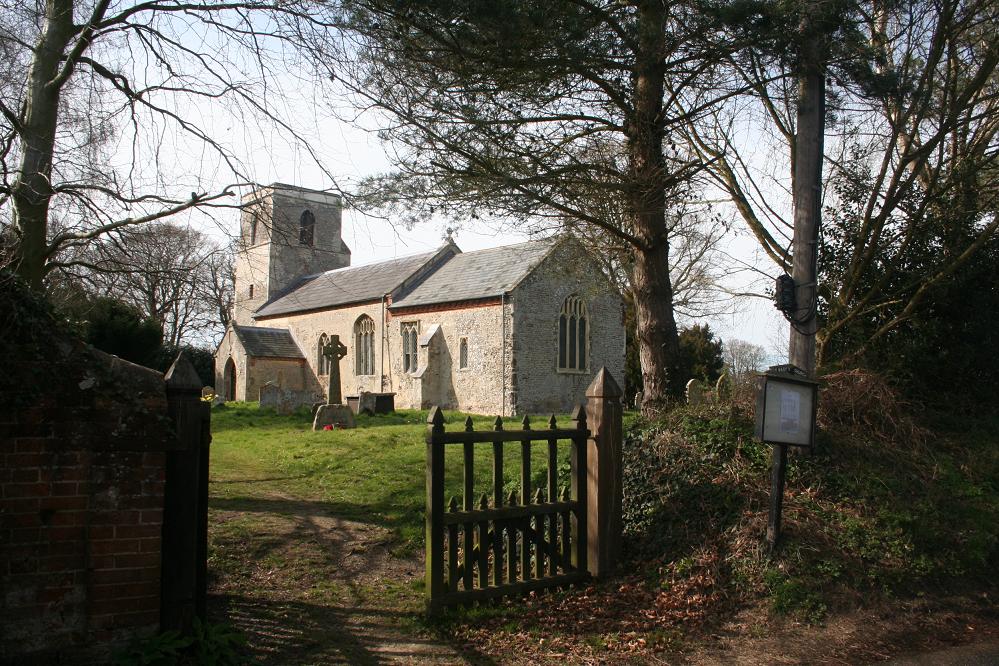
| Description | : | Parish church, medieval, restored 1859. Flint with slate roof of 1824. Tower, nave, chancel, south porch and ruined north chapel. Exterior: unbuttressed west tower of 3 stages in coursed flint with stone dressings; plain parapet; south side gargoyle; projecting stair turret to north side. 2-centred west window arch with central wooden mullion; wide bell openings with multi-cusped heads. Tablet on south wall to William Load, 1734, and wife Grace, 1739. Nave: rendered coursed flint with some iron conglomerate; eaves rebuilt in brick. 2 C19 south windows of 2 and 3 lights. South porch: rendered flint with stone dressings partly rebuilt... Read More |
frequently asked questions (FAQ):
-
Where is St Mary Churchyard?
St Mary Churchyard is located at 7 Church Road Itteringham, North Norfolk District ,Norfolk , NR11 7AYEngland.
-
St Mary Churchyard cemetery's updated grave count on graveviews.com?
20 memorials
-
Where are the coordinates of the St Mary Churchyard?
Latitude: 52.8334650
Longitude: 1.1826370
Nearby Cemetories:
1. St Mary's Church
Mannington, North Norfolk District, England
Coordinate: 52.8418580, 1.1786460
2. St. Andrew’s Churchyard
Little Barningham, North Norfolk District, England
Coordinate: 52.8547270, 1.1795150
3. St. Peter & St. Paul's Churchyard
Oulton, Broadland District, England
Coordinate: 52.8114317, 1.1685485
4. St. Andrew's Churchyard
Saxthorpe, North Norfolk District, England
Coordinate: 52.8299250, 1.1398600
5. St. Peter's Churchyard
Corpusty, North Norfolk District, England
Coordinate: 52.8207280, 1.1371910
6. Our Lady and St. Margaret's Churchyard
Calthorpe, North Norfolk District, England
Coordinate: 52.8391540, 1.2373828
7. St. Peter's Churchyard
Matlaske, North Norfolk District, England
Coordinate: 52.8683511, 1.1946365
8. St. Michael's Churchyard
Plumstead, North Norfolk District, England
Coordinate: 52.8691700, 1.1669320
9. Blickling Hall
Blickling, Broadland District, England
Coordinate: 52.8095474, 1.2310860
10. St Andrew Churchyard
Blickling, Broadland District, England
Coordinate: 52.8095370, 1.2311760
11. Silvergate Lane Cemetery
Blickling, Broadland District, England
Coordinate: 52.8075334, 1.2305140
12. St. Mary's Churchyard
Aldborough, North Norfolk District, England
Coordinate: 52.8575340, 1.2354660
13. St. Peter and St. Paul's Churchyard
Heydon, Broadland District, England
Coordinate: 52.8027280, 1.1345020
14. St. Mary's Churchyard
Barningham, North Norfolk District, England
Coordinate: 52.8757410, 1.1882470
15. All Saints Churchyard
Alby with Thwaite, North Norfolk District, England
Coordinate: 52.8533000, 1.2555000
16. St. Mary's Churchyard
Erpingham, North Norfolk District, England
Coordinate: 52.8338580, 1.2626100
17. St. Peter and St. Paul's Churchyard
Edgefield, North Norfolk District, England
Coordinate: 52.8645320, 1.1089840
18. Saint Mary's Churchyard
Baconsthorpe, North Norfolk District, England
Coordinate: 52.8872500, 1.1606900
19. St. Michael and All Angels Churchyard
Aylsham, Broadland District, England
Coordinate: 52.7960690, 1.2506530
20. St. Peter's Churchyard
North Barningham, North Norfolk District, England
Coordinate: 52.8888040, 1.1954330
21. St. Ethelbert's Church Burial Ground
Alby with Thwaite, North Norfolk District, England
Coordinate: 52.8548760, 1.2701850
22. St. Mary's Churchyard
Bessingham, North Norfolk District, England
Coordinate: 52.8871980, 1.2193150
23. St. Andrew's Churchyard
Wood Dalling, Broadland District, England
Coordinate: 52.8001170, 1.0985350
24. Edgefield Old Churchyard
Edgefield, North Norfolk District, England
Coordinate: 52.8687300, 1.1001800