
| Memorials | : | 0 |
| Location | : | Layer Breton, Colchester Borough, England |
| Coordinate | : | 51.8190300, 0.8269200 |
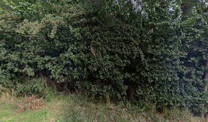
| Description | : | Layer Breton is a village and a civil parish in Essex, England. This relates to the original church/churchyard, which suffered damage in the 1884 Colchester earthquake, and not to the new church at Layer Breton Heath [Postal Code: CO2 0LZ] which has no burial ground and which was built in brick in 1923 on a new site nearly a mile north of the old one. The GPS for the new church are Latitude: 51.83140, Longitude: 0.82078. No traces of the original church could be found in July 2016; the area is a much-overgrown thicket and accessed with great difficulty. |
frequently asked questions (FAQ):
-
Where is St Mary the Virgin Churchyard?
St Mary the Virgin Churchyard is located at Layer Breton, Colchester Borough ,Essex ,England.
-
St Mary the Virgin Churchyard cemetery's updated grave count on graveviews.com?
0 memorials
-
Where are the coordinates of the St Mary the Virgin Churchyard?
Latitude: 51.8190300
Longitude: 0.8269200
Nearby Cemetories:
1. St Mary the Virgin Church
Layer Marney, Colchester Borough, England
Coordinate: 51.8221000, 0.7965000
2. St Mary the Virgin Churchyard
Layer Marney, Colchester Borough, England
Coordinate: 51.8221070, 0.7964060
3. St Stephen the Martyr Churchyard
Great Wigborough, Colchester Borough, England
Coordinate: 51.8047840, 0.8530500
4. St John the Baptist Churchyard
Layer de la Haye, Colchester Borough, England
Coordinate: 51.8361820, 0.8505660
5. St Peter and St Paul Churchyard
Birch, Colchester Borough, England
Coordinate: 51.8442460, 0.8202570
6. St Mary the Virgin, Virley
Salcott, Colchester Borough, England
Coordinate: 51.7881166, 0.8251898
7. St Mary the Virgin, Salcott
Salcott, Colchester Borough, England
Coordinate: 51.7866798, 0.8303322
8. St Mary The Virgin Churchyard
Peldon, Colchester Borough, England
Coordinate: 51.8141000, 0.8852800
9. St Nicholas Churchyard
Little Wigborough, Colchester Borough, England
Coordinate: 51.7944230, 0.8712110
10. United Reformed Churchyard
Tiptree, Colchester Borough, England
Coordinate: 51.8109600, 0.7590600
11. St Andrew Churchyard
Abberton, Colchester Borough, England
Coordinate: 51.8373460, 0.8978390
12. All Saints Churchyard
Messing, Colchester Borough, England
Coordinate: 51.8364416, 0.7491859
13. St. Michael & All Angels Churchyard
Copford, Colchester Borough, England
Coordinate: 51.8693170, 0.8093620
14. St. Nicholas Churchyard
Tolleshunt D'Arcy, Maldon District, England
Coordinate: 51.7706870, 0.7932420
15. St Nicholas New Churchyard
Tolleshunt D'Arcy, Maldon District, England
Coordinate: 51.7693270, 0.7910210
16. All Saints Churchyard
Shrub End, Colchester Borough, England
Coordinate: 51.8722400, 0.8607000
17. St Michael's Churchyard
Berechurch, Colchester Borough, England
Coordinate: 51.8600000, 0.8926000
18. Tollesbury Cemetery
Tollesbury, Maldon District, England
Coordinate: 51.7586200, 0.8248200
19. St Mary the Virgin Churchyard
Tollesbury, Maldon District, England
Coordinate: 51.7578300, 0.8329100
20. All Saints Churchyard
Inworth, Colchester Borough, England
Coordinate: 51.8276200, 0.7257200
21. St Albright Churchyard
Stanway, Colchester Borough, England
Coordinate: 51.8830780, 0.8159380
22. St Nicholas Churchyard
Tolleshunt Major, Maldon District, England
Coordinate: 51.7660307, 0.7646916
23. Barfield Road Burial Ground
West Mersea, Colchester Borough, England
Coordinate: 51.7782400, 0.9144400
24. St Peter & St Paul Churchyard
West Mersea, Colchester Borough, England
Coordinate: 51.7750700, 0.9108780