
| Memorials | : | 0 |
| Location | : | Sheffield, Metropolitan Borough of Sheffield, England |
| Coordinate | : | 53.3798100, -1.4697300 |
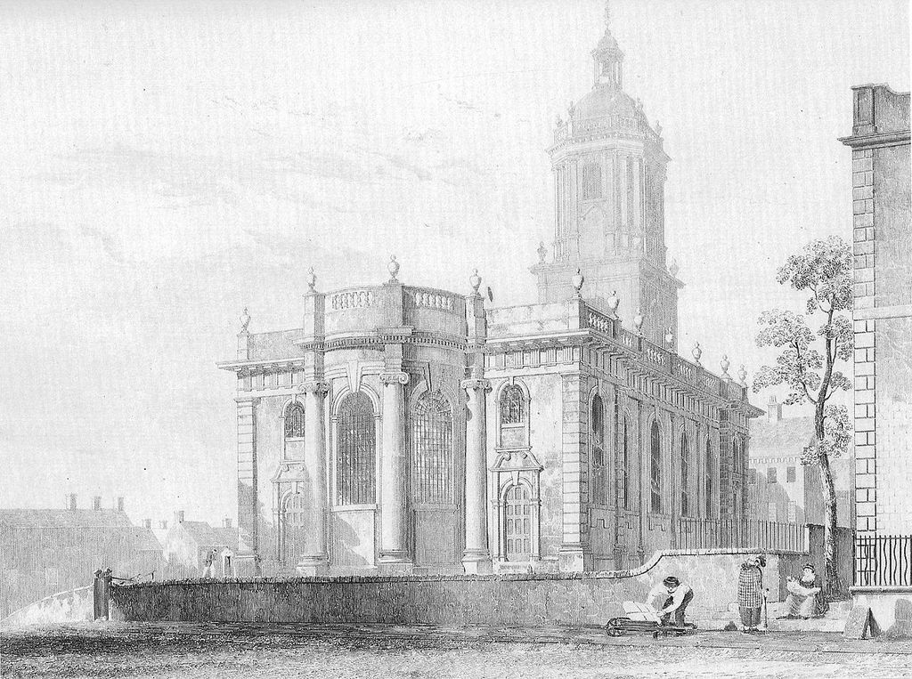
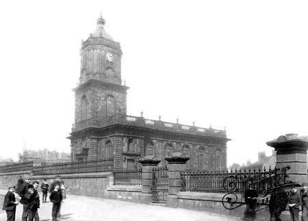
| Description | : | St Paul's Church, Sheffield, was a chapel of ease to Sheffield Parish Church. By 1700, Sheffield's population had reached 5,000, and a second Anglican place of worship was required to house a growing congregation. A site on the southern edge of the town was selected, facing on to Pinstone Lane (later redeveloped as Pinstone Street). A public subscription was raised, and St Paul's was largely completed by 1721. The church was built in the Baroque style, with the street frontage dominated by an Italianate tower. The chapel had seating for 1,200 people. Map of Sheffield in 1736. St Paul's is numbered "2",... Read More |
frequently asked questions (FAQ):
-
Where is St. Paul's Churchyard?
St. Paul's Churchyard is located at Pinstone St Sheffield, Metropolitan Borough of Sheffield ,South Yorkshire ,England.
-
St. Paul's Churchyard cemetery's updated grave count on graveviews.com?
0 memorials
-
Where are the coordinates of the St. Paul's Churchyard?
Latitude: 53.3798100
Longitude: -1.4697300
Nearby Cemetories:
1. Upper Chapel Courtyard
Sheffield, Metropolitan Borough of Sheffield, England
Coordinate: 53.3809000, -1.4682480
2. Cathedral Church of Saint Marie
Sheffield, Metropolitan Borough of Sheffield, England
Coordinate: 53.3811700, -1.4679400
3. Former Methodist Chapel Churchyard
Sheffield, Metropolitan Borough of Sheffield, England
Coordinate: 53.3810100, -1.4744400
4. Sheffield Cathedral
Sheffield, Metropolitan Borough of Sheffield, England
Coordinate: 53.3831040, -1.4692000
5. Bowden Street Cemetery
Sheffield, Metropolitan Borough of Sheffield, England
Coordinate: 53.3766670, -1.4763630
6. Saint George's Churchyard
Sheffield, Metropolitan Borough of Sheffield, England
Coordinate: 53.3817960, -1.4807190
7. St Mary Churchyard
Sheffield, Metropolitan Borough of Sheffield, England
Coordinate: 53.3724810, -1.4716300
8. Cholera Monument
Sheffield, Metropolitan Borough of Sheffield, England
Coordinate: 53.3761350, -1.4580820
9. Saint Johns Church Park Churchyard
Sheffield, Metropolitan Borough of Sheffield, England
Coordinate: 53.3839792, -1.4538831
10. St. Philip's Churchyard
Sheffield, Metropolitan Borough of Sheffield, England
Coordinate: 53.3898180, -1.4789820
11. Sheffield General Cemetery
Sheffield, Metropolitan Borough of Sheffield, England
Coordinate: 53.3691670, -1.4872220
12. Christ Church Pitsmoor
Sheffield, Metropolitan Borough of Sheffield, England
Coordinate: 53.3969748, -1.4673422
13. Burngreave Cemetery
Sheffield, Metropolitan Borough of Sheffield, England
Coordinate: 53.3969000, -1.4615000
14. Christ Church
Heeley, Metropolitan Borough of Sheffield, England
Coordinate: 53.3604900, -1.4678980
15. City Road Cemetery and Crematorium
Sheffield, Metropolitan Borough of Sheffield, England
Coordinate: 53.3694760, -1.4406940
16. The Well Sheffield Baptist Church
Sheffield, Metropolitan Borough of Sheffield, England
Coordinate: 53.3684415, -1.4989121
17. St Thomas Churchyard
Sheffield, Metropolitan Borough of Sheffield, England
Coordinate: 53.3822200, -1.5072200
18. Zion Graveyard
Attercliffe, Metropolitan Borough of Sheffield, England
Coordinate: 53.3944160, -1.4326430
19. Hillsborough Barracks Chapel Courtyard
Hillsborough, Metropolitan Borough of Sheffield, England
Coordinate: 53.4013100, -1.4980900
20. Attercliffe Municipal Cemetery
Attercliffe, Metropolitan Borough of Sheffield, England
Coordinate: 53.3957050, -1.4317500
21. Christ Church Churchyard
Attercliffe, Metropolitan Borough of Sheffield, England
Coordinate: 53.3952000, -1.4307000
22. Christ Church Cemetery Attercliffe
Attercliffe, Metropolitan Borough of Sheffield, England
Coordinate: 53.3955262, -1.4309578
23. Crookes Cemetery
Sheffield, Metropolitan Borough of Sheffield, England
Coordinate: 53.3816730, -1.5168480
24. St Mary Churchyard
Walkley, Metropolitan Borough of Sheffield, England
Coordinate: 53.3907127, -1.5148580