
| Memorials | : | 0 |
| Location | : | Sheffield, Metropolitan Borough of Sheffield, England |
| Coordinate | : | 53.3898180, -1.4789820 |
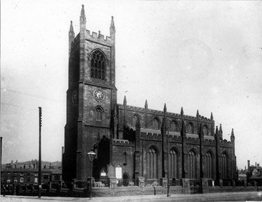
| Description | : | The Church of St Philip was built between Infirmary Road and Penistone Road, its first Stone was laid on September 26th 1822 by Mr Philip Gell and it was consecrated on July 2nd 2828 by Archbishop Vernon Harcourt. The churchyard closed for burials in 1857. The Rev. John Livesey anticipated the closure and obtained five acres of ground at Wardsend for a new burial ground which was consecrated on July 5th 1859. In 1901 the Cemetery was enlarged by the addition of a further two acres. It would seem that although appearing in the St Philip's burial... Read More |
frequently asked questions (FAQ):
-
Where is St. Philip's Churchyard?
St. Philip's Churchyard is located at Sheffield, Metropolitan Borough of Sheffield ,South Yorkshire ,England.
-
St. Philip's Churchyard cemetery's updated grave count on graveviews.com?
0 memorials
-
Where are the coordinates of the St. Philip's Churchyard?
Latitude: 53.3898180
Longitude: -1.4789820
Nearby Cemetories:
1. Saint George's Churchyard
Sheffield, Metropolitan Borough of Sheffield, England
Coordinate: 53.3817960, -1.4807190
2. Sheffield Cathedral
Sheffield, Metropolitan Borough of Sheffield, England
Coordinate: 53.3831040, -1.4692000
3. Former Methodist Chapel Churchyard
Sheffield, Metropolitan Borough of Sheffield, England
Coordinate: 53.3810100, -1.4744400
4. Christ Church Pitsmoor
Sheffield, Metropolitan Borough of Sheffield, England
Coordinate: 53.3969748, -1.4673422
5. Cathedral Church of Saint Marie
Sheffield, Metropolitan Borough of Sheffield, England
Coordinate: 53.3811700, -1.4679400
6. Upper Chapel Courtyard
Sheffield, Metropolitan Borough of Sheffield, England
Coordinate: 53.3809000, -1.4682480
7. St. Paul's Churchyard
Sheffield, Metropolitan Borough of Sheffield, England
Coordinate: 53.3798100, -1.4697300
8. Burngreave Cemetery
Sheffield, Metropolitan Borough of Sheffield, England
Coordinate: 53.3969000, -1.4615000
9. Bowden Street Cemetery
Sheffield, Metropolitan Borough of Sheffield, England
Coordinate: 53.3766670, -1.4763630
10. Saint Johns Church Park Churchyard
Sheffield, Metropolitan Borough of Sheffield, England
Coordinate: 53.3839792, -1.4538831
11. Hillsborough Barracks Chapel Courtyard
Hillsborough, Metropolitan Borough of Sheffield, England
Coordinate: 53.4013100, -1.4980900
12. St Mary Churchyard
Sheffield, Metropolitan Borough of Sheffield, England
Coordinate: 53.3724810, -1.4716300
13. St Thomas Churchyard
Sheffield, Metropolitan Borough of Sheffield, England
Coordinate: 53.3822200, -1.5072200
14. Cholera Monument
Sheffield, Metropolitan Borough of Sheffield, England
Coordinate: 53.3761350, -1.4580820
15. Wardsend Cemetery
Sheffield, Metropolitan Borough of Sheffield, England
Coordinate: 53.4086120, -1.4895330
16. Sheffield General Cemetery
Sheffield, Metropolitan Borough of Sheffield, England
Coordinate: 53.3691670, -1.4872220
17. St Mary Churchyard
Walkley, Metropolitan Borough of Sheffield, England
Coordinate: 53.3907127, -1.5148580
18. Rivelin Jewish Cemetery
Sheffield, Metropolitan Borough of Sheffield, England
Coordinate: 53.3914480, -1.5149920
19. St Michael's Roman Catholic Cemetery
Sheffield, Metropolitan Borough of Sheffield, England
Coordinate: 53.3916300, -1.5162800
20. Hillsborough Walled Garden Memorials
Hillsborough, Metropolitan Borough of Sheffield, England
Coordinate: 53.4071221, -1.5039054
21. Crookes Cemetery
Sheffield, Metropolitan Borough of Sheffield, England
Coordinate: 53.3816730, -1.5168480
22. The Well Sheffield Baptist Church
Sheffield, Metropolitan Borough of Sheffield, England
Coordinate: 53.3684415, -1.4989121
23. Zion Graveyard
Attercliffe, Metropolitan Borough of Sheffield, England
Coordinate: 53.3944160, -1.4326430
24. Attercliffe Municipal Cemetery
Attercliffe, Metropolitan Borough of Sheffield, England
Coordinate: 53.3957050, -1.4317500