
| Memorials | : | 0 |
| Location | : | Camerton, Allerdale Borough, England |
| Website | : | co-curate.ncl.ac.uk/church-of-st-peter-camerton/ |
| Coordinate | : | 54.6562240, -3.4969760 |
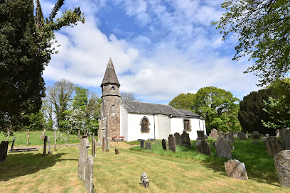
| Description | : | St Peter's Church is located bend in the River Derwent, about half a mile south of the village of Camerton in Cumbria. There has been a church here sice around the 11th century. The church was rebuilt in 1694 and again in 1796, with the 'Gothic Revival' style tower and spire built in 1855. There is a life-size effigy of Sir Thomas Curwen (nicknamed 'Black Tom of the North'), dated 1510, in the church[1] (the Black Tom pub in Camerton is named after him). There is also wooden panelling, removed from Camerton Hall, which is dated 1625 and inscribed B.C.... Read More |
frequently asked questions (FAQ):
-
Where is St Peter's Churchyard?
St Peter's Churchyard is located at Camerton, Cumbria, England Camerton, Allerdale Borough ,Cumbria ,England.
-
St Peter's Churchyard cemetery's updated grave count on graveviews.com?
0 memorials
-
Where are the coordinates of the St Peter's Churchyard?
Latitude: 54.6562240
Longitude: -3.4969760
Nearby Cemetories:
1. Saint Lukes Churchyard
Little Clifton, Allerdale Borough, England
Coordinate: 54.6483200, -3.4679900
2. Flimby Cemetery
Flimby, Allerdale Borough, England
Coordinate: 54.6844750, -3.5163970
3. St. John's Churchyard
Workington, Allerdale Borough, England
Coordinate: 54.6413935, -3.5442752
4. St Nicholas' Churchyard
Flimby, Allerdale Borough, England
Coordinate: 54.6854920, -3.5158820
5. St Columba Churchyard
Broughton Moor, Allerdale Borough, England
Coordinate: 54.6866710, -3.4696330
6. St Michael's Church
Workington, Allerdale Borough, England
Coordinate: 54.6457000, -3.5553000
7. Harrington Road Cemetery
Workington, Allerdale Borough, England
Coordinate: 54.6380140, -3.5512390
8. Christ Churchyard
Great Broughton, Allerdale Borough, England
Coordinate: 54.6713960, -3.4356630
9. Saint Bridgets Churchyard
Brigham, Allerdale Borough, England
Coordinate: 54.6648910, -3.4193640
10. Brigham Cemetery
Brigham, Allerdale Borough, England
Coordinate: 54.6643900, -3.4186090
11. Salterbeck Cemetery
Workington, Allerdale Borough, England
Coordinate: 54.6221220, -3.5659930
12. St Oswald Churchyard
Dean, Allerdale Borough, England
Coordinate: 54.6148500, -3.4403080
13. St. Mary - Harrington
Allerdale Borough, England
Coordinate: 54.6163200, -3.5588400
14. Friends' Burial Ground
Eaglesfield, Allerdale Borough, England
Coordinate: 54.6389500, -3.4063150
15. Distington Hall Crematorium
Distington, Copeland Borough, England
Coordinate: 54.5997900, -3.5260050
16. St Mary's Churchyard
Maryport, Allerdale Borough, England
Coordinate: 54.7153300, -3.4947700
17. Friends Burying Ground
Maryport, Allerdale Borough, England
Coordinate: 54.7183000, -3.4993000
18. Dearham Cemetery
Dearham, Allerdale Borough, England
Coordinate: 54.7102360, -3.4374800
19. Distington Parish Church
Distington, Copeland Borough, England
Coordinate: 54.5975250, -3.5428840
20. St Mungo Churchyard
Dearham, Allerdale Borough, England
Coordinate: 54.7139630, -3.4412770
21. St. Philip Churchyard. Blindbothel
Cockermouth, Allerdale Borough, England
Coordinate: 54.6396550, -3.3852100
22. Pardshaw Quaker Cemetery
Cockermouth, Allerdale Borough, England
Coordinate: 54.6165510, -3.3892360
23. Maryport Cemetery
Maryport, Allerdale Borough, England
Coordinate: 54.7294530, -3.4754560
24. All Saints Churchyard
Cockermouth, Allerdale Borough, England
Coordinate: 54.6631840, -3.3601330