
| Memorials | : | 16 |
| Location | : | Chillingham, Northumberland Unitary Authority, England |
| Coordinate | : | 55.5273100, -1.9030830 |
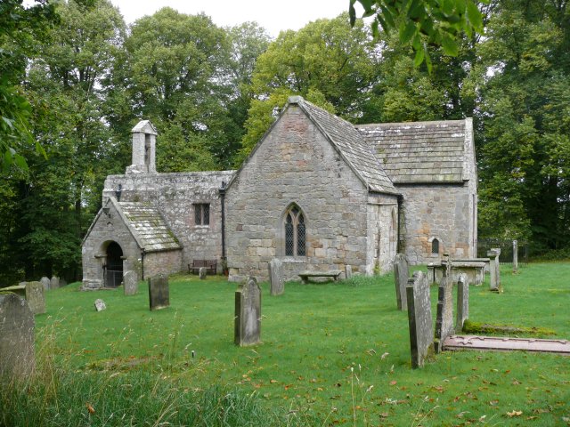
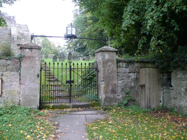
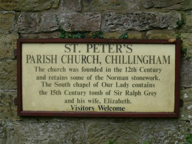
| Description | : | This small stone building with a stone slab roof and small bell cote was founded in the 12th century, and retains some of the Norman stonework. Set on the Chillingham estate, it dates from the same time as the castle, a short distance away. The nave is 12th century, but the chancel is probably 13th century. The roof was replaced in 16th cnetury, and the bell cote added in 18th century. The porch is 19th century; The surrounding graveyard has 18th and 19th century gravestones surrounded by trees. The south transept contains the splendid 15th century alabaster tomb of the... Read More |
frequently asked questions (FAQ):
-
Where is St. Peter's Parish Church?
St. Peter's Parish Church is located at Chillingham, Northumberland Unitary Authority ,Northumberland ,England.
-
St. Peter's Parish Church cemetery's updated grave count on graveviews.com?
16 memorials
-
Where are the coordinates of the St. Peter's Parish Church?
Latitude: 55.5273100
Longitude: -1.9030830
Nearby Cemetories:
1. Holy Cross Churchyard
Chatton, Northumberland Unitary Authority, England
Coordinate: 55.5474907, -1.9105738
2. St. Michael Churchyard
Ilderton, Northumberland Unitary Authority, England
Coordinate: 55.4904200, -1.9743800
3. St Maurice Churchyard
Eglingham, Northumberland Unitary Authority, England
Coordinate: 55.4689000, -1.8336000
4. St Mary & St Michael Churchyard
Doddington, Northumberland Unitary Authority, England
Coordinate: 55.5837211, -2.0083409
5. Saint Mary's Churchyard
Belford, Northumberland Unitary Authority, England
Coordinate: 55.5992600, -1.8292900
6. Saint Hilda’s Churchyard
Lucker, Northumberland Unitary Authority, England
Coordinate: 55.5660400, -1.7597400
7. St. Michael and All Angels Churchyard
Ingram, Northumberland Unitary Authority, England
Coordinate: 55.4405530, -1.9706240
8. St Maurice's Churchyard
Ellingham, Northumberland Unitary Authority, England
Coordinate: 55.5245000, -1.7245300
9. Bolton Chapel
Edlingham, Northumberland Unitary Authority, England
Coordinate: 55.4168580, -1.8335818
10. Hulne Priory
Alnwick, Northumberland Unitary Authority, England
Coordinate: 55.4350530, -1.7430160
11. Saint Nicholas Churchyard
Kyloe, Northumberland Unitary Authority, England
Coordinate: 55.6569000, -1.9188300
12. Kyloe Cemetery
Kyloe, Northumberland Unitary Authority, England
Coordinate: 55.6570310, -1.9191950
13. Grey Family Cemetery
Fallodon, Northumberland Unitary Authority, England
Coordinate: 55.5058580, -1.6760530
14. St John the Baptist Churchyard
Lowick, Northumberland Unitary Authority, England
Coordinate: 55.6501470, -1.9826250
15. St. Aidan Churchyard
Bamburgh, Northumberland Unitary Authority, England
Coordinate: 55.6079810, -1.7183070
16. Rock Church of St. Philip and St. James
Alnwick, Northumberland Unitary Authority, England
Coordinate: 55.4755200, -1.6817200
17. St Gregory Churchyard
Kirknewton, Northumberland Unitary Authority, England
Coordinate: 55.5658590, -2.1387780
18. St Michael and All Angels Churchyard
Ford, Northumberland Unitary Authority, England
Coordinate: 55.6301700, -2.0895430
19. St. Michael & All Angels Churchyard
Alnham, Northumberland Unitary Authority, England
Coordinate: 55.3926170, -2.0159210
20. Alnwick Abbey
Alnwick, Northumberland Unitary Authority, England
Coordinate: 55.4198500, -1.7191400
21. Beadnell cemetery
Beadnell, Northumberland Unitary Authority, England
Coordinate: 55.5572940, -1.6398270
22. Saint Ebba Churchyard
Beadnell, Northumberland Unitary Authority, England
Coordinate: 55.5566380, -1.6375270
23. St. Mary the Virgin Parish Churchyard
Holy Island, Northumberland Unitary Authority, England
Coordinate: 55.6694200, -1.8016450
24. Holy Trinity Churchyard
Embleton, Northumberland Unitary Authority, England
Coordinate: 55.4955790, -1.6360190