
| Memorials | : | 1 |
| Location | : | Brown Candover, Basingstoke and Deane Borough, England |
| Coordinate | : | 51.1536430, -1.1693140 |
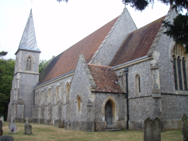
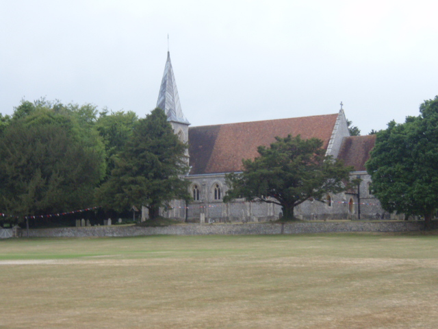
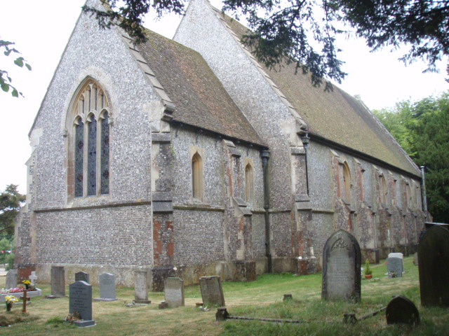
| Description | : | St Peter's Church, Brown Candover replaced a mediaeval church which was situated at the western end of the village. This older church was in use up to the 19th C but fell into disrepair and was pulled down. The cost of building the new church in Brown Candover was mainly borne by Lord Ashburton whose family seat was the Grange at Northington and who owned much of the land in the neighbourhood. The church, designed by Thomas Henry Wyatt, was built in 1844 using knapped flints in a regular pattern and freestone for the window tracery and other ornamental details.... Read More |
frequently asked questions (FAQ):
-
Where is St Peter Churchyard?
St Peter Churchyard is located at B3046 Brown Candover, Basingstoke and Deane Borough ,Hampshire , SO24 9TTEngland.
-
St Peter Churchyard cemetery's updated grave count on graveviews.com?
1 memorials
-
Where are the coordinates of the St Peter Churchyard?
Latitude: 51.1536430
Longitude: -1.1693140
Nearby Cemetories:
1. St. Mary the Virgin Old Churchyard
Preston Candover, Basingstoke and Deane Borough, England
Coordinate: 51.1688476, -1.1380713
2. St John the Evangelist Churchyard
Northington, City of Winchester, England
Coordinate: 51.1329800, -1.1945270
3. St. Mary the Virgin Churchyard
Preston Candover, Basingstoke and Deane Borough, England
Coordinate: 51.1699530, -1.1336090
4. St. John's Churchyard Woodmancote
Popham, Basingstoke and Deane Borough, England
Coordinate: 51.1793597, -1.1968517
5. St James Churchyard
Woodmancott, City of Winchester, England
Coordinate: 51.1794310, -1.1970660
6. All Saints Churchyard
East Stratton, City of Winchester, England
Coordinate: 51.1573920, -1.2275280
7. St. James' Churchyard
Wield, East Hampshire District, England
Coordinate: 51.1446800, -1.1027700
8. St. Catherine Churchyard
Popham, Basingstoke and Deane Borough, England
Coordinate: 51.1930200, -1.2046624
9. St. Mary's Churchyard
Nutley, Basingstoke and Deane Borough, England
Coordinate: 51.1965110, -1.1291030
10. All Saints Churchyard
Bradley, Basingstoke and Deane Borough, England
Coordinate: 51.1719500, -1.0923600
11. Basingstoke Crematorium and Gardens of Remembrance
North Waltham, Basingstoke and Deane Borough, England
Coordinate: 51.2019400, -1.2013550
12. All Saints Churchyard
Bighton, City of Winchester, England
Coordinate: 51.1064610, -1.1297250
13. St. Mary the Virgin Churchyard
Old Alresford, City of Winchester, England
Coordinate: 51.0992190, -1.1616240
14. All Saints Churchyard
Dummer, Basingstoke and Deane Borough, England
Coordinate: 51.2103290, -1.1588850
15. St. Mary the Virgin Churchyard
Micheldever, City of Winchester, England
Coordinate: 51.1491220, -1.2683430
16. St Michael Churchyard
North Waltham, Basingstoke and Deane Borough, England
Coordinate: 51.2140600, -1.1989400
17. St John the Baptist Churchyard
New Alresford, City of Winchester, England
Coordinate: 51.0901440, -1.1611070
18. St Mary Churchyard
Itchen Stoke, City of Winchester, England
Coordinate: 51.0883550, -1.2030240
19. St Andrew Churchyard
Medstead, East Hampshire District, England
Coordinate: 51.1299560, -1.0657490
20. Medstead Cemetery
Medstead, East Hampshire District, England
Coordinate: 51.1271700, -1.0620900
21. St Nicholas Churchyard
Bishops Sutton, City of Winchester, England
Coordinate: 51.0841830, -1.1360550
22. St Nicholas Churchyard
Steventon, Basingstoke and Deane Borough, England
Coordinate: 51.2214000, -1.2123600
23. St Mary Churchyard
Bentworth, East Hampshire District, England
Coordinate: 51.1579100, -1.0500600
24. St Mary Churchyard
Bentworth, East Hampshire District, England
Coordinate: 51.1579900, -1.0499460