| Memorials | : | 1 |
| Location | : | Narooma, Eurobodalla Shire, Australia |
| Coordinate | : | -36.2419000, 150.1047000 |
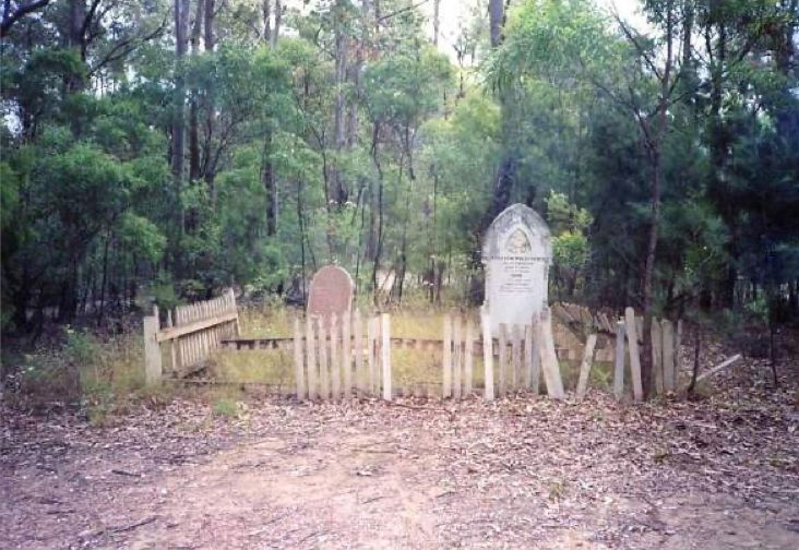
| Description | : | St Philip’s Church was built in 1886, however, owing to its significant distance from town, St Paul’s Church of England was built, in town, in 1900. St Philip’s continued to hold services weekly until a bushfire destroyed the church on November 7th, 1928. The bushfire also destroyed a number of the wooden headstone crosses in the cemetery. However the burial ground continued to be utilised up until 1939, when the last known burial was conducted. There is at least 17 known burials at St Philip’s Cemetery, however only 4 headstones remained. These headstones were removed and relocated to... Read More |
frequently asked questions (FAQ):
-
Where is St Philips Church of England Cemetery?
St Philips Church of England Cemetery is located at 6 Wagonga Scenic Drive Narooma, Eurobodalla Shire ,New South Wales , 2546Australia.
-
St Philips Church of England Cemetery cemetery's updated grave count on graveviews.com?
1 memorials
-
Where are the coordinates of the St Philips Church of England Cemetery?
Latitude: -36.2419000
Longitude: 150.1047000
Nearby Cemetories:
1. Narooma General Cemetery
Narooma, Eurobodalla Shire, Australia
Coordinate: -36.2279806, 150.1419222
2. Narooma Headland Burials
Narooma, Eurobodalla Shire, Australia
Coordinate: -36.2143060, 150.1356750
3. Wagonga Cemetery
Wagonga, Eurobodalla Shire, Australia
Coordinate: -36.2166672, 150.0500031
4. Albert Read's Grave Tiverton
Central Tilba, Eurobodalla Shire, Australia
Coordinate: -36.3323020, 150.1008593
5. Tilba District Cemetery
Tilba Tilba, Eurobodalla Shire, Australia
Coordinate: -36.3364580, 150.1015230
6. Montague Island Cemetery
Narooma, Eurobodalla Shire, Australia
Coordinate: -36.2551140, 150.2266290
7. Bottin Family Cemetery
Dignams Creek, Bega Valley Shire, Australia
Coordinate: -36.2428830, 149.9705940
8. John Young Family Vault
Akolele, Eurobodalla Shire, Australia
Coordinate: -36.3554900, 150.0772200
9. Southam Family Cemetery
Tilba Tilba, Eurobodalla Shire, Australia
Coordinate: -36.3494830, 150.0438260
10. Eurobodalla Graves
Eurobodalla Shire, Australia
Coordinate: -36.1394800, 149.9812190
11. Bodalla General Cemetery
Bodalla, Eurobodalla Shire, Australia
Coordinate: -36.0833321, 150.0500031
12. Bermagui General Cemetery
Bermagui, Bega Valley Shire, Australia
Coordinate: -36.4376630, 150.0715080
13. Old Nerrigundah Cemetery
Nerrigundah, Eurobodalla Shire, Australia
Coordinate: -36.1213440, 149.9102380
14. Cobargo Cemetery
Cobargo, Bega Valley Shire, Australia
Coordinate: -36.3823000, 149.8956600
15. Bingi Bingi Brinja Aboriginal massacre site
Bergalia, Eurobodalla Shire, Australia
Coordinate: -36.0214600, 150.1511990
16. Congo Point Colonial Grave
Congo Park, Eurobodalla Shire, Australia
Coordinate: -35.9559590, 150.1580970
17. Quaama Cemetery
Bega, Bega Valley Shire, Australia
Coordinate: -36.4694305, 149.8739619
18. Moruya Cemetery
Moruya, Eurobodalla Shire, Australia
Coordinate: -35.9233510, 150.0755760
19. Kiora Cemetery
Kiora, Eurobodalla Shire, Australia
Coordinate: -35.9167050, 150.0411770
20. Moruya Heads Cemetery
Moruya Heads, Eurobodalla Shire, Australia
Coordinate: -35.9087270, 150.1612160
21. Lucks Cemetery
Moruya, Eurobodalla Shire, Australia
Coordinate: -35.9085890, 150.0426920
22. Frederic Lester-Blanchard Lone Grave
Eurobodalla Shire, Australia
Coordinate: -35.9330700, 149.9278000
23. Glenduart Cemetery
Moruya, Eurobodalla Shire, Australia
Coordinate: -35.8896350, 150.0670760
24. Broulee Memorial Gardens & Crematorium
Broulee, Eurobodalla Shire, Australia
Coordinate: -35.8550440, 150.1430800

