
| Memorials | : | 0 |
| Location | : | Chestnut Fork, Bedford County, USA |
| Coordinate | : | 37.1777750, -79.4857920 |
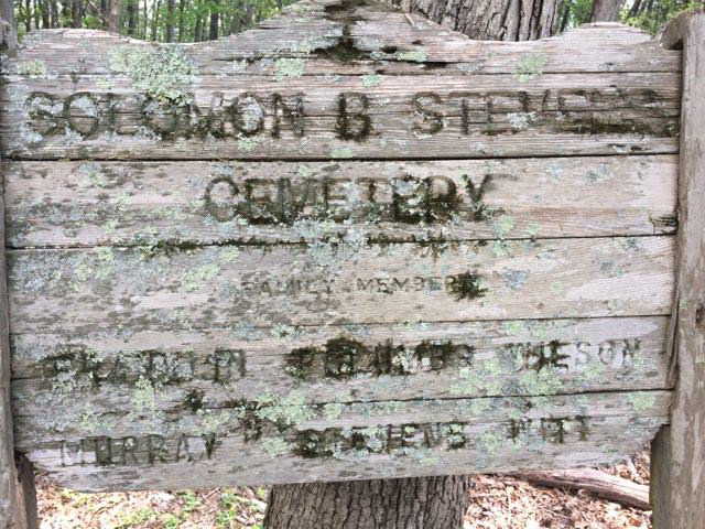
| Description | : | Cemetery is on the west side of Route 727 near Crab Orchard Creek. This farm later was the property of Samuel L. Leftwich, then Hackworth, and now L. J. Bays. Turn Northwest off 727 at 0.3 miles West of 731(NO) onto private road and go past abandoned house for 0.35 miles and stop about 100 yards short of a red gate. Cemetery is found in the woods about 75 yards east of this road. Large wooden sign: "Solomon B. Stevens/Stephens Cemetery" FAMILY MEMBERS: FRANKLIN, POLUMBO, WILSON, MURRAY, STEVENS/STEPHENS, WITT. SOME WHERE MARKED WITH FIELD STONES & UNMARKED.. We owe a great deal of thanks to... Read More |
frequently asked questions (FAQ):
-
Where is Stephens Cemetery?
Stephens Cemetery is located at Chestnut Fork, Bedford County ,Virginia ,USA.
-
Stephens Cemetery cemetery's updated grave count on graveviews.com?
0 memorials
-
Where are the coordinates of the Stephens Cemetery?
Latitude: 37.1777750
Longitude: -79.4857920
Nearby Cemetories:
1. Creasey-Overstreet-Crouch Cemetery
Chestnut Fork, Bedford County, USA
Coordinate: 37.1927680, -79.5094994
2. Quaker Baptist Church Cemetery
Chestnut Fork, Bedford County, USA
Coordinate: 37.2061940, -79.5162270
3. William Sampson Mayhew Family Cemetery
Chestnut Fork, Bedford County, USA
Coordinate: 37.2172500, -79.4978900
4. Overstreet-Crowder-Foster Cemetery
Chestnut Fork, Bedford County, USA
Coordinate: 37.2243370, -79.4996150
5. Central Baptist Church Cemetery
Bedford County, USA
Coordinate: 37.2052935, -79.5359414
6. Mount Zion Baptist Church Cemetery
Bedford, Bedford County, USA
Coordinate: 37.2225010, -79.5123250
7. Mount Zion Baptist Church Cemetery
Bedford, Bedford County, USA
Coordinate: 37.2085300, -79.5375320
8. Cheek-Lewis-Landsdown-Mayhew-Overstreet Plot
Bedford County, USA
Coordinate: 37.2269410, -79.5105890
9. Preston and Sinthia Leftwich Cemetery
Gillespie, Bedford County, USA
Coordinate: 37.2137880, -79.4318820
10. Wilsons United Methodist Church Cemetery
Bedford, Bedford County, USA
Coordinate: 37.2322740, -79.5112800
11. McConnehey-Updike Cemetery
Chestnut Fork, Bedford County, USA
Coordinate: 37.2116187, -79.5452689
12. Wade Cemetery
Gillespie, Bedford County, USA
Coordinate: 37.2287910, -79.4475890
13. Church of the Great Shepherd Cemetery
Bedford, Bedford County, USA
Coordinate: 37.2255209, -79.5409872
14. Witt Family Cemetery
Bunker Hill, Bedford County, USA
Coordinate: 37.2456010, -79.5152070
15. Charles Fitzhugh Walker Cemetery
Bedford County, USA
Coordinate: 37.2497454, -79.4786622
16. Fred A Sims Cemetery
Bedford County, USA
Coordinate: 37.2508287, -79.4719383
17. George Hackworth Family Cemetery
Bedford County, USA
Coordinate: 37.1091934, -79.4287537
18. Bold Branch Baptist Church Cemetery
Bedford, Bedford County, USA
Coordinate: 37.2514610, -79.4391110
19. Morgans Baptist Church Cemetery
Bedford, Bedford County, USA
Coordinate: 37.1896961, -79.5920278
20. Bethany Memorial Cemetery
Lynch Station, Campbell County, USA
Coordinate: 37.1331870, -79.3910470
21. Leesville United Methodist Church Cemetery
Leesville, Campbell County, USA
Coordinate: 37.1177300, -79.3900040
22. Snow Family Cemetery
Leesville, Campbell County, USA
Coordinate: 37.0928648, -79.4090029
23. Hickory Grove Church Cemetery
Five Forks, Bedford County, USA
Coordinate: 37.2843338, -79.4882560
24. Zimmerman Family Cemetery
Bedford, Bedford County, USA
Coordinate: 37.2816850, -79.5191559