
| Memorials | : | 5 |
| Location | : | Chania, Regional unit of Chania, Greece |
| Coordinate | : | 35.5000800, 24.0612100 |
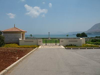
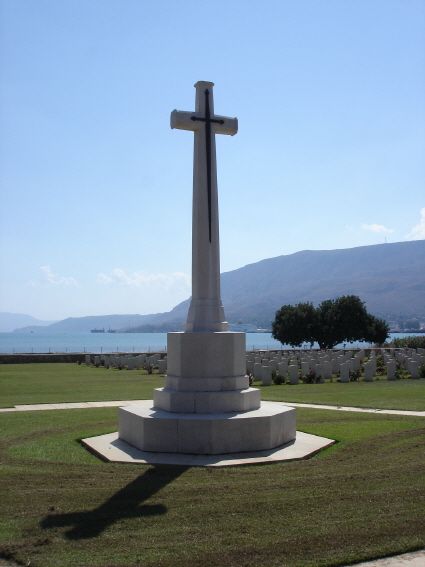
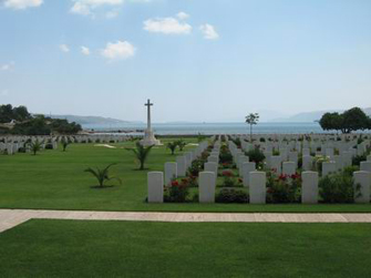
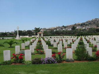
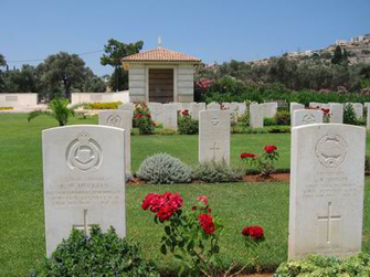
| Description | : | Suda Bay War Cemetery is located approximately 5 km east from the centre of Chania (Xania). From Chania follow the Suda Boulevard road for approximately 4 km until you arrive at the junction of Ellis and then turn left following the signs for the Airport and Vlite. Proceed for around 200 metres along this road until you arrive at the junction of Mavridaki Street. Turn left onto Mavridaki Street and follow this road for 400 metres until you come to the CWGC sign on the right hand side. Proceed for a further 100 metres and turn right at the next... Read More |
frequently asked questions (FAQ):
-
Where is Suda Bay War Cemetery?
Suda Bay War Cemetery is located at Chania, Regional unit of Chania ,Crete ,Greece.
-
Suda Bay War Cemetery cemetery's updated grave count on graveviews.com?
4 memorials
-
Where are the coordinates of the Suda Bay War Cemetery?
Latitude: 35.5000800
Longitude: 24.0612100
Nearby Cemetories:
1. Chania Holy Bright Cemetery
Chania, Regional unit of Chania, Greece
Coordinate: 35.5156300, 24.0448400
2. Chania St. Luke Cemetery
Chania, Regional unit of Chania, Greece
Coordinate: 35.5064300, 24.0202300
3. Argoulide Cemetery
Chania, Regional unit of Chania, Greece
Coordinate: 35.5281250, 24.0998570
4. Kounoupidhiana cemetery
Kounoupidhiana, Regional unit of Chania, Greece
Coordinate: 35.5391500, 24.0847500
5. Vamvakopoulo Cemetery
Chania, Regional unit of Chania, Greece
Coordinate: 35.5001900, 23.9879800
6. Perivolia cemetery
Perivolia, Regional unit of Chania, Greece
Coordinate: 35.4807100, 23.9882500
7. Chorafakia cemetery
Chorafakia, Regional unit of Chania, Greece
Coordinate: 35.5582900, 24.0980800
8. Galatas Cemetery (Κοιμητήριο Γαλατά)
Galatas, Regional unit of Chania, Greece
Coordinate: 35.4925080, 23.9664820
9. Αγία Άννα
Meskla, Regional unit of Chania, Greece
Coordinate: 35.4098706, 23.9565538
10. Maleme German War Cemetery
Maleme, Regional unit of Chania, Greece
Coordinate: 35.5220150, 23.8310340
11. Saint Onoufrios Church
Alonai, Regional unit of Rethymno, Greece
Coordinate: 35.2395697, 24.3431465
12. Νεκροταφείο Βενερατου
Veneraton, Regional unit of Heraklion, Greece
Coordinate: 35.1975168, 25.0406244
13. Nea Alikarnassos
Nea Alikarnassos, Regional unit of Heraklion, Greece
Coordinate: 35.3341000, 25.1633300
14. Churchyard
Gerakas, Regional unit of Laconia, Greece
Coordinate: 36.7455760, 23.0547690
15. Ios Municipal Cemetery
Ios, Regional unit of Thira, Greece
Coordinate: 36.7215667, 25.2854214
16. Kechrianika Cemetery
Kekhrianika, Regional unit of Laconia, Greece
Coordinate: 36.4967658, 22.3923652
17. Jubilee Park Cemetery
Uitenhage, Nelson Mandela Bay Metropolitan Municipality, South Africa
Coordinate: 33.7590830, 25.3820000
18. Holy Trinity Cemetery
Regional unit of Laconia, Greece
Coordinate: 37.0833330, 22.3500000
19. Karyes Cemetery
Sparta, Regional unit of Laconia, Greece
Coordinate: 37.2947510, 22.4999688
20. Municipal Cemetery of Kalamata
Kalamata, Regional unit of Messenia, Greece
Coordinate: 37.0434910, 22.1197042
21. Tolon Cemetery
Tolon, Regional unit of Argolis, Greece
Coordinate: 37.5189000, 22.8560500
22. Arkadiko Cemetery
Arkadiko, Regional unit of Argolis, Greece
Coordinate: 37.5948500, 22.9480800
23. Agios Nektarios Holy Trinity - Monastery Aegina
Aegina Island, Regional unit of Islands, Greece
Coordinate: 37.7474635, 23.4840349
24. Κοιμητήριο Σταθμού (Εκκλησάκι Αγίων Πάντων)
Skala, Regional unit of Messenia, Greece
Coordinate: 37.1958010, 21.9996910