
| Memorials | : | 0 |
| Location | : | Cottonwood, Houston County, USA |
| Coordinate | : | 31.0723900, -85.2953300 |
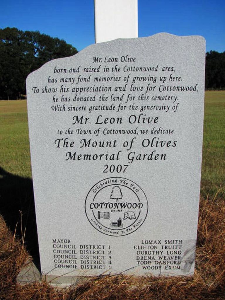
| Description | : | Mr. Leon Olive born and raised in the Cottonwood area has many fond memories of growing up here. The show his appreciation and love for Cottonwood, he has donated the land for this cemetery. With sincere gratitude for the generosity of Mr. Leon Olive to the Town of Cottonwood, we dedicate The Mount of Olives Memorial Garden 2007. |
frequently asked questions (FAQ):
-
Where is The Mount of Olives Memorial Garden?
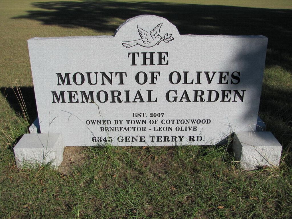
The Mount of Olives Memorial Garden is located at 6345 Gene Terry Rd. Cottonwood, Houston County ,Alabama , 36320USA.
-
The Mount of Olives Memorial Garden cemetery's updated grave count on graveviews.com?
0 memorials
-
Where are the coordinates of the The Mount of Olives Memorial Garden?
Latitude: 31.0723900
Longitude: -85.2953300
Nearby Cemetories:
1. Union Hill Missionary Baptist Church Cemetery
Cottonwood, Houston County, USA
Coordinate: 31.0593359, -85.2872273
2. Cottonwood City Cemetery
Cottonwood, Houston County, USA
Coordinate: 31.0470104, -85.3054886
3. Union Hill Baptist Cemetery
Cottonwood, Houston County, USA
Coordinate: 31.0988520, -85.3115790
4. Love Hill Assembly Of God Church Cemetery
Ashford, Houston County, USA
Coordinate: 31.1133930, -85.2760010
5. Howard Grove Primitive Baptist Church Cemetery
Cottonwood, Houston County, USA
Coordinate: 31.1049652, -85.2574921
6. Ramah Baptist Church Cemetery
Houston County, USA
Coordinate: 31.0334454, -85.3304825
7. Hickory Grove Baptist Church Cemetery
Cottonwood, Houston County, USA
Coordinate: 31.0544770, -85.2409130
8. Mount Zion Baptist Church Cemetery
Cottonwood, Houston County, USA
Coordinate: 31.0222111, -85.2943420
9. Harpers Joy Assembly of God Cemetery
Dothan, Houston County, USA
Coordinate: 31.1058470, -85.3459760
10. Frith Hill Community Church Cemetery
Houston County, USA
Coordinate: 31.1285670, -85.3118880
11. Saint Marys Methodist Church Cemetery
Cottonwood, Houston County, USA
Coordinate: 31.0419640, -85.3602450
12. New Harmony Freewill Baptist Church Cemetery
Cottonwood, Houston County, USA
Coordinate: 31.0247580, -85.2452860
13. Hodgesville Baptist Church Cemetery
Dothan, Houston County, USA
Coordinate: 31.0837803, -85.3710785
14. Clayton Church Cemetery
Houston County, USA
Coordinate: 31.0513859, -85.2175293
15. Enterprise Baptist Church Cemetery
Ashford, Houston County, USA
Coordinate: 31.1510930, -85.2784090
16. Cowarts Creek Cemetery
Houston County, USA
Coordinate: 31.1527996, -85.3063965
17. Mount Enon Baptist Cemetery
Houston County, USA
Coordinate: 31.0980396, -85.3902283
18. Antioch Assembly of God Church Cemetery
Cottonwood, Houston County, USA
Coordinate: 31.0098991, -85.2246704
19. Madrid City Cemetery
Madrid, Houston County, USA
Coordinate: 31.0310650, -85.3884811
20. Antioch Baptist Church Cemetery
Ashford, Houston County, USA
Coordinate: 31.1310196, -85.2154465
21. Bethlehem Assembly of God Cemetery
Gordon, Houston County, USA
Coordinate: 31.0555400, -85.1904400
22. Memphis Baptist Church Cemetery
Dothan, Houston County, USA
Coordinate: 31.1413994, -85.3675003
23. Rocky Creek Methodist Church Cemetery
Ashford, Houston County, USA
Coordinate: 31.1174526, -85.1999283
24. Family Harvest Worship Center Cemetery
Grangeburg, Houston County, USA
Coordinate: 31.0085800, -85.2106400