
| Memorials | : | 422 |
| Location | : | Tidavad, Mariestads kommun, Sweden |
| Coordinate | : | 58.5833190, 13.8534270 |
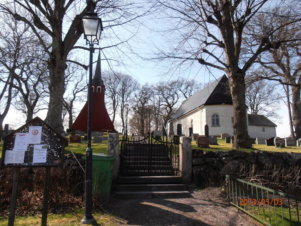
| Description | : | A small cemetery on a hillside with a red wooden clocktower to the left/south of the white church. The church was probably built in the second half of the 1100's and was rebuilt (added to) in the 1700's. The cemetery is split into six parts (A-F) and surrounded by a low stone wall, the outside of the wall is higher than the inside. The main gate is to the east with stairs up to the cemetery road leading to the west gate on the other side. There's also small stairs added as a part of the north wall, near the... Read More |
frequently asked questions (FAQ):
-
Where is Tidavads kyrkogård?
Tidavads kyrkogård is located at Tidavad, Mariestads kommun ,Västra Götalands län ,Sweden.
-
Tidavads kyrkogård cemetery's updated grave count on graveviews.com?
422 memorials
-
Where are the coordinates of the Tidavads kyrkogård?
Latitude: 58.5833190
Longitude: 13.8534270
Nearby Cemetories:
1. Ekby kyrkogård
Ekby, Mariestads kommun, Sweden
Coordinate: 58.6131860, 13.8668190
2. Odensåkers kyrkogård
Odensaker, Mariestads kommun, Sweden
Coordinate: 58.5538500, 13.8838300
3. Eks gamla kyrkogård
Ek, Mariestads kommun, Sweden
Coordinate: 58.6148510, 13.8157790
4. Böja Kyrkogård
Boja, Skövde kommun, Sweden
Coordinate: 58.5542230, 13.7757480
5. Binnebergs kyrkogård
Binneberg, Skövde kommun, Sweden
Coordinate: 58.5208473, 13.8652615
6. Horn Kyrkogärd
Skövde kommun, Sweden
Coordinate: 58.5210980, 13.8940840
7. Ullervad Kyrkogården
Ullervad, Mariestads kommun, Sweden
Coordinate: 58.6661110, 13.8645470
8. Mo Kyrkogård
Moholm, Töreboda kommun, Sweden
Coordinate: 58.6034440, 14.0528890
9. Bällefors Cemetery
Töreboda kommun, Sweden
Coordinate: 58.6031878, 14.0530267
10. Björsäter
Bjorsater, Mariestads kommun, Sweden
Coordinate: 58.6551600, 13.6991400
11. Säter Cemetery
Skövde kommun, Sweden
Coordinate: 58.4681421, 13.8385296
12. Fägre kyrkogård
Fagre, Töreboda kommun, Sweden
Coordinate: 58.6366600, 14.0843790
13. Holmestad Cemetery
Holmestad, Götene kommun, Sweden
Coordinate: 58.5409768, 13.5704366
14. Öglunda Kyrkogård
Oglunda, Skara kommun, Sweden
Coordinate: 58.4333860, 13.6907500
15. Hassle Kyrkogård
Hassleror, Mariestads kommun, Sweden
Coordinate: 58.7543120, 13.9438180
16. Toreboda kyrkogard
Töreboda, Töreboda kommun, Sweden
Coordinate: 58.7093500, 14.1208000
17. Saint Elins Kyrkogård
Skövde, Skövde kommun, Sweden
Coordinate: 58.3937400, 13.8436450
18. Forshem Cemetery
Forshem, Götene kommun, Sweden
Coordinate: 58.6197450, 13.4900355
19. Sankta Helena kyrka
Skövde, Skövde kommun, Sweden
Coordinate: 58.3891070, 13.8471540
20. Fullösa Kyrkogård
Fullosa, Götene kommun, Sweden
Coordinate: 58.5818900, 13.4789200
21. Vättlösa kyrkogård
Götene kommun, Sweden
Coordinate: 58.5123370, 13.4918200
22. Våmbs kyrkogård
Vamb, Skövde kommun, Sweden
Coordinate: 58.3823220, 13.8141170
23. Fredsbergs kyrkogård
Fredsberg, Töreboda kommun, Sweden
Coordinate: 58.7560490, 14.0655900
24. Kestads Kyrka
Kestad, Götene kommun, Sweden
Coordinate: 58.5653684, 13.4501088