
| Memorials | : | 0 |
| Location | : | Leesville, Henry County, USA |
| Coordinate | : | 38.3526710, -93.5567590 |
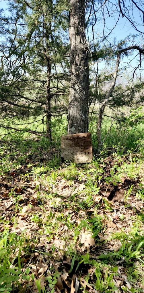
| Description | : | SE PP 55 The ground is South of Truman Lake near the Old Tebo Church site which is now underwater. Was told by a local man who has lived in the area told me that the landowner, whom owned prior to the current one, told him that the area used to have at least 5-10 to graves/ grave markers. However over time the ones that were made of sandstone had eroded away and now only one grave marker remains; Hannah Short. This stone can be found in a thicket of trees and brush under a large tree. ... Read More |
frequently asked questions (FAQ):
-
Where is Timberlake Cemetery?
Timberlake Cemetery is located at Leesville, Henry County ,Missouri ,USA.
-
Timberlake Cemetery cemetery's updated grave count on graveviews.com?
0 memorials
-
Where are the coordinates of the Timberlake Cemetery?
Latitude: 38.3526710
Longitude: -93.5567590
Nearby Cemetories:
1. Tebo Church Cemetery
Leesville, Henry County, USA
Coordinate: 38.3538017, -93.5447998
2. Baugh Cemetery
Benton County, USA
Coordinate: 38.3622017, -93.4989014
3. Tindle Cemetery
Lincoln, Benton County, USA
Coordinate: 38.3469009, -93.4961014
4. Logan Cemetery
Leesville, Henry County, USA
Coordinate: 38.3051186, -93.5282211
5. Fewell Farm Graveyard
Benton County, USA
Coordinate: 38.3922100, -93.5109000
6. Parks Chapel Cemetery
Leesville, Henry County, USA
Coordinate: 38.2966805, -93.5707474
7. George Grave Yard
Calhoun, Henry County, USA
Coordinate: 38.4070160, -93.5829940
8. Mount Olivet Cemetery
Roseland, Henry County, USA
Coordinate: 38.4122400, -93.5474300
9. Osborn Cemetery
Benton County, USA
Coordinate: 38.3142014, -93.4946976
10. Summers Family Burial Grounds
Racket, Benton County, USA
Coordinate: 38.3196000, -93.4891900
11. King Cemetery
Leesville, Henry County, USA
Coordinate: 38.3030070, -93.6119360
12. Good Hope Cemetery
Coal, Henry County, USA
Coordinate: 38.3194008, -93.6373978
13. Shady Grove Cemetery
Racket, Benton County, USA
Coordinate: 38.2964700, -93.4970000
14. Combs Cemetery
Clinton, Henry County, USA
Coordinate: 38.3986015, -93.6421967
15. Clear Creek Cemetery
Lincoln, Benton County, USA
Coordinate: 38.3804200, -93.4497100
16. Downing Cemetery (Defunct)
Benton County, USA
Coordinate: 38.2963982, -93.4589005
17. McIntire Chapel Cemetery
Windsor Junction, Benton County, USA
Coordinate: 38.4303017, -93.4760971
18. McMillian Cemetery
Santiago, Benton County, USA
Coordinate: 38.4504800, -93.5072780
19. Sunnyside Cemetery
Lincoln, Benton County, USA
Coordinate: 38.3713400, -93.4242200
20. Cooper Cemetery (Defunct)
Benton County, USA
Coordinate: 38.2661018, -93.4756012
21. Robinson Cemetery
Leesville, Henry County, USA
Coordinate: 38.4566130, -93.5982370
22. Goff Cemetery
Deer Creek Township, Henry County, USA
Coordinate: 38.4537230, -93.6237720
23. Gregory Cemetery
Benton County, USA
Coordinate: 38.3330994, -93.4135971
24. Harmony Baptist Church Cemetery
Benton County, USA
Coordinate: 38.4460600, -93.4643000