
| Memorials | : | 1 |
| Location | : | Tronninge, Varbergs kommun, Sweden |
| Phone | : | +46 35 17 97 00 |
| Website | : | www.svenskakyrkan.se/snostorp/tronninge-kyrka |
| Coordinate | : | 56.6226760, 12.9360640 |
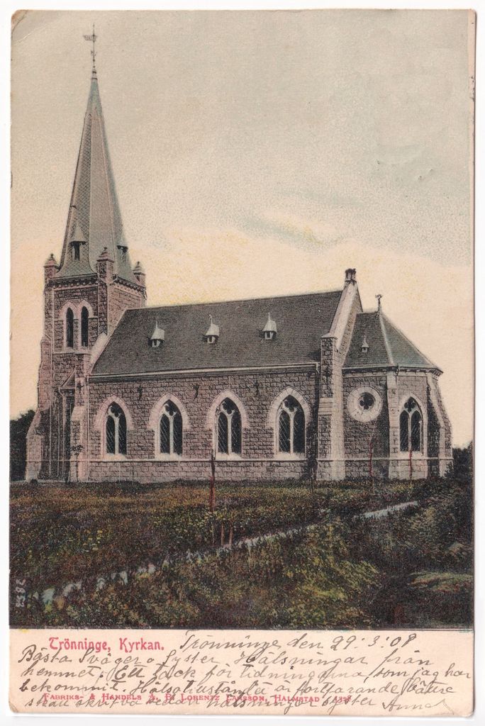
| Description | : | Trönninge church is a church building that since 2013 belongs to the Snöstorp parish (2006-2013 Eldsbergabygdens parish and formerly Trönninge parish ) in the diocese of Gothenburg . It is located in the church village of Trönninge in the municipality of Halmstad . Trönninge stone church was erected in 1893–1894 after drawings by architect Sven Gratz in the Neo-Gothic style . It is walled with unpainted granite and brick on the inside. It has a west tower with a huge spire supported by powerful thrusters. The Longhouse has four large, pointed arched windows with frames framed in light brick. On the... Read More |
frequently asked questions (FAQ):
-
Where is Trönninge Kyrka?
Trönninge Kyrka is located at Västra Vägen 31, 302 65 Halmstad, Sweden Tronninge, Varbergs kommun ,Hallands län ,Sweden.
-
Trönninge Kyrka cemetery's updated grave count on graveviews.com?
1 memorials
-
Where are the coordinates of the Trönninge Kyrka?
Latitude: 56.6226760
Longitude: 12.9360640
Nearby Cemetories:
1. Veinge kyrkogård
Veinge, Laholms kommun, Sweden
Coordinate: 56.5722110, 13.0924670
2. Harplinge Kryrka Cemetery
Harplinge, Halmstads kommun, Sweden
Coordinate: 56.7372320, 12.7377720
3. Ysby Kyrkogård
Laholms kommun, Sweden
Coordinate: 56.4939320, 13.1185930
4. Skogaby Kapell
Skogaby, Laholms kommun, Sweden
Coordinate: 56.5286100, 13.1854600
5. Ränneslövs Kyrkogård
Ranneslov, Laholms kommun, Sweden
Coordinate: 56.4536990, 13.0636290
6. St. Mary's Church Cemetery
Bastad, Båstads kommun, Sweden
Coordinate: 56.4335910, 12.8353360
7. Steninge Kyrka
Steninge, Halmstads kommun, Sweden
Coordinate: 56.7722110, 12.6594470
8. Västra Karups kyrkogård
Bastad, Båstads kommun, Sweden
Coordinate: 56.4109320, 12.7415200
9. Grevie Kyrkogård
Grevie, Båstads kommun, Sweden
Coordinate: 56.3709610, 12.7916820
10. Vrå kyrkogård
Vra, Ljungby kommun, Sweden
Coordinate: 56.7342559, 13.4538185
11. Tåssjö Kyrkogård
Ängelholms kommun, Sweden
Coordinate: 56.3073400, 13.0901200
12. Abild Cemetery
Abild, Falkenbergs kommun, Sweden
Coordinate: 56.9385950, 12.7220710
13. Munka-Ljungby church cemetery
Munka-Ljungby, Ängelholms kommun, Sweden
Coordinate: 56.2604608, 12.9743124
14. Falkenberg Forest Cemetery
Falkenberg, Falkenbergs kommun, Sweden
Coordinate: 56.9028200, 12.4999100
15. Torpa Kyrkogård
Ljungby, Ljungby kommun, Sweden
Coordinate: 56.7094720, 13.5951390
16. Vessige Kyrkogard
Vessigebro, Falkenbergs kommun, Sweden
Coordinate: 56.9763970, 12.6621150
17. Nya Kyrkogården
Örkelljunga kommun, Sweden
Coordinate: 56.2788143, 13.2711418
18. Össjö Kyrkogård
Ängelholm, Ängelholms kommun, Sweden
Coordinate: 56.2287780, 13.0280280
19. Jonstorps Kyrkogård
Höganäs, Höganäs kommun, Sweden
Coordinate: 56.2280360, 12.6719080
20. Odensjö
Odensjo, Ljungby kommun, Sweden
Coordinate: 56.8607780, 13.6149720
21. Ausås Kyrka
Ausas, Ängelholms kommun, Sweden
Coordinate: 56.1670938, 12.8872368
22. Sibbarps kyrkogård
Sibbarp, Herrljunga kommun, Sweden
Coordinate: 57.0276731, 12.5421654
23. Södra Unnaryd
Unnaryd, Hylte kommun, Sweden
Coordinate: 56.9553705, 13.5318068
24. Strovelstorp Kyrka Cemetery
Strovelstorp, Ängelholms kommun, Sweden
Coordinate: 56.1593328, 12.8378950