
| Memorials | : | 1 |
| Location | : | Glendale, Hamilton County, USA |
| Coordinate | : | 39.2621500, -84.4506080 |
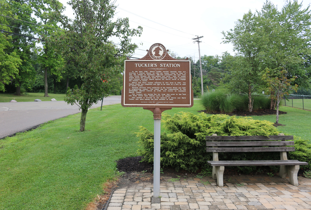
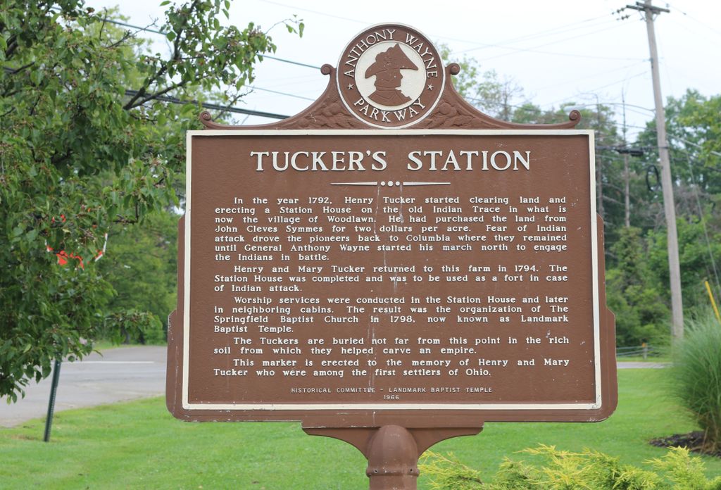
| Description | : | The Tucker Station was established in 1792 when Henry Tucker built a blockhouse in the northwest corner of Springfield Township. This became known as Fort Tucker and/or Tucker Station and was located between Marion and Skillman Roads in Woodlawn beside the railroad track. In 1798, the Springfield Baptist Church was established. A cemetery was located by the church. Per the “History of the Springfield and Lockland Baptist Churches” by J. H. Tangeman, from the Miami Baptist Association Minutes 1875, the church moved from Springfield Township to Lockland in 1840 and became the Lockland Baptist Church. In 1962, the church moved... Read More |
frequently asked questions (FAQ):
-
Where is Tucker Station Cemetery?
Tucker Station Cemetery is located at Chester Road and Oak Road Glendale, Hamilton County ,Ohio , 45215USA.
-
Tucker Station Cemetery cemetery's updated grave count on graveviews.com?
1 memorials
-
Where are the coordinates of the Tucker Station Cemetery?
Latitude: 39.2621500
Longitude: -84.4506080
Nearby Cemetories:
1. Mill Creek Presbyterian Churchyard
Glendale, Hamilton County, USA
Coordinate: 39.2636604, -84.4506836
2. Bethany Episcopal Day School Chapel Crypt
Glendale, Hamilton County, USA
Coordinate: 39.2657260, -84.4539850
3. Landmark Memorial Gardens
Glendale, Hamilton County, USA
Coordinate: 39.2607300, -84.4442300
4. Skillman Family Cemetery
Woodlawn, Hamilton County, USA
Coordinate: 39.2588654, -84.4576950
5. Christ Church Glendale Chapel Columbarium
Glendale, Hamilton County, USA
Coordinate: 39.2721430, -84.4660500
6. Oak Hill Cemetery
Glendale, Hamilton County, USA
Coordinate: 39.2797012, -84.4625015
7. Holy Rood Catholic Cemetery
Glendale, Hamilton County, USA
Coordinate: 39.2760380, -84.4696950
8. Glenmary Mission Seminary Cemetery (Defunct)
Springdale, Hamilton County, USA
Coordinate: 39.2828320, -84.4706510
9. Sharonville Cemetery
Sharonville, Hamilton County, USA
Coordinate: 39.2683520, -84.4147250
10. Voorhees Family Burying Ground
Lockland, Hamilton County, USA
Coordinate: 39.2296982, -84.4480972
11. Old Saint Marys Cemetery
Springdale, Hamilton County, USA
Coordinate: 39.2805176, -84.4852905
12. Reading Cemetery
Reading, Hamilton County, USA
Coordinate: 39.2296982, -84.4419022
13. Saints Peter And Paul Cemetery
Reading, Hamilton County, USA
Coordinate: 39.2308006, -84.4313965
14. Coleman Cemetery
Sharonville, Hamilton County, USA
Coordinate: 39.2705879, -84.4042892
15. Shuff - Myers Pioneer Cemetery
Sharonville, Hamilton County, USA
Coordinate: 39.2593010, -84.4004230
16. Rest Haven Memorial Park
Evendale, Hamilton County, USA
Coordinate: 39.2505989, -84.4005966
17. Beech Grove Cemetery
Springfield Township, Hamilton County, USA
Coordinate: 39.2364006, -84.4916992
18. Cummins Cemetery
Sharonville, Hamilton County, USA
Coordinate: 39.2815666, -84.4005814
19. Sisters of Notre Dame Cemetery
Reading, Hamilton County, USA
Coordinate: 39.2219009, -84.4297028
20. Saints Peter and Paul Old Cemetery
Reading, Hamilton County, USA
Coordinate: 39.2218000, -84.4291800
21. Saint Clare Convent Cemetery
Mount Healthy, Hamilton County, USA
Coordinate: 39.2206750, -84.4782390
22. Whallon Burial Ground (Defunct)
Gano, Butler County, USA
Coordinate: 39.2983610, -84.4096920
23. Carpenters Run Pioneer Cemetery
Blue Ash, Hamilton County, USA
Coordinate: 39.2374600, -84.3962050
24. Gilbert Family Cemetery
Sycamore, Hamilton County, USA
Coordinate: 39.2250500, -84.4085400