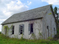
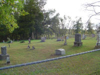
| Memorials | : | 9 |
| Location | : | High Point, Moniteau County, USA |
| Coordinate | : | 38.5196390, -92.5994260 |
| Description | : | Located in Pilot Grove Township, Section 32, Range 44, Township 44. Directions to cemetery: Take Hwy 87 south from California or north from High Point to Derby Lake Rd. This will be roughly 8 miles south of California and 4-5 miles north of High Point. Take Derby Lake Rd west and follow it until coming to Union Ford Rd. When on Derby Lake, it will make a 90 degree left turn and then a quick 90 degree right turn. At this right turn, Union Ford Rd will go straight (south). The cemetery will be a short distance down Union Ford Rd... Read More |
frequently asked questions (FAQ):
-
Where is Union Christian Church Cemetery?
Union Christian Church Cemetery is located at High Point, Moniteau County ,Missouri ,USA.
-
Union Christian Church Cemetery cemetery's updated grave count on graveviews.com?
9 memorials
-
Where are the coordinates of the Union Christian Church Cemetery?
Latitude: 38.5196390
Longitude: -92.5994260
Nearby Cemetories:
1. Yarnell Cemetery
California, Moniteau County, USA
Coordinate: 38.5189018, -92.5708008
2. United Baptist Church Cemetery
High Point, Moniteau County, USA
Coordinate: 38.4962200, -92.5856800
3. Gamble Cemetery
California, Moniteau County, USA
Coordinate: 38.5393982, -92.5757980
4. Old Latham Cemetery
Latham, Moniteau County, USA
Coordinate: 38.5466400, -92.5891100
5. Elliott Cemetery
Moniteau County, USA
Coordinate: 38.5244500, -92.6408700
6. Marney Family Cemetery
High Point, Moniteau County, USA
Coordinate: 38.5357900, -92.5614500
7. High Point Cemetery
High Point, Moniteau County, USA
Coordinate: 38.4817009, -92.5757980
8. Depp Cemetery
High Point, Moniteau County, USA
Coordinate: 38.4776400, -92.5818500
9. Pleasant Hill Cemetery
Moniteau County, USA
Coordinate: 38.5329500, -92.6590800
10. Norman Cemetery
High Point, Moniteau County, USA
Coordinate: 38.5681700, -92.5691300
11. Sappington Community Chapel Cemetery
California, Moniteau County, USA
Coordinate: 38.5770500, -92.6026700
12. Karnes Cemetery
Corticelli, Moniteau County, USA
Coordinate: 38.5099700, -92.5247900
13. DeFoe Cemetery
California, Moniteau County, USA
Coordinate: 38.5416985, -92.5250015
14. Latham Cemetery
Latham, Moniteau County, USA
Coordinate: 38.5643997, -92.6680984
15. Spring Hill Mennonite Cemetery
Latham, Moniteau County, USA
Coordinate: 38.5537900, -92.6824100
16. Phillips Cemetery
High Point, Moniteau County, USA
Coordinate: 38.4430300, -92.6125300
17. Gray Cemetery
Moniteau County, USA
Coordinate: 38.4536018, -92.5456009
18. Karnes-Carney-Henderson Cemetery
Burris Fork, Moniteau County, USA
Coordinate: 38.4992100, -92.5007510
19. Highland Cemetery
Moniteau County, USA
Coordinate: 38.5400009, -92.7003021
20. Bruce-Lewis-McGahan Cemetery
Enon, Moniteau County, USA
Coordinate: 38.4667500, -92.5172100
21. Rock Enon Cemetery
Miller County, USA
Coordinate: 38.4668400, -92.5170700
22. Brown Family Cemetery
California, Moniteau County, USA
Coordinate: 38.5862100, -92.5308800
23. Flag Spring Cemetery
California, Moniteau County, USA
Coordinate: 38.6102900, -92.6187800
24. Jackson Chapel Methodist Church Cemetery
California, Moniteau County, USA
Coordinate: 38.4447900, -92.5286500


