
| Memorials | : | 16 |
| Location | : | Webster County, USA |
| Coordinate | : | 42.3177986, -93.9421997 |
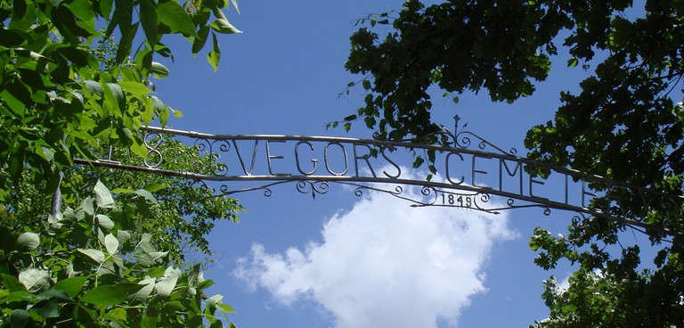
| Description | : | This is a confusing cemetery because of it's proximity to the county line. Most people probably associate it with the town of Homer (which is in Hamilton County). However the cemetery (which is 1 mile east and 3 1/2 south of Homer) is actually in Webster County. History: From about 500 B.C. to about 1200 A.D. the people who inhabited the region often laid their dead on a hilltop and then piled dirt on top; thus creating a mound of earth. When the early white settlers decided that this hilltop overlooking the Des Moines river would be a nice place... Read More |
frequently asked questions (FAQ):
-
Where is Vegors Cemetery?
Vegors Cemetery is located at Webster County ,Iowa ,USA.
-
Vegors Cemetery cemetery's updated grave count on graveviews.com?
10 memorials
-
Where are the coordinates of the Vegors Cemetery?
Latitude: 42.3177986
Longitude: -93.9421997
Nearby Cemetories:
1. Hooks Point Cemetery
Hamilton County, USA
Coordinate: 42.2944530, -93.9199090
2. Oakwood Cemetery
Stratford, Hamilton County, USA
Coordinate: 42.2942009, -93.9182968
3. Neese Cemetery
Homer, Hamilton County, USA
Coordinate: 42.3250000, -93.8935000
4. Nesse Cemetery
Hamilton County, USA
Coordinate: 42.3250008, -93.8933029
5. McGuire Bend Cemetery
Dayton, Webster County, USA
Coordinate: 42.3410000, -93.9880000
6. Homer Cemetery
Homer, Hamilton County, USA
Coordinate: 42.3680992, -93.9088974
7. Hartman Cemetery
Lehigh, Webster County, USA
Coordinate: 42.3666397, -93.9835627
8. Bass Cemetery
Dayton, Webster County, USA
Coordinate: 42.2966995, -94.0149994
9. Ober and Scott Cemetery
Duncombe, Webster County, USA
Coordinate: 42.3841390, -93.9982856
10. Hardin Township Cemetery
Hardin Township, Webster County, USA
Coordinate: 42.2411003, -93.9708023
11. Oak Grove Cemetery
Lehigh, Webster County, USA
Coordinate: 42.3438988, -94.0475006
12. Blanchard Cemetery
Webster County, USA
Coordinate: 42.4021988, -93.9997025
13. South Marion Cemetery
Stratford, Hamilton County, USA
Coordinate: 42.2327995, -93.8735962
14. Saratoga Cemetery
Stanhope, Hamilton County, USA
Coordinate: 42.3539009, -93.8167038
15. West Lawn Cemetery
Lehigh, Webster County, USA
Coordinate: 42.3616982, -94.0678024
16. Border Plains Cemetery
Border Plains, Webster County, USA
Coordinate: 42.3917000, -94.0448000
17. Dayton Cemetery
Dayton, Webster County, USA
Coordinate: 42.2675000, -94.0755000
18. Christ the King Catholic Cemetery
Dayton, Webster County, USA
Coordinate: 42.2601929, -94.0727539
19. Washington Cemetery
Duncombe, Webster County, USA
Coordinate: 42.4277992, -93.9916992
20. Linn Cemetery
Pilot Mound, Boone County, USA
Coordinate: 42.2045330, -93.9970230
21. White Cemetery
Boone County, USA
Coordinate: 42.1777992, -93.9636002
22. Zion Cemetery
Kamrar, Hamilton County, USA
Coordinate: 42.3544006, -93.7572021
23. Lawn Hill Cemetery
Stanhope, Hamilton County, USA
Coordinate: 42.2677994, -93.7611008
24. Mineral Ridge Cemetery
Ridgeport, Boone County, USA
Coordinate: 42.1749992, -93.9266968