
| Memorials | : | 0 |
| Location | : | De Haan, Arrondissement Oostende, Belgium |
| Coordinate | : | 51.2550900, 3.0561100 |
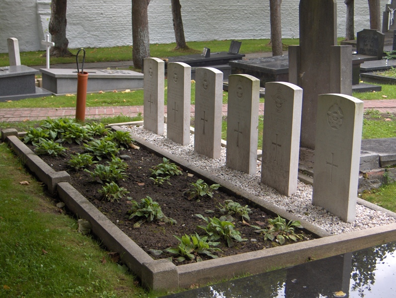
| Description | : | Location Information: Vlissegem Churchyard is located 10 Km east of Oostende on the Vijfwegestraat, a road leading from the N9 connecting Oostende to Brugge. From Oostende the N9 begins at Sas Slijkens and continues for 8 km to the left hand junction with Vijfewegestraat. 2 km along Vijfewegestraat lies the village of Vlissegem. The churchyard itself is located on the Dorpsplaats in the centre of the village. Historical Information: The British Expeditionary Force was involved in the later stages of the defence of Belgium following the German invasion in May 1940, and suffered many casualties in covering the withdrawal to Dunkirk.... Read More |
frequently asked questions (FAQ):
-
Where is Vlissegem Churchyard?
Vlissegem Churchyard is located at De Haan, Arrondissement Oostende ,West Flanders (West-Vlaanderen) ,Belgium.
-
Vlissegem Churchyard cemetery's updated grave count on graveviews.com?
0 memorials
-
Where are the coordinates of the Vlissegem Churchyard?
Latitude: 51.2550900
Longitude: 3.0561100
Nearby Cemetories:
1. Klemskerke Gemeentelijke Begraafplaats
De Haan, Arrondissement Oostende, Belgium
Coordinate: 51.2426300, 3.0243600
2. Nieuwmunster Churchyard
Zuienkerke, Arrondissement Brugge, Belgium
Coordinate: 51.2738400, 3.0984200
3. Houtave Churchyard
Zuienkerke, Arrondissement Brugge, Belgium
Coordinate: 51.2362700, 3.1104300
4. Wenduine Communal Cemetery
De Haan, Arrondissement Oostende, Belgium
Coordinate: 51.2912580, 3.0892830
5. Stalhille Churchyard
Jabbeke, Arrondissement Brugge, Belgium
Coordinate: 51.2144800, 3.0716400
6. Bredene Churchyard
Bredene, Arrondissement Oostende, Belgium
Coordinate: 51.2350860, 2.9770370
7. Blankenberge Communal Cemetery
Blankenberge, Arrondissement Brugge, Belgium
Coordinate: 51.3069010, 3.1289580
8. Oudenburg Communal Cemetery
Oudenburg, Arrondissement Oostende, Belgium
Coordinate: 51.1848310, 3.0192660
9. Jabbeke Sint-Blasius Churchyard
Jabbeke, Arrondissement Brugge, Belgium
Coordinate: 51.1826300, 3.0930300
10. Jabbeke Communal Cemetery
Jabbeke, Arrondissement Brugge, Belgium
Coordinate: 51.1710467, 3.0853816
11. Brugge Blauwe Toren Communal Cemetery
Bruges, Arrondissement Brugge, Belgium
Coordinate: 51.2548520, 3.1942320
12. Saint Peter and Saint Paul Church
Ostend, Arrondissement Oostende, Belgium
Coordinate: 51.2296200, 2.9211600
13. Sint-Amandus Church
Bekegem, Arrondissement Oostende, Belgium
Coordinate: 51.1597600, 3.0457000
14. Sint-Andries Churchyard
Bruges, Arrondissement Brugge, Belgium
Coordinate: 51.1969503, 3.1793477
15. Sint Pieters Churchyard
Bruges, Arrondissement Brugge, Belgium
Coordinate: 51.2295570, 3.2056260
16. Sint-Andries Communal Cemetery
Bruges, Arrondissement Brugge, Belgium
Coordinate: 51.1952670, 3.1798120
17. Westkerke Cemetery
Oudenburg, Arrondissement Oostende, Belgium
Coordinate: 51.1587181, 3.0190193
18. Westkerke Churchyard
Oudenburg, Arrondissement Oostende, Belgium
Coordinate: 51.1585500, 3.0192700
19. Oostende New Communal Cemetery
Ostend, Arrondissement Oostende, Belgium
Coordinate: 51.2093030, 2.9152390
20. Stene Communal Cemetery
Ostend, Arrondissement Oostende, Belgium
Coordinate: 51.2016500, 2.9169000
21. Gistel Communal Cemetery
Gistel, Arrondissement Oostende, Belgium
Coordinate: 51.1600400, 2.9836700
22. Oostende Old Communal Cemetery
Ostend, Arrondissement Oostende, Belgium
Coordinate: 51.2188200, 2.8956200
23. Dudzele Communal Churchyard
Bruges, Arrondissement Brugge, Belgium
Coordinate: 51.2748570, 3.2277270
24. Snaaskerke Churchyard
Gistel, Arrondissement Oostende, Belgium
Coordinate: 51.1746500, 2.9372700