
| Memorials | : | 0 |
| Location | : | Creeklocks, Ulster County, USA |
| Coordinate | : | 41.8705597, -74.0444412 |
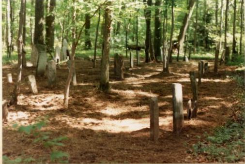
| Description | : | The Wagendahl Cemetery at Creek Locks is located atop a very steep hill at the northwest side of the intersection of Main Street and Creek Locks Road in Bloomington. Access to the property is possible only by climbing from the roadside to the top of the hill. In historical records there are many spellings of the area known as Wagendahl. In 1990 Carl Van Wagenen spent four weeks at the abandoned cemetery, clearing brush and debris, cutting down trees until he was able to search for and recover the gravestones that were scattered and buried everywhere. Many of the gravestones were... Read More |
frequently asked questions (FAQ):
-
Where is Wagendahl Cemetery?
Wagendahl Cemetery is located at Creeklocks, Ulster County ,New York ,USA.
-
Wagendahl Cemetery cemetery's updated grave count on graveviews.com?
0 memorials
-
Where are the coordinates of the Wagendahl Cemetery?
Latitude: 41.8705597
Longitude: -74.0444412
Nearby Cemetories:
1. Snyder-Van Wagenen Family Ground
Bloomington, Ulster County, USA
Coordinate: 41.8763800, -74.0416740
2. Bloomington Dutch Reformed Church Ground
Bloomington, Ulster County, USA
Coordinate: 41.8784600, -74.0445700
3. Lefever Cemetery
Bloomington, Ulster County, USA
Coordinate: 41.8778000, -74.0524979
4. Hardenburgh Ground
Bloomington, Ulster County, USA
Coordinate: 41.8640700, -74.0596500
5. LeFevre Family Ground
Tillson, Ulster County, USA
Coordinate: 41.8531580, -74.0511470
6. Saint Remy Cemetery
Saint Remy, Ulster County, USA
Coordinate: 41.8838425, -74.0223999
7. Eddyville Cemetery
Eddyville, Ulster County, USA
Coordinate: 41.8936155, -74.0224689
8. Rifton Community Ground
Rifton, Ulster County, USA
Coordinate: 41.8418000, -74.0384000
9. Saint Remy Slave Cemetery
Saint Remy, Ulster County, USA
Coordinate: 41.8924065, -74.0170135
10. Colonel Jacob Rutsen Ground
Rosendale, Ulster County, USA
Coordinate: 41.8477100, -74.0766500
11. Coutant Ground
Tillson, Ulster County, USA
Coordinate: 41.8305570, -74.0494220
12. Saint Peters Cemetery
Rosendale, Ulster County, USA
Coordinate: 41.8389015, -74.0832977
13. Friend's Cemetery
Tillson, Ulster County, USA
Coordinate: 41.8301200, -74.0654300
14. Rosendale Plains Cemetery
Tillson, Ulster County, USA
Coordinate: 41.8333015, -74.0789032
15. Tilson Ground-Rosendale Plains
Tillson, Ulster County, USA
Coordinate: 41.8318290, -74.0777810
16. Snyder Estate Cemetery
Rosendale, Ulster County, USA
Coordinate: 41.8426500, -74.0972900
17. Hurley Cemetery
Hurley, Ulster County, USA
Coordinate: 41.9212685, -74.0590820
18. Woodcrest Bruderhof Cemetery
Rifton, Ulster County, USA
Coordinate: 41.8188395, -74.0522381
19. Freer Burial Ground
Tillson, Ulster County, USA
Coordinate: 41.8182500, -74.0609900
20. Freer Ground
Rifton, Ulster County, USA
Coordinate: 41.8182500, -74.0609900
21. Marbletown Cemetery
Marbletown, Ulster County, USA
Coordinate: 41.8784218, -74.1158981
22. Mount Zion Cemetery
Kingston, Ulster County, USA
Coordinate: 41.9184900, -74.0116300
23. Deyo Burying Ground
Springtown, Ulster County, USA
Coordinate: 41.8177900, -74.0625000
24. Old Hurley Burial Ground
Hurley, Ulster County, USA
Coordinate: 41.9264183, -74.0629272