
| Memorials | : | 0 |
| Location | : | Roy, Weber County, USA |
| Coordinate | : | 41.1613200, -112.0458700 |
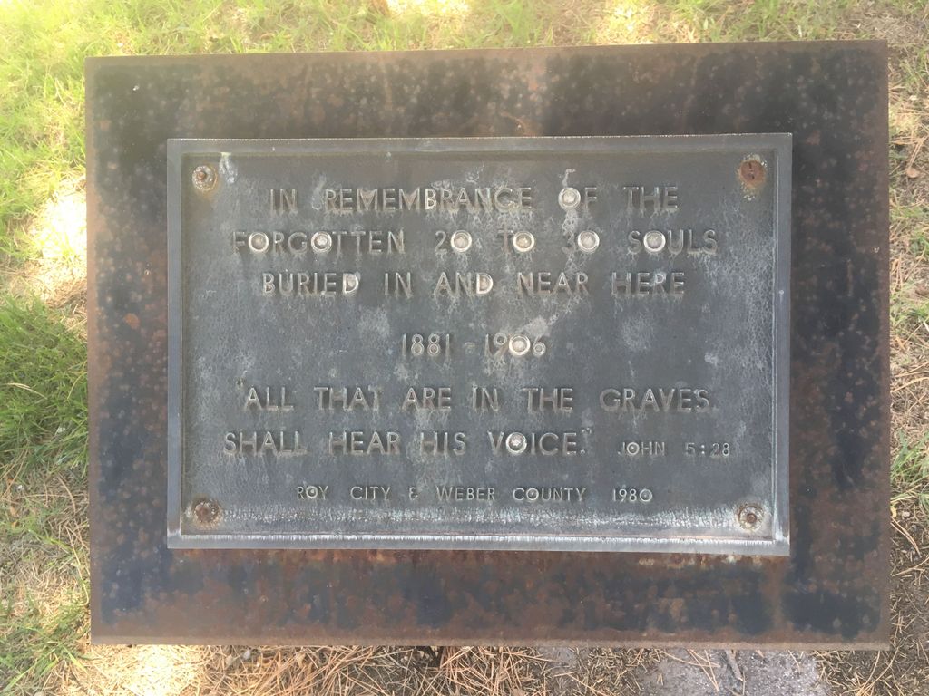
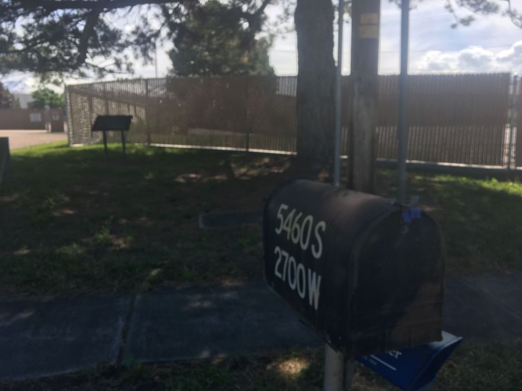
| Description | : | In 1980 a plaque was placed at the cemetery in hopes of preserving and remembering those who were buried there. A contractor bought the property and was going to build on it without moving those interred there. The plaque was relocated to 5460 S 2700 W. As of February 1, 2014 nothing has been built on the property. There are no markers or visible signs that this vacant property is a cemetery. |
frequently asked questions (FAQ):
-
Where is Weber County Poor Farm Cemetery?
Weber County Poor Farm Cemetery is located at Roy, Weber County ,Utah ,USA.
-
Weber County Poor Farm Cemetery cemetery's updated grave count on graveviews.com?
0 memorials
-
Where are the coordinates of the Weber County Poor Farm Cemetery?
Latitude: 41.1613200
Longitude: -112.0458700
Nearby Cemetories:
1. Roy City Cemetery
Roy, Weber County, USA
Coordinate: 41.1680984, -112.0353012
2. Clinton City Cemetery
Clinton, Davis County, USA
Coordinate: 41.1260986, -112.0402985
3. Washington Heights Memorial Park
South Ogden, Weber County, USA
Coordinate: 41.1779900, -111.9700600
4. South Weber Cemetery
South Weber, Davis County, USA
Coordinate: 41.1425018, -111.9693985
5. West Point Cemetery
West Point, Davis County, USA
Coordinate: 41.1142006, -112.0997009
6. Hooper City Cemetery
Hooper, Weber County, USA
Coordinate: 41.1666985, -112.1306000
7. Syracuse Cemetery
Syracuse, Davis County, USA
Coordinate: 41.0960999, -112.0456009
8. Clearfield City Cemetery
Clearfield, Davis County, USA
Coordinate: 41.0983009, -112.0102997
9. Aultorest Memorial Park
Ogden, Weber County, USA
Coordinate: 41.2005997, -111.9610977
10. West Haven Cemetery
West Haven, Weber County, USA
Coordinate: 41.2388900, -112.0363000
11. Uintah Cemetery
Uintah, Weber County, USA
Coordinate: 41.1458015, -111.9421997
12. Layton Hill Cemetery
Layton, Davis County, USA
Coordinate: 41.0988000, -111.9746300
13. Good Shepherd Columbarium
Ogden, Weber County, USA
Coordinate: 41.2231000, -111.9731000
14. Lindquists Memorial Gardens of the Wasatch
South Ogden, Weber County, USA
Coordinate: 41.1631012, -111.9321976
15. Ogden City Cemetery
Ogden, Weber County, USA
Coordinate: 41.2324982, -111.9621964
16. Tiffany Mack Memorial Pet Cemetery
Ogden, Weber County, USA
Coordinate: 41.2342300, -111.9600900
17. Lindquist Memorial Park
Layton, Davis County, USA
Coordinate: 41.0869210, -111.9504260
18. West Weber Cemetery
West Weber, Weber County, USA
Coordinate: 41.2757988, -112.0875015
19. Evergreen Memorial Park
Ogden, Weber County, USA
Coordinate: 41.2639210, -111.9583230
20. Warren Cemetery
Warren, Weber County, USA
Coordinate: 41.2728004, -112.1402969
21. Plain City Cemetery
Plain City, Weber County, USA
Coordinate: 41.2943993, -112.0847015
22. Adams Gravesite
Layton, Davis County, USA
Coordinate: 41.0668880, -111.9099400
23. Kaysville City Cemetery
Kaysville, Davis County, USA
Coordinate: 41.0449982, -111.9263992
24. Ben Lomond Cemetery
North Ogden, Weber County, USA
Coordinate: 41.3133011, -111.9646988