
| Memorials | : | 1 |
| Location | : | Dennison, Tuscarawas County, USA |
| Coordinate | : | 40.4301530, -81.3057300 |
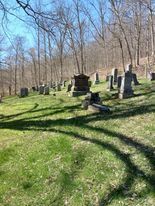
| Description | : | The cemetery is located on the south side of Hilltop Road SE (Township Road 301) about 150 feet west of its junction with Irish Run Road SE (Township Road 299). The cemetery is located in Union Township, Tuscarawas County, Ohio, and is # 11896 (Wesley Chapel Cemetery) in “Ohio Cemeteries 1803-2003”, compiled by the Ohio Genealogical Society. The U.S. Geological Survey (USGS) Geographic Names Information System (GNIS) feature ID for the cemetery is 1963872 (Wesley Chapel Cemetery). |
frequently asked questions (FAQ):
-
Where is Wesley Chapel Cemetery?
Wesley Chapel Cemetery is located at 7798 Hilltop Road SE (Township Road 301) Dennison, Tuscarawas County ,Ohio , 44621USA.
-
Wesley Chapel Cemetery cemetery's updated grave count on graveviews.com?
1 memorials
-
Where are the coordinates of the Wesley Chapel Cemetery?
Latitude: 40.4301530
Longitude: -81.3057300
Nearby Cemetories:
1. Pleasant Valley Cemetery
Dennison, Tuscarawas County, USA
Coordinate: 40.4152800, -81.2858300
2. Boone Family Cemetery
Tuscarawas County, USA
Coordinate: 40.4112100, -81.2899700
3. Kelley Family Cemetery
Dennison, Tuscarawas County, USA
Coordinate: 40.4214600, -81.3386260
4. Calvary Cemetery
Dennison, Tuscarawas County, USA
Coordinate: 40.3997002, -81.3289032
5. Saint Marys Cemetery
Dennison, Tuscarawas County, USA
Coordinate: 40.4202995, -81.3510971
6. Lytle Cemetery
Dennison, Tuscarawas County, USA
Coordinate: 40.3944463, -81.2989310
7. Roxford Church Cemetery
Tuscarawas County, USA
Coordinate: 40.4703400, -81.3087200
8. Liberty Cemetery
Tuscarawas County, USA
Coordinate: 40.3835983, -81.2932968
9. Mount Bethel United Brethren Church Cemetery
Dennison, Tuscarawas County, USA
Coordinate: 40.3896100, -81.2718340
10. Union Cemetery
Uhrichsville, Tuscarawas County, USA
Coordinate: 40.3953018, -81.3518982
11. Saint Elizabeth Cemetery
Roswell, Tuscarawas County, USA
Coordinate: 40.4768982, -81.3427963
12. Roswell United Brethren Cemetery
Roswell, Tuscarawas County, USA
Coordinate: 40.4782780, -81.3543100
13. Sherrodsville Memorial Gardens Cemetery
Sherrodsville, Carroll County, USA
Coordinate: 40.4852982, -81.2675018
14. Tunnel Hill Cemetery
Bowerston, Harrison County, USA
Coordinate: 40.4213982, -81.2238998
15. Sherrodsville Cemetery
Sherrodsville, Carroll County, USA
Coordinate: 40.4836006, -81.2544022
16. Wardell Cemetery
Uhrichsville, Tuscarawas County, USA
Coordinate: 40.3758100, -81.3659600
17. Plum Run Hill Top Cemetery
Harrison County, USA
Coordinate: 40.3814011, -81.2324982
18. Ridge Road Cemetery
Tuscarawas County, USA
Coordinate: 40.4797250, -81.3791320
19. Plum Run Cemetery
Bowerston, Harrison County, USA
Coordinate: 40.3819008, -81.2294006
20. Leesville Cemetery
Leesville, Carroll County, USA
Coordinate: 40.4550018, -81.2114029
21. Newport Methodist Cemetery
Newport, Tuscarawas County, USA
Coordinate: 40.3591995, -81.3450012
22. Holmes Methodist Episcopal Cemetery
Goshen, Tuscarawas County, USA
Coordinate: 40.5056200, -81.3392800
23. Heller Cemetery
Bowerston, Harrison County, USA
Coordinate: 40.4089012, -81.2043991
24. Zeisberger Memorial Cemetery
Goshen, Tuscarawas County, USA
Coordinate: 40.4430440, -81.4110770