
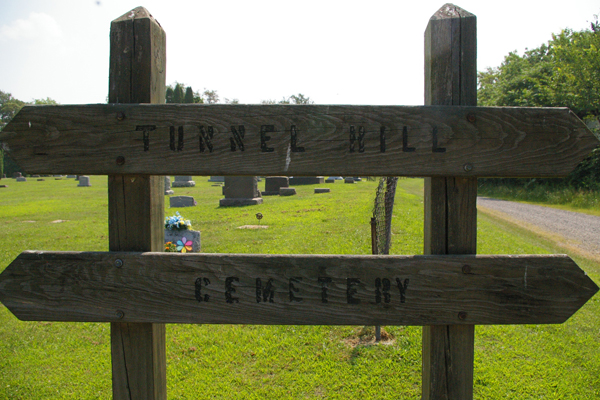
| Memorials | : | 604 |
| Location | : | Bowerston, Harrison County, USA |
| Coordinate | : | 40.4213982, -81.2238998 |
frequently asked questions (FAQ):
-
Where is Tunnel Hill Cemetery?
Tunnel Hill Cemetery is located at Bowerston, Harrison County ,Ohio ,USA.
-
Tunnel Hill Cemetery cemetery's updated grave count on graveviews.com?
604 memorials
-
Where are the coordinates of the Tunnel Hill Cemetery?
Latitude: 40.4213982
Longitude: -81.2238998
Nearby Cemetories:
1. Heller Cemetery
Bowerston, Harrison County, USA
Coordinate: 40.4089012, -81.2043991
2. Longview Cemetery
Bowerston, Harrison County, USA
Coordinate: 40.4324989, -81.1872025
3. Leesville Cemetery
Leesville, Carroll County, USA
Coordinate: 40.4550018, -81.2114029
4. New Hagerstown Cemetery
New Hagerstown, Carroll County, USA
Coordinate: 40.4446983, -81.1893997
5. Plum Run Cemetery
Bowerston, Harrison County, USA
Coordinate: 40.3819008, -81.2294006
6. Plum Run Hill Top Cemetery
Harrison County, USA
Coordinate: 40.3814011, -81.2324982
7. Swinehart Cemetery
Carroll County, USA
Coordinate: 40.4327000, -81.1642170
8. Pleasant Valley Cemetery
Dennison, Tuscarawas County, USA
Coordinate: 40.4152800, -81.2858300
9. Mount Bethel United Brethren Church Cemetery
Dennison, Tuscarawas County, USA
Coordinate: 40.3896100, -81.2718340
10. Boone Family Cemetery
Tuscarawas County, USA
Coordinate: 40.4112100, -81.2899700
11. Conotton Cemetery
Harrison County, USA
Coordinate: 40.4103012, -81.1489029
12. Beaver Valley Cemetery
Monroe Township, Harrison County, USA
Coordinate: 40.3779100, -81.1703860
13. Wesley Chapel Cemetery
Dennison, Tuscarawas County, USA
Coordinate: 40.4301530, -81.3057300
14. Lytle Cemetery
Dennison, Tuscarawas County, USA
Coordinate: 40.3944463, -81.2989310
15. Tappan Cemetery
Harrison County, USA
Coordinate: 40.3581009, -81.2078018
16. Liberty Cemetery
Tuscarawas County, USA
Coordinate: 40.3835983, -81.2932968
17. Sherrodsville Cemetery
Sherrodsville, Carroll County, USA
Coordinate: 40.4836006, -81.2544022
18. Mount Olive Cemetery
Carroll County, USA
Coordinate: 40.4488983, -81.1382980
19. Sherrodsville Memorial Gardens Cemetery
Sherrodsville, Carroll County, USA
Coordinate: 40.4852982, -81.2675018
20. Mount Zion African Methodist Episcopal Cemetery
Conotton, Harrison County, USA
Coordinate: 40.3598990, -81.1733160
21. Veteran's Grave
Orange Township, Carroll County, USA
Coordinate: 40.4931470, -81.2003677
22. Saint Francis Catholic Cemetery
Sherrodsville, Carroll County, USA
Coordinate: 40.4951920, -81.2349170
23. Feed Springs Cemetery
Feed Springs, Harrison County, USA
Coordinate: 40.3485100, -81.2543600
24. Bethel Cemetery
Leavittsville, Carroll County, USA
Coordinate: 40.4921989, -81.1841965