
| Memorials | : | 0 |
| Location | : | Tselakai Dezza, San Juan County, USA |
| Phone | : | -109.605591 |
| Coordinate | : | 37.2237010, -109.6055910 |
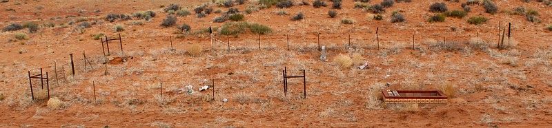
| Description | : | Directions: at the junction of US 163 and US 191, turn SOUTH on US 191 for 3.6 miles; then turn LEFT onto a dirt road (just before the White Rock Road sign on the right) for 0.6 miles Part of the wire cemetery fence has been rolled up, so the right side of the cemetery is un-fenced |
frequently asked questions (FAQ):
-
Where is White Rock Point Cemetery?
White Rock Point Cemetery is located at Mexican Water Road (US 191) Tselakai Dezza, San Juan County ,Utah , 37.223701USA.
-
White Rock Point Cemetery cemetery's updated grave count on graveviews.com?
0 memorials
-
Where are the coordinates of the White Rock Point Cemetery?
Latitude: 37.2237010
Longitude: -109.6055910

Nearby Cemetories:
1. Bluff Cemetery
Bluff, San Juan County, USA
Coordinate: 37.2877998, -109.5541992
2. Saint Christophers Cemetery
Bluff, San Juan County, USA
Coordinate: 37.2852700, -109.5128500
3. Sunrise Cemetery
San Juan County, USA
Coordinate: 37.0650200, -109.3772200
4. Red Mesa Community Cemetery
San Juan County, USA
Coordinate: 37.0650200, -109.3771100
5. Montezuma Creek Cemetery
San Juan County, USA
Coordinate: 37.2623000, -109.3047000
6. Mexican Water Community Cemetery
Mexican Water, Apache County, USA
Coordinate: 36.9710200, -109.6274600
7. White Mesa Village Cemetery
San Juan County, USA
Coordinate: 37.1630600, -109.2660900
8. Tes Nes Iah Cemetery
Apache County, USA
Coordinate: 36.9434300, -109.7091300
9. Aneth Area Burials
Aneth, San Juan County, USA
Coordinate: 37.2321000, -109.2131000
10. Blanding City Cemetery
Blanding, San Juan County, USA
Coordinate: 37.6307983, -109.4682999
11. Allen Canyon Ute Cemetery
Blanding, San Juan County, USA
Coordinate: 37.6595900, -109.6340300
12. Immanuel Mission Cemetery
Coyote Springs, Apache County, USA
Coordinate: 36.8033170, -109.3964770
13. Dennehotso Community Cemetery
Dennehotso, Apache County, USA
Coordinate: 36.8079090, -109.8884020
14. Monument Valley Cemetery
San Juan County, USA
Coordinate: 37.0266800, -110.1977300
15. Teec Nos Pos Cemetery
Teec Nos Pos, Apache County, USA
Coordinate: 36.9208890, -109.0867170
16. Harry Hopkins Gravesite
San Juan County, USA
Coordinate: 37.7830010, -109.4367980
17. Verdure Cemetery
Verdure, San Juan County, USA
Coordinate: 37.7837000, -109.3461000
18. Urado Cemetery
San Juan County, USA
Coordinate: 37.6459000, -109.0590000
19. Beclabito Cemetery
Beclabito, San Juan County, USA
Coordinate: 36.8328400, -109.0115300
20. McElmo Cemetery
Montezuma County, USA
Coordinate: 37.3374405, -108.8397980
21. Battlerock Cemetery
Montezuma County, USA
Coordinate: 37.3375000, -108.8395000
22. Cedar Point Cemetery
San Juan County, USA
Coordinate: 37.7057000, -109.0819000
23. Lamb Cemetery
Montezuma County, USA
Coordinate: 37.3418999, -108.8099976
24. Soldier Crossing Cemetery
Fry Canyon, San Juan County, USA
Coordinate: 37.6851900, -110.2195600