
| Memorials | : | 0 |
| Location | : | Grantsville, Garrett County, USA |
| Coordinate | : | 39.6855900, -79.1663600 |
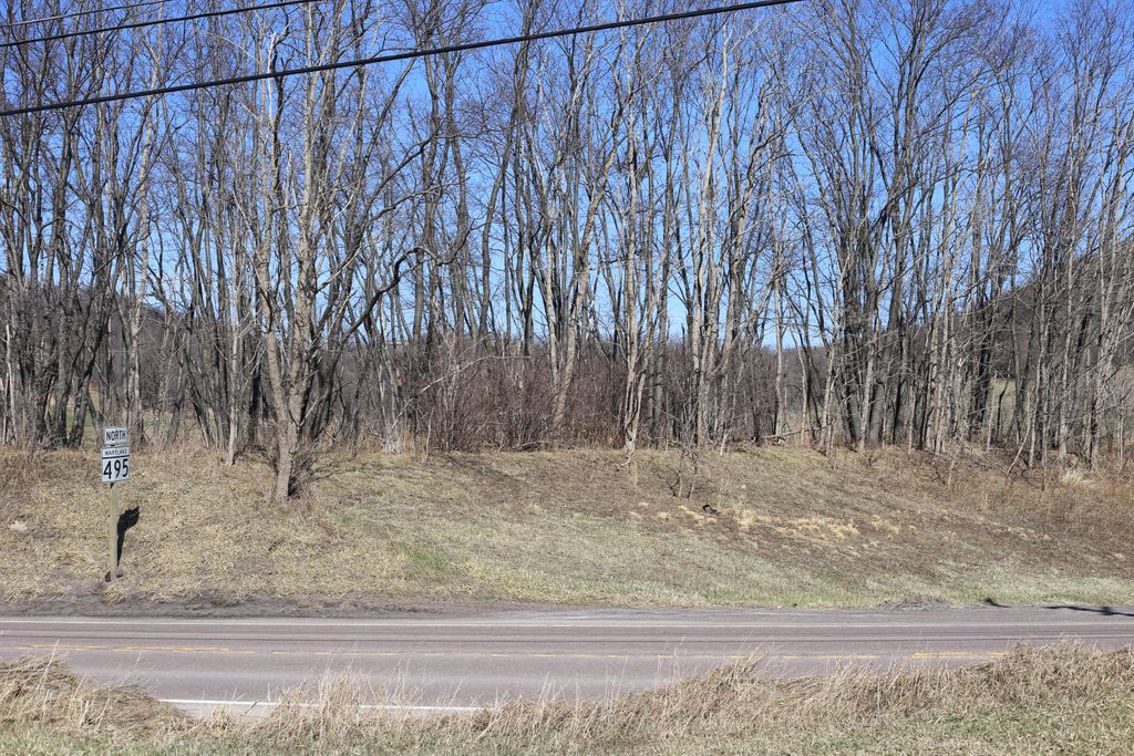
| Description | : | From (The Bittinger-Bittner, Biddinger and Bidinger families and their Kin of Garrett County, Md.) by Wayne Bittinger. A private cemetery is located on the former Wiland property at Miller Hill. This cemetery is situated on a little knob beside maryland Route 495--on the east side of the road, just before it crosses (going southward) over Shade Run. None of the graves are marked with carved stones, but Leslie J. Stanton was told that "a Wiland and his wife" were buried there. |
frequently asked questions (FAQ):
-
Where is Wiland Farm Cemetery?
Wiland Farm Cemetery is located at Grantsville, Garrett County ,Maryland ,USA.
-
Wiland Farm Cemetery cemetery's updated grave count on graveviews.com?
0 memorials
-
Where are the coordinates of the Wiland Farm Cemetery?
Latitude: 39.6855900
Longitude: -79.1663600
Nearby Cemetories:
1. Grantsville Cemetery
Grantsville, Garrett County, USA
Coordinate: 39.6949997, -79.1641998
2. Otto Cemetery
Jennings, Garrett County, USA
Coordinate: 39.6772970, -79.1577550
3. Maple Grove Cemetery
Jennings, Garrett County, USA
Coordinate: 39.6737800, -79.1627000
4. Custer Cemetery
Garrett County, USA
Coordinate: 39.6720990, -79.1497030
5. Engle Cemetery
Grantsville, Garrett County, USA
Coordinate: 39.6656860, -79.1549920
6. Maple Glen Cemetery
Grantsville, Garrett County, USA
Coordinate: 39.7061005, -79.1511002
7. Eli Ridgeley Amish Cemetery
Garrett County, USA
Coordinate: 39.6662800, -79.1861300
8. Negro Mountain Cemetery
Garrett County, USA
Coordinate: 39.6697006, -79.2118988
9. Laughlin Church Cemetery
Grantsville, Garrett County, USA
Coordinate: 39.6702400, -79.2125900
10. Amos J. Yoder Old Burial Ground
Elk Lick Township, Somerset County, USA
Coordinate: 39.7256000, -79.1539000
11. Oak Grove Mennonite Cemetery
Garrett County, USA
Coordinate: 39.7096550, -79.2110820
12. Davies Family Cemetery
Grantsville, Garrett County, USA
Coordinate: 39.6770100, -79.1064200
13. Wilburn Cemetery
Jennings, Garrett County, USA
Coordinate: 39.6397200, -79.1937000
14. Beachy Grave Yard
Elk Lick Township, Somerset County, USA
Coordinate: 39.7283000, -79.1274000
15. Jesse Tomlinson Cemetery
Grantsville, Garrett County, USA
Coordinate: 39.6995620, -79.0961020
16. Hershberger Graveyard
Elk Lick Township, Somerset County, USA
Coordinate: 39.7380680, -79.1311060
17. Niverton Amish Cemetery
Niverton, Somerset County, USA
Coordinate: 39.7368340, -79.1257480
18. Ringer-Shoemaker Cemetery
Fort Hill, Somerset County, USA
Coordinate: 39.7418530, -79.2101170
19. Mount Beulah Methodist Church Cemetery
Garrett County, USA
Coordinate: 39.6376200, -79.1058100
20. Trinity Cemetery
Grantsville, Garrett County, USA
Coordinate: 39.6380997, -79.1050034
21. New Germany Methodist Cemetery
Grantsville, Garrett County, USA
Coordinate: 39.6382600, -79.1044400
22. Dung Hill Cemetery
Garrett County, USA
Coordinate: 39.6302986, -79.2316971
23. Christner Farm Cemetery
Elk Lick Township, Somerset County, USA
Coordinate: 39.7519440, -79.1202780
24. Merrbach Cemetery
Garrett County, USA
Coordinate: 39.6893997, -79.0674973