
| Memorials | : | 0 |
| Location | : | Goderich Township, Huron County, Canada |
| Coordinate | : | 43.7596580, -81.7041050 |
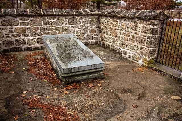
| Description | : | The small park and stone-walled tomb enclosure are the last remnant of Gairbraid, the 845-acre estate acquired from the Canada Company in 1833 by Dr. William "Tiger" Dunlop and his brother Captain Robert Dunlop, Royal Navy From Highway 21 north of Goderich (Town of Goderich, County of Huron, Ontario), turn left (west) onto Airport Road, then almost immediately left (south) onto River Ridge Crescent. Follow this street to an end-of-road yellow and black diamond marker. Turn left at the diamond, go down a hill, and park your vehicle. Walk around a gate, then left onto a rail-trail. Follow... Read More |
frequently asked questions (FAQ):
-
Where is William Dunlop Tomb?
William Dunlop Tomb is located at Tomb Road, off Airport Road (#27) at the Bluewater Highway (#21) Goderich Township, Huron County ,Ontario ,Canada.
-
William Dunlop Tomb cemetery's updated grave count on graveviews.com?
0 memorials
-
Where are the coordinates of the William Dunlop Tomb?
Latitude: 43.7596580
Longitude: -81.7041050
Nearby Cemetories:
1. Saint Peter's Catholic Cemetery
Colborne Township, Huron County, Canada
Coordinate: 43.7397360, -81.6761940
2. Colborne Cemetery
Colborne Township, Huron County, Canada
Coordinate: 43.7410880, -81.6727070
3. Maitland Cemetery
Goderich Township, Huron County, Canada
Coordinate: 43.7273200, -81.6850300
4. Varcoe Memorial Cemetery
Colborne Township, Huron County, Canada
Coordinate: 43.7800120, -81.6498520
5. Colborne Evangelical Cemetery
Colborne Township, Huron County, Canada
Coordinate: 43.7213800, -81.5891380
6. Dungannon Cemetery
Dungannon, Huron County, Canada
Coordinate: 43.8572542, -81.6097069
7. Christ Church Anglican Cemetery
Ashfield Township, Huron County, Canada
Coordinate: 43.8788446, -81.7112518
8. Ball's Cemetery
Hullett Township, Huron County, Canada
Coordinate: 43.7344320, -81.5418630
9. Holmesville Memorial Cemetery
Holmesville, Huron County, Canada
Coordinate: 43.6493090, -81.6074690
10. Hope Chapel Cemetery
Central Huron Township, Huron County, Canada
Coordinate: 43.7297610, -81.5031730
11. German Evangelical Lutheran Cemetery
Hullett Township, Huron County, Canada
Coordinate: 43.7520530, -81.4856970
12. Westfield Methodist Cemetery
Westfield, Huron County, Canada
Coordinate: 43.7989500, -81.4854500
13. Saint Augustine Catholic Cemetery
Saint-Augustine, Huron County, Canada
Coordinate: 43.8415400, -81.5062400
14. Saint Joseph Catholic Cemetery
Kingsbridge, Huron County, Canada
Coordinate: 43.9298040, -81.7014390
15. Londesborough Cemetery
Londesborough, Huron County, Canada
Coordinate: 43.6977800, -81.4812200
16. Donnybrook Cemetery
Donnybrook, Huron County, Canada
Coordinate: 43.8367480, -81.4878700
17. Clinton Public Cemetery
Clinton, Huron County, Canada
Coordinate: 43.6351790, -81.5293200
18. Blyth Union Cemetery
Blyth, Huron County, Canada
Coordinate: 43.7300034, -81.4564743
19. Saint Joseph's Roman Catholic Cemetery
Hullett Township, Huron County, Canada
Coordinate: 43.6421190, -81.4980580
20. Hackett Family Burial Ground
Ashfield Township, Huron County, Canada
Coordinate: 43.9278200, -81.5710800
21. Blyth Anglican Potter's Historic Cemetery
Blyth, Huron County, Canada
Coordinate: 43.7441000, -81.4327200
22. Kintail Cemetery
Kintail, Huron County, Canada
Coordinate: 43.9595375, -81.7018890
23. Bayfield Cemetery
Bayfield, Huron County, Canada
Coordinate: 43.5584200, -81.6830700
24. Blyth Memorial Cairn
Blyth, Huron County, Canada
Coordinate: 43.7341580, -81.4242160