
| Memorials | : | 9 |
| Location | : | Canterbury, City of Canterbury, England |
| Coordinate | : | 51.2718430, 1.0672940 |
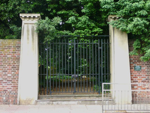
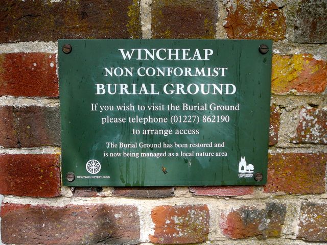
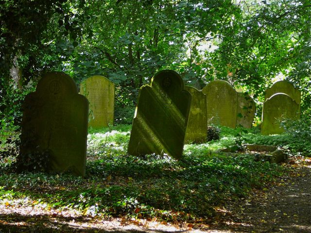
| Description | : | Wincheap Non-Conformist Burial Ground is surrounded by high brick walls, next to the King's Head public house on one of the busiest roads into Canterbury. It was established in 1849, and closed for burials in 1938. After this it became very overgrown and vandalised, until it was taken over by Canterbury City Council in 1976. It has since been restored, and is now managed as a nature reserve; the gates are kept locked and access is strictly regulated. (Text by Sheilia W.) |
frequently asked questions (FAQ):
-
Where is Wincheap Non-Conformist Burial Ground?
Wincheap Non-Conformist Burial Ground is located at Wincheap Canterbury, City of Canterbury ,Kent , CT1 3RYEngland.
-
Wincheap Non-Conformist Burial Ground cemetery's updated grave count on graveviews.com?
9 memorials
-
Where are the coordinates of the Wincheap Non-Conformist Burial Ground?
Latitude: 51.2718430
Longitude: 1.0672940
Nearby Cemetories:
1. St. Mildred with St. Mary de Castro Church
Canterbury, City of Canterbury, England
Coordinate: 51.2764810, 1.0743320
2. St Mary de Castro Churchyard
Canterbury, City of Canterbury, England
Coordinate: 51.2762400, 1.0766820
3. Dane John Gardens
Canterbury, City of Canterbury, England
Coordinate: 51.2754210, 1.0780390
4. St Nicholas Churchyard
Thanington-Without, City of Canterbury, England
Coordinate: 51.2703550, 1.0544190
5. Westgate Gardens
Canterbury, City of Canterbury, England
Coordinate: 51.2805250, 1.0745040
6. St Mary Bredin Old Church (Defunct)
Canterbury, City of Canterbury, England
Coordinate: 51.2773455, 1.0803962
7. St Margaret's Churchyard
Canterbury, City of Canterbury, England
Coordinate: 51.2781780, 1.0795840
8. St Peters Methodist Church
Canterbury, City of Canterbury, England
Coordinate: 51.2801720, 1.0771480
9. Holy Cross Church
Canterbury, City of Canterbury, England
Coordinate: 51.2811350, 1.0755710
10. St Mary Breadman Church Demolished
Canterbury, City of Canterbury, England
Coordinate: 51.2798870, 1.0784520
11. All Saints Church Demolished
Canterbury, City of Canterbury, England
Coordinate: 51.2802800, 1.0783450
12. St Peter the Apostle Churchyard
Canterbury, City of Canterbury, England
Coordinate: 51.2807260, 1.0775370
13. St George's Church Demolished
Canterbury, City of Canterbury, England
Coordinate: 51.2773770, 1.0827380
14. St Mary Magdalene Church Demolished
Canterbury, City of Canterbury, England
Coordinate: 51.2784510, 1.0830170
15. St. Dunstan Churchyard
Canterbury, City of Canterbury, England
Coordinate: 51.2836820, 1.0707800
16. Canterbury Cathedral
Canterbury, City of Canterbury, England
Coordinate: 51.2796936, 1.0826840
17. Canterbury City Cemetery
Canterbury, City of Canterbury, England
Coordinate: 51.2843285, 1.0637640
18. St Paul Without the Walls
Canterbury, City of Canterbury, England
Coordinate: 51.2779380, 1.0853180
19. St Michael and All Angels Church
Harbledown, City of Canterbury, England
Coordinate: 51.2824590, 1.0556800
20. Canterbury Jewish Cemetery
Canterbury, City of Canterbury, England
Coordinate: 51.2846135, 1.0706660
21. St Nicholas Hospital Church
Harbledown, City of Canterbury, England
Coordinate: 51.2828200, 1.0536580
22. St Augustine Abbey Ruins
Canterbury, City of Canterbury, England
Coordinate: 51.2781280, 1.0882060
23. St Mary Northgate Cemetery
Canterbury, City of Canterbury, England
Coordinate: 51.2811320, 1.0859300
24. St. John the Baptist Hospital Chapelyard
Canterbury, City of Canterbury, England
Coordinate: 51.2832713, 1.0837677