
| Memorials | : | 12 |
| Location | : | Canterbury, City of Canterbury, England |
| Coordinate | : | 51.2801720, 1.0771480 |
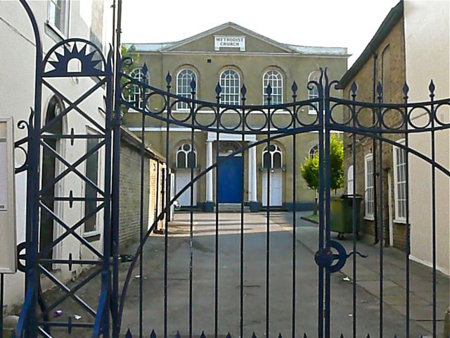
| Description | : | St Peter's Methodist Church was built in 1811, replacing an earlier chapel dating from 1764, to which John Wesley had been a frequent visitor. A table used by Wesley can still be seen in the present church. The interior is symmetrical, light and airy, in the style of John Nash, with some handsome plain panelling. The chapel had been noted for its lively choir and orchestra, and live music events continue to take place here. A graveyard was laid out in front of the building in 1828; in 1903 the gravestones were moved back in front of a wall. The surviving... Read More |
frequently asked questions (FAQ):
-
Where is St Peters Methodist Church?
St Peters Methodist Church is located at St Peter's Street Canterbury, City of Canterbury ,Kent , CT1 2BEEngland.
-
St Peters Methodist Church cemetery's updated grave count on graveviews.com?
12 memorials
-
Where are the coordinates of the St Peters Methodist Church?
Latitude: 51.2801720
Longitude: 1.0771480

Nearby Cemetories:
1. St Peter the Apostle Churchyard
Canterbury, City of Canterbury, England
Coordinate: 51.2807260, 1.0775370
2. All Saints Church Demolished
Canterbury, City of Canterbury, England
Coordinate: 51.2802800, 1.0783450
3. St Mary Breadman Church Demolished
Canterbury, City of Canterbury, England
Coordinate: 51.2798870, 1.0784520
4. Holy Cross Church
Canterbury, City of Canterbury, England
Coordinate: 51.2811350, 1.0755710
5. Westgate Gardens
Canterbury, City of Canterbury, England
Coordinate: 51.2805250, 1.0745040
6. St Margaret's Churchyard
Canterbury, City of Canterbury, England
Coordinate: 51.2781780, 1.0795840
7. St Mary Bredin Old Church (Defunct)
Canterbury, City of Canterbury, England
Coordinate: 51.2773455, 1.0803962
8. Canterbury Cathedral
Canterbury, City of Canterbury, England
Coordinate: 51.2796936, 1.0826840
9. St Mary de Castro Churchyard
Canterbury, City of Canterbury, England
Coordinate: 51.2762400, 1.0766820
10. St Mary Magdalene Church Demolished
Canterbury, City of Canterbury, England
Coordinate: 51.2784510, 1.0830170
11. St. Mildred with St. Mary de Castro Church
Canterbury, City of Canterbury, England
Coordinate: 51.2764810, 1.0743320
12. St George's Church Demolished
Canterbury, City of Canterbury, England
Coordinate: 51.2773770, 1.0827380
13. Dane John Gardens
Canterbury, City of Canterbury, England
Coordinate: 51.2754210, 1.0780390
14. St. John the Baptist Hospital Chapelyard
Canterbury, City of Canterbury, England
Coordinate: 51.2832713, 1.0837677
15. St. Dunstan Churchyard
Canterbury, City of Canterbury, England
Coordinate: 51.2836820, 1.0707800
16. St Mary Northgate Cemetery
Canterbury, City of Canterbury, England
Coordinate: 51.2811320, 1.0859300
17. St Paul Without the Walls
Canterbury, City of Canterbury, England
Coordinate: 51.2779380, 1.0853180
18. Canterbury Jewish Cemetery
Canterbury, City of Canterbury, England
Coordinate: 51.2846135, 1.0706660
19. St Gregory's Priory (defunct)
Canterbury, City of Canterbury, England
Coordinate: 51.2831127, 1.0855358
20. St Augustine Abbey Ruins
Canterbury, City of Canterbury, England
Coordinate: 51.2781280, 1.0882060
21. St Gregory Churchyard
Canterbury, City of Canterbury, England
Coordinate: 51.2816050, 1.0887840
22. Canterbury City Cemetery
Canterbury, City of Canterbury, England
Coordinate: 51.2843285, 1.0637640
23. Wincheap Non-Conformist Burial Ground
Canterbury, City of Canterbury, England
Coordinate: 51.2718430, 1.0672940
24. St Martin Churchyard
Canterbury, City of Canterbury, England
Coordinate: 51.2780170, 1.0937160