
| Memorials | : | 0 |
| Location | : | Wünsdorf, Landkreis Teltow-Fläming, Germany |
| Coordinate | : | 52.1729900, 13.5027500 |
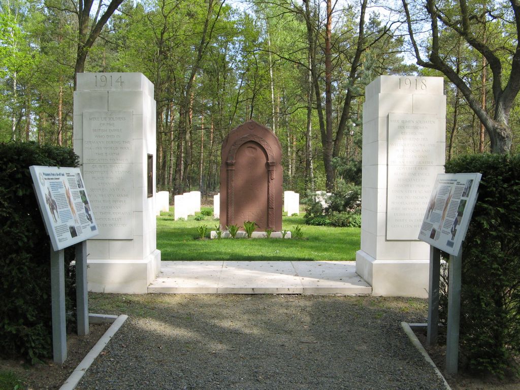
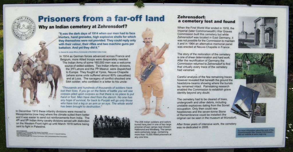
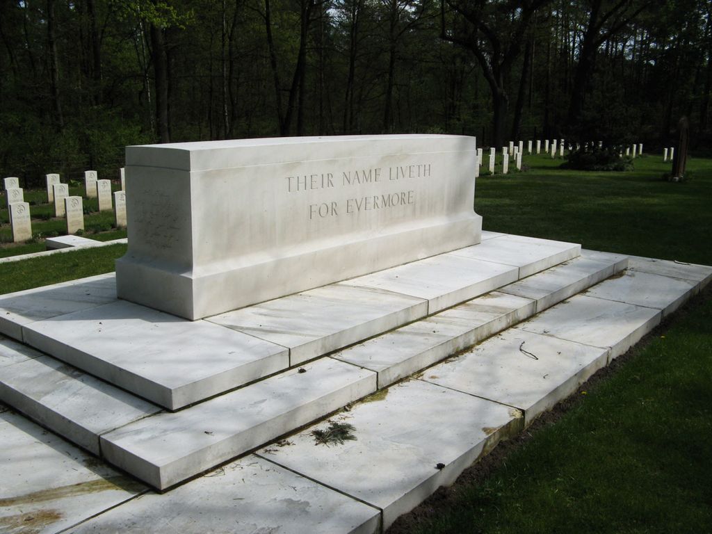
| Description | : | Zehrensdorf Indian Cemetery was established in 2005 by a joint effort of the Commonwealth War Graves Commission and the city of Zossen, Brandenburg, Germany. It contains the remains of 206 soldiers from India, who died at the prisoner of war camp in Zehrensdorf during World War I. The cemetery was reinstated following the reunification of Germany. The cemetery is in Zehrensdorf, a former village within the town of Wünsdorf, which belongs to the city of Zossen, in the German state of Brandenburg. Note: In order to read the information plaque depicted at the right, first left-click on the photo to open it, then... Read More |
frequently asked questions (FAQ):
-
Where is Zehrensdorf Indian Cemetery?
Zehrensdorf Indian Cemetery is located at Hauptallee Wünsdorf, Landkreis Teltow-Fläming ,Brandenburg , 15838Germany.
-
Zehrensdorf Indian Cemetery cemetery's updated grave count on graveviews.com?
0 memorials
-
Where are the coordinates of the Zehrensdorf Indian Cemetery?
Latitude: 52.1729900
Longitude: 13.5027500
Nearby Cemetories:
1. Friedhof Telz
Telz, Landkreis Dahme-Spreewald, Germany
Coordinate: 52.2461694, 13.4959545
2. Nächst Neuendorf
Zossen, Landkreis Teltow-Fläming, Germany
Coordinate: 52.2288977, 13.4169610
3. Lazarettfriedhof Saalow
Saalow, Landkreis Teltow-Fläming, Germany
Coordinate: 52.1911780, 13.3690690
4. Russian War Cemetery
Baruth, Landkreis Teltow-Fläming, Germany
Coordinate: 52.0666858, 13.5073874
5. Dorfkirche Paplitz
Paplitz, Landkreis Teltow-Fläming, Germany
Coordinate: 52.0520606, 13.4688510
6. Friedhof Zeesen
Zeesen, Landkreis Dahme-Spreewald, Germany
Coordinate: 52.2712916, 13.6300647
7. Friedhof Am Mühlenberg
Baruth, Landkreis Teltow-Fläming, Germany
Coordinate: 52.0445296, 13.5000393
8. Halbe Forest Cemetery
Halbe, Landkreis Dahme-Spreewald, Germany
Coordinate: 52.1029460, 13.6940900
9. Königs Wusterhausen
Königs Wusterhausen, Landkreis Dahme-Spreewald, Germany
Coordinate: 52.3000063, 13.6197819
10. Friedhof
Wietstock, Landkreis Teltow-Fläming, Germany
Coordinate: 52.2684914, 13.3193018
11. Friedhof Dahlewitz
Dahlewitz, Landkreis Teltow-Fläming, Germany
Coordinate: 52.3192110, 13.4369291
12. Friedhof Rotberg
Rotberg, Landkreis Dahme-Spreewald, Germany
Coordinate: 52.3407569, 13.5066658
13. Friedhof Märkisch Buchholz
Märkisch Buchholz, Landkreis Dahme-Spreewald, Germany
Coordinate: 52.1059096, 13.7601712
14. Dolgenbrodt Cemetery
Dolgenbrodt, Landkreis Dahme-Spreewald, Germany
Coordinate: 52.2429500, 13.7693100
15. Evangelischer Waldfriedhof Blankenfelde
Blankenfelde, Landkreis Teltow-Fläming, Germany
Coordinate: 52.3406365, 13.3993458
16. Friedhof Selchow
Schonefeld, Landkreis Dahme-Spreewald, Germany
Coordinate: 52.3571810, 13.4745870
17. Kirchhof Selchow
Schonefeld, Landkreis Dahme-Spreewald, Germany
Coordinate: 52.3582210, 13.4725110
18. Waldfriedhof Ludwigsfelde
Ludwigsfelde, Landkreis Teltow-Fläming, Germany
Coordinate: 52.2893256, 13.2592428
19. Kirchhof Waltersdorf
Schonefeld, Landkreis Dahme-Spreewald, Germany
Coordinate: 52.3619950, 13.5556590
20. Friedhof Waltersdorf
Schonefeld, Landkreis Dahme-Spreewald, Germany
Coordinate: 52.3626519, 13.5494779
21. Friedhof Zeuthen
Zeuthen, Landkreis Dahme-Spreewald, Germany
Coordinate: 52.3520629, 13.6297516
22. Kirchhof Wassmannsdorf
Schonefeld, Landkreis Dahme-Spreewald, Germany
Coordinate: 52.3710100, 13.4724170
23. Friedhof Wassmannsdorf
Schonefeld, Landkreis Dahme-Spreewald, Germany
Coordinate: 52.3715324, 13.4651613
24. Friedhof Rauchfangswerder
Schmockwitz, Treptow-Köpenick, Germany
Coordinate: 52.3584620, 13.6437320