
| Memorials | : | 0 |
| Location | : | Clay County, USA |
| Coordinate | : | 39.2928009, -97.1557999 |
frequently asked questions (FAQ):
-
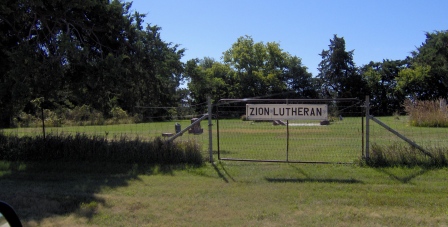
Where is Zion Lutheran Cemetery?
Zion Lutheran Cemetery is located at Clay County ,Kansas ,USA.
-
Zion Lutheran Cemetery cemetery's updated grave count on graveviews.com?
0 memorials
-
Where are the coordinates of the Zion Lutheran Cemetery?
Latitude: 39.2928009
Longitude: -97.1557999
Nearby Cemetories:
1. Pleasant Ridge Cemetery
Clay County, USA
Coordinate: 39.2789001, -97.1841965
2. Republican City Cemetery
Clay Center, Clay County, USA
Coordinate: 39.3431015, -97.1628036
3. Milo Chapman Gravesite
Broughton, Clay County, USA
Coordinate: 39.2888500, -97.0724400
4. Gilbert Cemetery
Clay County, USA
Coordinate: 39.2853012, -97.0625000
5. Uniondale Cemetery
Wakefield, Clay County, USA
Coordinate: 39.2382800, -97.0918400
6. Hebron Cemetery
Clay County, USA
Coordinate: 39.3213800, -97.2601400
7. Broughton Cemetery
Clay Center, Clay County, USA
Coordinate: 39.3306007, -97.0535965
8. Mizpah Cemetery
Clay County, USA
Coordinate: 39.2057800, -97.1238500
9. Wilson Cemetery
Clay County, USA
Coordinate: 39.3800011, -97.1896973
10. Saint John's Episcopal Cemetery
Clay County, USA
Coordinate: 39.2193985, -97.0744019
11. Table Mound Cemetery
Idana, Clay County, USA
Coordinate: 39.3141300, -97.2792300
12. Wesleyan Cemetery
Oak Hill, Clay County, USA
Coordinate: 39.2268982, -97.2572021
13. Clay County Poor Farm Cemetery
Clay Center, Clay County, USA
Coordinate: 39.3772700, -97.0727000
14. Idana Cemetery
Idana, Clay County, USA
Coordinate: 39.3574500, -97.2693300
15. Greenwood Cemetery
Clay Center, Clay County, USA
Coordinate: 39.4011002, -97.1275024
16. Saint Peter and Saint Pauls Catholic Cemetery
Clay Center, Clay County, USA
Coordinate: 39.4005450, -97.1236680
17. Pleasant Valley Cemetery
Oak Hill, Clay County, USA
Coordinate: 39.2468987, -97.2889023
18. Athelstane Cemetery
Athelstane Township, Clay County, USA
Coordinate: 39.1768990, -97.1753006
19. Gatesville Cemetery
Wakefield, Clay County, USA
Coordinate: 39.2721460, -97.0041380
20. Highland Cemetery
Wakefield, Clay County, USA
Coordinate: 39.2190247, -97.0133667
21. Shields Cemetery
Clay County, USA
Coordinate: 39.3208008, -97.3507996
22. Ebenezer Cemetery
Green, Clay County, USA
Coordinate: 39.3866997, -96.9974976
23. Timber Creek Cemetery
Wakefield, Clay County, USA
Coordinate: 39.2182999, -96.9805984
24. Madura Cemetery
Wakefield, Clay County, USA
Coordinate: 39.1842003, -97.0117035