
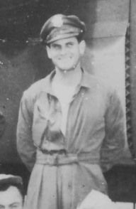
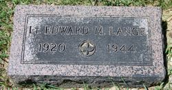

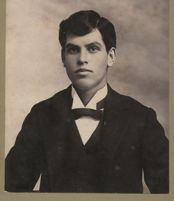
2LT Edward Marion Lange
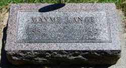
| Birth | : | 19 Mar 1920 Mitchell, Davison County, South Dakota, USA |
| Death | : | 29 Jan 1944 England |
| Burial | : | Riverside Cemetery, Spencer, Clay County, USA |
| Coordinate | : | 43.1441994, -95.1671982 |
| Plot | : | Block:3 Lot:59 Space:5 |
| Inscription | : | 2LT, 814 AAF BOMB SQ WORLD WAR II |
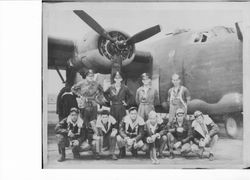
| Description | : | Bombardier 2nd/Lt. Edward M. Lange KIA Home: Los Angeles, CA Service # O-673203 Squadron: 814th Bomb Sq 482nd Bomb Gp Awards: Pilot 1/Lt James N. Taylor RTD Target: Frankfurt Germany Date Lost: 29-Jan-44 Serial Number: #42-7669 Aircraft Model B-24H Aircraft Letter: Aircraft Name: Location:one mile south of Station 124 (Tibenham) Cause: mid air collision crew of 11 8 KIA 3 RTD Briefings were held between 0330-0400 and at 0800 hours, (30) aircrews began take-offs. An unfortunate mishap occurred during form up, which began the aircrews' mission badly, when Lieutenant W. F. Usry's aircraft, #005... Read More |
frequently asked questions (FAQ):
-
Where is 2LT Edward Marion Lange's memorial?
2LT Edward Marion Lange's memorial is located at: Riverside Cemetery, Spencer, Clay County, USA.
-
When did 2LT Edward Marion Lange death?
2LT Edward Marion Lange death on 29 Jan 1944 in England
-
Where are the coordinates of the 2LT Edward Marion Lange's memorial?
Latitude: 43.1441994
Longitude: -95.1671982
Family Members:
Parent
Flowers:


Nearby Cemetories:
1. Riverside Cemetery
Spencer, Clay County, USA
Coordinate: 43.1441994, -95.1671982
2. Dewey Readmore Books Memorial
Spencer, Clay County, USA
Coordinate: 43.1403999, -95.1443024
3. North Lawn Cemetery
Spencer, Clay County, USA
Coordinate: 43.1600000, -95.1470000
4. Evergreen Cemetery
Clay County, USA
Coordinate: 43.2052994, -95.2086029
5. Fairview Cemetery
Clay County, USA
Coordinate: 43.1899986, -95.0800018
6. Swedish Lutheran Cemetery
Royal, Clay County, USA
Coordinate: 43.0683000, -95.2350000
7. Dickens Cemetery
Dickens, Clay County, USA
Coordinate: 43.1280000, -95.0155000
8. Rosehill Cemetery
Clay County, USA
Coordinate: 43.0368996, -95.0919037
9. Lone Tree Cemetery
Everly, Clay County, USA
Coordinate: 43.1411018, -95.3347015
10. Little Sioux Lutheran Cemetery
Milford, Dickinson County, USA
Coordinate: 43.2702065, -95.2109528
11. First Reformed Cemetery
Clay County, USA
Coordinate: 43.2399500, -95.2889000
12. Lincoln Cemetery
Rossie, Clay County, USA
Coordinate: 43.0111008, -95.2313995
13. Willow Creek Cemetery
Royal, Clay County, USA
Coordinate: 43.0214005, -95.2885971
14. Liberty Cemetery
Greenville, Clay County, USA
Coordinate: 42.9897003, -95.1417007
15. Clay Center Cemetery
Royal, Clay County, USA
Coordinate: 43.0410995, -95.3272018
16. Milford Cemetery
Milford, Dickinson County, USA
Coordinate: 43.3092003, -95.1481018
17. TriMello Cemetery
Royal, Clay County, USA
Coordinate: 43.0682983, -95.3728027
18. Logan Township Cemetery
Clay County, USA
Coordinate: 43.0489006, -94.9747009
19. Zion Methodist Cemetery
Clay County, USA
Coordinate: 42.9808006, -95.2497025
20. Calvary Cemetery
Milford, Dickinson County, USA
Coordinate: 43.3213997, -95.1688995
21. Fanny Fern Cemetery
Clay County, USA
Coordinate: 42.9530983, -95.1607971
22. Crown Hill Cemetery
Ruthven, Palo Alto County, USA
Coordinate: 43.1328011, -94.8878021
23. Calvary Cemetery
Ruthven, Palo Alto County, USA
Coordinate: 43.1314011, -94.8869019
24. Westport Cemetery
Dickinson County, USA
Coordinate: 43.3130989, -95.3289032