
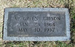
A. Green Gibson
| Birth | : | 28 Jan 1864 St. Francois County, Missouri, USA |
| Death | : | 10 May 1937 Elvins, St. Francois County, Missouri, USA |
| Burial | : | Rose Valley Cemetery, Downs, Osborne County, USA |
| Coordinate | : | 39.5456009, -98.5905991 |
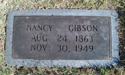
| Description | : | Husband of Nancy M. Sutterfield |
frequently asked questions (FAQ):
-
Where is A. Green Gibson's memorial?
A. Green Gibson's memorial is located at: Rose Valley Cemetery, Downs, Osborne County, USA.
-
When did A. Green Gibson death?
A. Green Gibson death on 10 May 1937 in Elvins, St. Francois County, Missouri, USA
-
Where are the coordinates of the A. Green Gibson's memorial?
Latitude: 39.5456009
Longitude: -98.5905991
Family Members:
Parent
Spouse
Siblings

Children


Nearby Cemetories:
1. Rose Valley Cemetery
Downs, Osborne County, USA
Coordinate: 39.5456009, -98.5905991
2. Rose Valley Cemetery
Gaylord, Smith County, USA
Coordinate: 39.5748997, -98.5799270
3. Farnsworth Family Burial Ground
Portis, Osborne County, USA
Coordinate: 39.5486100, -98.6486100
4. Downs Cemetery
Downs, Osborne County, USA
Coordinate: 39.5099983, -98.5528030
5. Oakdale Cemetery
Downs, Osborne County, USA
Coordinate: 39.5233002, -98.5152969
6. Bethany Center Cemetery
Portis, Osborne County, USA
Coordinate: 39.4947014, -98.6374969
7. Dispatch Cemetery
Dispatch, Smith County, USA
Coordinate: 39.5968510, -98.5055480
8. Twelvemile Cemetery
Gaylord, Smith County, USA
Coordinate: 39.6293800, -98.6361800
9. Reformed Cemetery
Jewell County, USA
Coordinate: 39.5957985, -98.4886017
10. Baker Cemetery
Osborne County, USA
Coordinate: 39.4522210, -98.6196690
11. Fairview Cemetery
Portis, Osborne County, USA
Coordinate: 39.5388985, -98.7193985
12. South Oak Creek Cemetery
Lebanon, Smith County, USA
Coordinate: 39.6439018, -98.5410995
13. Rooker Cemetery
Jewell County, USA
Coordinate: 39.5966988, -98.4661026
14. Corinth Cemetery
Corinth, Osborne County, USA
Coordinate: 39.4439011, -98.5269012
15. Garrett Cemetery
Harlan, Smith County, USA
Coordinate: 39.5873500, -98.7290900
16. Saint Aloysius Cemetery
Osborne, Osborne County, USA
Coordinate: 39.4536018, -98.6903000
17. Saints Peter and Paul Cemetery
Cawker City, Mitchell County, USA
Coordinate: 39.5248130, -98.4282290
18. Prairie Grove Cemetery
Cawker City, Mitchell County, USA
Coordinate: 39.5243988, -98.4257965
19. Hammond Cemetery
Harlan, Smith County, USA
Coordinate: 39.5896500, -98.7479700
20. Osborne Cemetery
Osborne, Osborne County, USA
Coordinate: 39.4514008, -98.7138977
21. Bell Cemetery
Smith Center, Smith County, USA
Coordinate: 39.6477700, -98.7102200
22. North Oak Creek Cemetery
Lebanon, Smith County, USA
Coordinate: 39.6906100, -98.5565800
23. Old Harlan Cemetery
Harlan, Smith County, USA
Coordinate: 39.6153520, -98.7632390
24. Crystal Plains Cemetery
Smith Center, Smith County, USA
Coordinate: 39.6909714, -98.6730270