
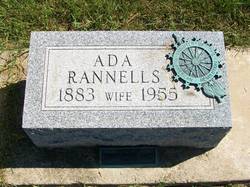
Ada L Rannells Deniston
| Birth | : | 25 Feb 1883 |
| Death | : | 8 Apr 1955 |
| Burial | : | Memorial Park Cemetery, Albany, Albany City, Australia |
| Coordinate | : | -35.0172430, 117.8886040 |
| Plot | : | Section 5, Row 5 |
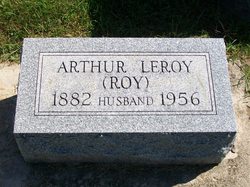
| Description | : | Published in The Rochester News-Sentinel Saturday, April 9, 1955 Ada R. Deniston Mrs. A. L. DENISTON, 72, of 1310 Main street, died at 10:45 p.m. Friday at Woodlawn hospital from a heart attack suffered at her home at four o'clock Friday afternoon. She had been in failing health for the past 10 years and was admitted to the hospital at 5:30 p.m. Friday following the heart seuzure. Ada R. DENISTON, resident of Rochester her entire life, was born Feb. 25, 1883, to [Lycurgus] and Dora [E.] ROBBINS RANNELLS. On June 24, 1903, in Rochester she was married to [Arthur Leroy "Roy"] DENISTON. She was a... Read More |
frequently asked questions (FAQ):
-
Where is Ada L Rannells Deniston's memorial?
Ada L Rannells Deniston's memorial is located at: Memorial Park Cemetery, Albany, Albany City, Australia.
-
When did Ada L Rannells Deniston death?
Ada L Rannells Deniston death on 8 Apr 1955 in
-
Where are the coordinates of the Ada L Rannells Deniston's memorial?
Latitude: -35.0172430
Longitude: 117.8886040
Family Members:
Parent
Spouse
Siblings

Children
Flowers:


Nearby Cemetories:
1. Memorial Park Cemetery
Albany, Albany City, Australia
Coordinate: -35.0172430, 117.8886040
2. Albany Burial Ground (Lot S112)
Albany City, Australia
Coordinate: -35.0237650, 117.8822610
3. Albany Burial Ground (Lot S115)
Albany City, Australia
Coordinate: -35.0247100, 117.8825210
4. Memorial Park Burial Site
Albany, Albany City, Australia
Coordinate: -35.0157600, 117.9024200
5. Allambie Park Cemetery
Albany, Albany City, Australia
Coordinate: -34.9809910, 117.9200340
6. St. Werburgh's Chapel & Cemetery
Mount Barker, Plantagenet Shire, Australia
Coordinate: -34.6853069, 117.5996387
7. Mount Barker Cemetery East
Mount Barker, Plantagenet Shire, Australia
Coordinate: -34.6437373, 117.6709039
8. Mount Barker Cemetery West
Mount Barker, Plantagenet Shire, Australia
Coordinate: -34.6437679, 117.6692459
9. Denmark Public Cemetery
Denmark, Denmark Shire, Australia
Coordinate: -34.9542900, 117.3764500
10. Tenterden General Cemetery
Tenterden, Cranbrook Shire, Australia
Coordinate: -34.3652251, 117.5709322
11. Tenterden War Memorial
Tenterden, Cranbrook Shire, Australia
Coordinate: -34.3652200, 117.5584600
12. Wansbrough Burial
Wansbrough, Broomehill-Tambellup Shire, Australia
Coordinate: -34.1425430, 117.6733960
13. Walpole Cemetery
Walpole, Manjimup Shire, Australia
Coordinate: -34.9787030, 116.7456710
14. Bonshaw Burial Ground
Cranbrook Shire, Australia
Coordinate: -34.1871390, 117.3203610
15. Borden Cemetery
Borden, Gnowangerup Shire, Australia
Coordinate: -34.0727430, 118.2646100
16. Tambellup Cemetery
Tambellup, Broomehill-Tambellup Shire, Australia
Coordinate: -34.0353790, 117.6330330
17. Gnowangerup Cemetery
Gnowangerup, Gnowangerup Shire, Australia
Coordinate: -33.9461540, 118.0135490
18. Pindellup St. Peters Church of England
Tambellup, Broomehill-Tambellup Shire, Australia
Coordinate: -33.9755683, 117.4940883
19. Broomehill Cemetery
Broomehill, Broomehill-Tambellup Shire, Australia
Coordinate: -33.8477960, 117.6227830
20. Eticup Cemetery
Broomehill, Broomehill-Tambellup Shire, Australia
Coordinate: -33.8328280, 117.5639560
21. Kojonup Cemetery
Kojonup, Kojonup Shire, Australia
Coordinate: -33.8248400, 117.1526770
22. Jerramungup Cemetery
Gnowangerup, Gnowangerup Shire, Australia
Coordinate: -33.9471830, 118.8849460
23. Chowerup Cemetery
Chowerup, Boyup Brook Shire, Australia
Coordinate: -34.0858380, 116.7028610
24. Bremer Bay Cemetery
Bremer Bay, Jerramungup Shire, Australia
Coordinate: -34.4120310, 119.3795230