
| Birth | : | 18 May 1888 Spartanburg County, South Carolina, USA |
| Death | : | 9 Jan 1979 Bonham, Union County, South Carolina, USA |
| Burial | : | Capay Cemetery, Esparto, Yolo County, USA |
| Coordinate | : | 38.6944008, -122.0447006 |
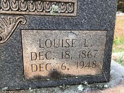
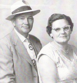
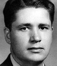
| Description | : | Grandpa "Sugar Bill" was a son of Louise Lawson Varner and stepson of Henry Varner. He married (1) Mary Lillian Steen --(2) Julie Varner --(3) Lily McAbee Children of Clarence and Mary: Ed - Jim - Bill - Howard - Verona (Beheler)and Fred |
frequently asked questions (FAQ):
-
Where is Adolphus Clarence “Sugar Bill” Lawson's memorial?
Adolphus Clarence “Sugar Bill” Lawson's memorial is located at: Capay Cemetery, Esparto, Yolo County, USA.
-
When did Adolphus Clarence “Sugar Bill” Lawson death?
Adolphus Clarence “Sugar Bill” Lawson death on 9 Jan 1979 in Bonham, Union County, South Carolina, USA
-
Where are the coordinates of the Adolphus Clarence “Sugar Bill” Lawson's memorial?
Latitude: 38.6944008
Longitude: -122.0447006
Family Members:
Parent
Spouse

Siblings
Children
Flowers:


Nearby Cemetories:
1. Capay Cemetery
Esparto, Yolo County, USA
Coordinate: 38.6944008, -122.0447006
2. Cottonwood Cemetery
Winters, Yolo County, USA
Coordinate: 38.6500015, -121.9677963
3. Corbin Cemetery
Esparto, Yolo County, USA
Coordinate: 38.6240710, -122.0105040
4. Gordon Family Cemetery
Esparto, Yolo County, USA
Coordinate: 38.6966060, -121.9151540
5. Monument Hill Memorial Park
Woodland, Yolo County, USA
Coordinate: 38.6781020, -121.8566400
6. Logan Cemetery
Guinda, Yolo County, USA
Coordinate: 38.8401670, -122.1613410
7. Winters Cemetery
Winters, Yolo County, USA
Coordinate: 38.5256004, -121.9777985
8. Guinda Cemetery
Guinda, Yolo County, USA
Coordinate: 38.8189290, -122.2103300
9. Cacheville Cemetery
Yolo, Yolo County, USA
Coordinate: 38.7378300, -121.8090200
10. Marys Cemetery
Yolo, Yolo County, USA
Coordinate: 38.7635994, -121.8032990
11. Woodland Cemetery
Woodland, Yolo County, USA
Coordinate: 38.6711006, -121.7846985
12. Saint Joseph Cemetery
Woodland, Yolo County, USA
Coordinate: 38.6694400, -121.7842120
13. Monticello Cemetery
Spanish Flat, Napa County, USA
Coordinate: 38.5368996, -122.2264023
14. Wragg Canyon Cemetery
Napa County, USA
Coordinate: 38.4680220, -122.1562050
15. Knights Landing Cemetery
Knights Landing, Yolo County, USA
Coordinate: 38.7904530, -121.7284190
16. Episcopal Church of Saint Martin Columbarium
Davis, Yolo County, USA
Coordinate: 38.5488870, -121.7611850
17. Johns Cemetery
Colusa County, USA
Coordinate: 38.9571991, -121.9689026
18. Davis Cemetery
Davis, Yolo County, USA
Coordinate: 38.5550003, -121.7260971
19. Valley Cemetery
Pope Valley, Napa County, USA
Coordinate: 38.6470570, -122.4255870
20. Sacramento Valley National Cemetery
Dixon, Solano County, USA
Coordinate: 38.4167800, -121.8754000
21. Dixon Cemetery
Dixon, Solano County, USA
Coordinate: 38.4354553, -121.8227005
22. Las Posadas Pioneer Cemetery
Napa County, USA
Coordinate: 38.5581017, -122.4044037
23. College City Cemetery
College City, Colusa County, USA
Coordinate: 39.0089130, -122.0065960
24. Duvall Cemetery
Napa County, USA
Coordinate: 38.6508970, -122.4627180