

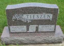
Aganetha “Nettie” Ewert Tieszen
| Birth | : | 29 Nov 1882 South Dakota, USA |
| Death | : | 1976 Turner County, South Dakota, USA |
| Burial | : | Tieszen Cemetery, Marion, Turner County, USA |
| Coordinate | : | 43.4219017, -97.3388977 |
frequently asked questions (FAQ):
-
Where is Aganetha “Nettie” Ewert Tieszen's memorial?
Aganetha “Nettie” Ewert Tieszen's memorial is located at: Tieszen Cemetery, Marion, Turner County, USA.
-
When did Aganetha “Nettie” Ewert Tieszen death?
Aganetha “Nettie” Ewert Tieszen death on 1976 in Turner County, South Dakota, USA
-
Where are the coordinates of the Aganetha “Nettie” Ewert Tieszen's memorial?
Latitude: 43.4219017
Longitude: -97.3388977
Family Members:
Parent

Spouse
Siblings
Children
Flowers:


Nearby Cemetories:
1. Tieszen Cemetery
Marion, Turner County, USA
Coordinate: 43.4219017, -97.3388977
2. Dick Cemetery
Turner County, USA
Coordinate: 43.4528008, -97.3319016
3. Mennonite Cemetery
Dolton, Turner County, USA
Coordinate: 43.4472008, -97.3788986
4. Buller-Ensz Cemetery
Turner County, USA
Coordinate: 43.4186000, -97.2828500
5. West Vermillion Cemetery
Marion, Turner County, USA
Coordinate: 43.4706001, -97.3189011
6. First Church of God Cemetery
Marion, Turner County, USA
Coordinate: 43.4447000, -97.2727000
7. Anna Koerner Burial Site
Hutchinson County, USA
Coordinate: 43.4290258, -97.4196065
8. Saint Marys Catholic Cemetery
Marion, Turner County, USA
Coordinate: 43.4371986, -97.2596970
9. Greenwood Cemetery
Marion, Turner County, USA
Coordinate: 43.4150009, -97.2493973
10. Tschetter Cemetery
Freeman, Hutchinson County, USA
Coordinate: 43.3866997, -97.4197006
11. Our Lady of Lourdes Catholic Cemetery
Dolton, Turner County, USA
Coordinate: 43.4871320, -97.3732960
12. Salem Zion Mennonite Cemetery
Turner County, USA
Coordinate: 43.3507996, -97.3296967
13. Adrian Cemetery
Freeman, Hutchinson County, USA
Coordinate: 43.4730320, -97.4196550
14. Hutterthal Mennonite Church Cemetery
Freeman, Hutchinson County, USA
Coordinate: 43.4041400, -97.4605000
15. Rose Hill Cemetery
McCook County, USA
Coordinate: 43.5119019, -97.3478012
16. Salem Mennonite Church Cemetery
Turner County, USA
Coordinate: 43.3141890, -97.3364110
17. Monroe Reformed Church Cemetery
McCook County, USA
Coordinate: 43.5004100, -97.2358170
18. Turkey Valley Cemetery
Parker, Turner County, USA
Coordinate: 43.3280600, -97.2505500
19. Riverside Cemetery
Canistota, McCook County, USA
Coordinate: 43.5360985, -97.3283005
20. Freeman Cemetery
Freeman, Hutchinson County, USA
Coordinate: 43.3432999, -97.4589005
21. Kleinkassel Cemetery
Hutchinson County, USA
Coordinate: 43.4369011, -97.4997025
22. Spring Valley Baptist Cemetery
Spring Valley Township, McCook County, USA
Coordinate: 43.5325920, -97.2290730
23. Saint Christina Cemetery
Parker, Turner County, USA
Coordinate: 43.3903008, -97.1502991
24. West Side Cemetery
Turner County, USA
Coordinate: 43.2849998, -97.2891998