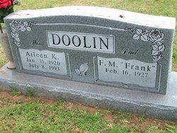
Aileen K Kendrick Doolin
| Birth | : | 31 Jan 1920 |
| Death | : | 8 Jul 1993 |
| Burial | : | Philips Park Cemetery, Miles Platting, Metropolitan Borough of Manchester, England |
| Coordinate | : | 53.4898020, -2.2007400 |
| Plot | : | section 2 |
| Inscription | : | Mom Dad |
frequently asked questions (FAQ):
-
Where is Aileen K Kendrick Doolin's memorial?
Aileen K Kendrick Doolin's memorial is located at: Philips Park Cemetery, Miles Platting, Metropolitan Borough of Manchester, England.
-
When did Aileen K Kendrick Doolin death?
Aileen K Kendrick Doolin death on 8 Jul 1993 in
-
Where are the coordinates of the Aileen K Kendrick Doolin's memorial?
Latitude: 53.4898020
Longitude: -2.2007400
Family Members:
Parent
Siblings
Children
Flowers:
Nearby Cemetories:
1. Philips Park Cemetery
Miles Platting, Metropolitan Borough of Manchester, England
Coordinate: 53.4898020, -2.2007400
2. St Cross Churchyard
Clayton, Metropolitan Borough of Manchester, England
Coordinate: 53.4832190, -2.1823530
3. All Saints Churchyard
Newton Heath, Metropolitan Borough of Manchester, England
Coordinate: 53.5002260, -2.1777970
4. Manchester General Cemetery
Manchester, Metropolitan Borough of Manchester, England
Coordinate: 53.5062710, -2.2179570
5. St Thomas Churchyard
Ardwick, Metropolitan Borough of Manchester, England
Coordinate: 53.4720000, -2.2248900
6. Christchurch Harpurhey Churchyard
Harpurhey, Metropolitan Borough of Manchester, England
Coordinate: 53.5115100, -2.2134800
7. St Chad's Churchyard
Cheetham Hill, Metropolitan Borough of Manchester, England
Coordinate: 53.4922100, -2.2400500
8. All Saints Churchyard
Chorlton-on-Medlock, Metropolitan Borough of Manchester, England
Coordinate: 53.4666670, -2.2166670
9. St Luke's Churchyard
Cheetham Hill, Metropolitan Borough of Manchester, England
Coordinate: 53.5041660, -2.2354680
10. St. Joseph's Roman Catholic Churchyard
Moston, Metropolitan Borough of Manchester, England
Coordinate: 53.5149270, -2.1877070
11. Manchester Cathedral
Manchester, Metropolitan Borough of Manchester, England
Coordinate: 53.4852760, -2.2446010
12. Strangeways Prison Cemetery (Defunct)
Manchester, Metropolitan Borough of Manchester, England
Coordinate: 53.4925000, -2.2463890
13. Crumpsall Jewish Cemetery
Crumpsall, Metropolitan Borough of Manchester, England
Coordinate: 53.5124250, -2.2280270
14. Saint Ann's Churchyard
Manchester, Metropolitan Borough of Manchester, England
Coordinate: 53.4817542, -2.2457527
15. Droylsden Cemetery
Droylsden, Metropolitan Borough of Tameside, England
Coordinate: 53.4849400, -2.1529696
16. St Mary's Roman Catholic Church
Manchester, Metropolitan Borough of Manchester, England
Coordinate: 53.4800820, -2.2463900
17. St Savior Churchyard
Manchester, Metropolitan Borough of Manchester, England
Coordinate: 53.4654560, -2.2269220
18. Saint Peters Street
Manchester, Metropolitan Borough of Manchester, England
Coordinate: 53.4777660, -2.2453600
19. St. Mary's Churchyard (Defunct)
Manchester, Metropolitan Borough of Manchester, England
Coordinate: 53.4825726, -2.2483873
20. Christ Church
Salford, Metropolitan Borough of Salford, England
Coordinate: 53.4864284, -2.2497653
21. St Lukes Churchyard
Manchester, Metropolitan Borough of Manchester, England
Coordinate: 53.4704000, -2.2386500
22. Failsworth Cemetery
Failsworth, Metropolitan Borough of Oldham, England
Coordinate: 53.5048760, -2.1537550
23. Saint Mary's Churchyard
Moston, Metropolitan Borough of Manchester, England
Coordinate: 53.5181740, -2.1763410
24. Failsworth Jewish Cemetery
Failsworth, Metropolitan Borough of Oldham, England
Coordinate: 53.5050270, -2.1534220


