
| Memorials | : | 1504 |
| Location | : | Salford, Metropolitan Borough of Salford, England |
| Coordinate | : | 53.4864284, -2.2497653 |
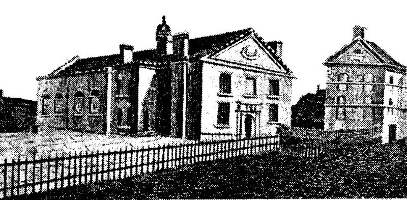
| Description | : | Established in 1800 by Reverend William Cowherd as a branch of the Swedenborgian church, Christ Church grew to become one of Salford's key religious and socio-cultural institutions, functioning not only as a place of worship but provider of welfare and education. The church was completed in 1809 and remained in use until the 1860s. The site was used as a burial ground from 1800 catering for both its congregation and the poor, to whom it offered free burials. Two burial grounds are supposed to have existed: a graveyard for marked burials in the west of the site,... Read More |
frequently asked questions (FAQ):
-
Where is Christ Church?
Christ Church is located at 2-8 King Street Salford, Metropolitan Borough of Salford ,Greater Manchester , M3 7BNEngland.
-
Christ Church cemetery's updated grave count on graveviews.com?
44 memorials
-
Where are the coordinates of the Christ Church?
Latitude: 53.4864284
Longitude: -2.2497653


Nearby Cemetories:
1. Manchester Cathedral
Manchester, Metropolitan Borough of Manchester, England
Coordinate: 53.4852760, -2.2446010
2. St. Mary's Churchyard (Defunct)
Manchester, Metropolitan Borough of Manchester, England
Coordinate: 53.4825726, -2.2483873
3. Saint Ann's Churchyard
Manchester, Metropolitan Borough of Manchester, England
Coordinate: 53.4817542, -2.2457527
4. New Jerusalem Temple Cemetery
Salford, Metropolitan Borough of Salford, England
Coordinate: 53.4827720, -2.2571250
5. Irwell Street Wesleyan Chapel Cemetery
Salford, Metropolitan Borough of Salford, England
Coordinate: 53.4829750, -2.2587540
6. Strangeways Prison Cemetery (Defunct)
Manchester, Metropolitan Borough of Manchester, England
Coordinate: 53.4925000, -2.2463890
7. St Mary's Roman Catholic Church
Manchester, Metropolitan Borough of Manchester, England
Coordinate: 53.4800820, -2.2463900
8. St Chad's Churchyard
Cheetham Hill, Metropolitan Borough of Manchester, England
Coordinate: 53.4922100, -2.2400500
9. St John's Churchyard
Manchester, Metropolitan Borough of Manchester, England
Coordinate: 53.4780043, -2.2526487
10. Saint Peters Street
Manchester, Metropolitan Borough of Manchester, England
Coordinate: 53.4777660, -2.2453600
11. Great Bridgewater St. Wesleyan Methodist Churchyard
Manchester, Metropolitan Borough of Manchester, England
Coordinate: 53.4757580, -2.2500770
12. St George Churchyard
Hulme, Metropolitan Borough of Manchester, England
Coordinate: 53.4721400, -2.2593000
13. St Lukes Churchyard
Manchester, Metropolitan Borough of Manchester, England
Coordinate: 53.4704000, -2.2386500
14. St Luke's Churchyard
Cheetham Hill, Metropolitan Borough of Manchester, England
Coordinate: 53.5041660, -2.2354680
15. St Thomas Churchyard
Ardwick, Metropolitan Borough of Manchester, England
Coordinate: 53.4720000, -2.2248900
16. St. Thomas' Churchyard
Salford, Metropolitan Borough of Salford, England
Coordinate: 53.4921430, -2.2856130
17. St Savior Churchyard
Manchester, Metropolitan Borough of Manchester, England
Coordinate: 53.4654560, -2.2269220
18. St. Marks' Churchyard
Cheetham Hill, Metropolitan Borough of Manchester, England
Coordinate: 53.5113780, -2.2462660
19. Manchester General Cemetery
Manchester, Metropolitan Borough of Manchester, England
Coordinate: 53.5062710, -2.2179570
20. All Saints Churchyard
Chorlton-on-Medlock, Metropolitan Borough of Manchester, England
Coordinate: 53.4666670, -2.2166670
21. Wesleyan Methodist Cemetery
Crumpsall, Metropolitan Borough of Manchester, England
Coordinate: 53.5142870, -2.2447610
22. Christ Church Churchyard
Chorlton-on-Medlock, Metropolitan Borough of Manchester, England
Coordinate: 53.4592000, -2.2362000
23. Crumpsall Jewish Cemetery
Crumpsall, Metropolitan Borough of Manchester, England
Coordinate: 53.5124250, -2.2280270
24. Philips Park Cemetery
Miles Platting, Metropolitan Borough of Manchester, England
Coordinate: 53.4898020, -2.2007400