

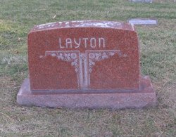
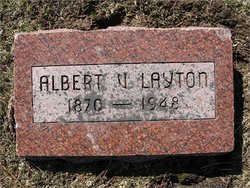
Albert V Layton
| Birth | : | Jun 1871 Illinois, USA |
| Death | : | 1948 Sarpy County, Nebraska, USA |
| Burial | : | Ascension Cemetery, Bel Aire, Sedgwick County, USA |
| Coordinate | : | 37.7675018, -97.2533035 |
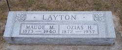
| Description | : | Marriage to Mary Mahala Thompson on June 17, 1903 at the age of 32. Father of Harry H (1904-1978). |
frequently asked questions (FAQ):
-
Where is Albert V Layton's memorial?
Albert V Layton's memorial is located at: Ascension Cemetery, Bel Aire, Sedgwick County, USA.
-
When did Albert V Layton death?
Albert V Layton death on 1948 in Sarpy County, Nebraska, USA
-
Where are the coordinates of the Albert V Layton's memorial?
Latitude: 37.7675018
Longitude: -97.2533035
Family Members:
Parent

Spouse
Siblings
Children
Flowers:


Nearby Cemetories:
1. Ascension Cemetery
Bel Aire, Sedgwick County, USA
Coordinate: 37.7675018, -97.2533035
2. Lutheran Cemetery
Wichita, Sedgwick County, USA
Coordinate: 37.7664986, -97.2443008
3. Greenwich Cemetery
Wichita, Sedgwick County, USA
Coordinate: 37.7518997, -97.2266998
4. Kechi Township Cemetery
Park City, Sedgwick County, USA
Coordinate: 37.8022003, -97.3000031
5. Wichita Hebrew Cemetery
Wichita, Sedgwick County, USA
Coordinate: 37.7201004, -97.2798004
6. Wichita Park Cemetery and Mausoleum
Wichita, Sedgwick County, USA
Coordinate: 37.7277985, -97.2960968
7. Fairview Cemetery
Kechi, Sedgwick County, USA
Coordinate: 37.8194008, -97.2450027
8. Old Mission Cemetery
Wichita, Sedgwick County, USA
Coordinate: 37.7243996, -97.2964020
9. Old Mission Mausoleum
Wichita, Sedgwick County, USA
Coordinate: 37.7242600, -97.2967400
10. Mission Chapel Mausoleum
Wichita, Sedgwick County, USA
Coordinate: 37.7231200, -97.2955100
11. White Chapel Memorial Gardens
Wichita, Sedgwick County, USA
Coordinate: 37.7162018, -97.2806015
12. Kensington Gardens Cemetery
Wichita, Sedgwick County, USA
Coordinate: 37.7230988, -97.2040024
13. Saint Stephen's Episcopal Church Columbarium
Wichita, Sedgwick County, USA
Coordinate: 37.6999272, -97.2505590
14. Maple Grove Cemetery
Wichita, Sedgwick County, USA
Coordinate: 37.7036018, -97.2949982
15. Lakeview Cemetery & Mausoleum
Wichita, Sedgwick County, USA
Coordinate: 37.7086601, -97.1978989
16. Highland Cemetery
Wichita, Sedgwick County, USA
Coordinate: 37.7028008, -97.3007965
17. Pierpont Cemetery
Sedgwick County, USA
Coordinate: 37.7011400, -97.2077500
18. Temple Emanuel Cemetery
Wichita, Sedgwick County, USA
Coordinate: 37.7014000, -97.3008000
19. Lorraine Avenue Mennonite Church Cemetery
Valley Center, Sedgwick County, USA
Coordinate: 37.8408012, -97.1977997
20. East Heights United Methodist Memorial Garden
Wichita, Sedgwick County, USA
Coordinate: 37.6854100, -97.2845500
21. Saint James Episcopal Church Columbarium
Wichita, Sedgwick County, USA
Coordinate: 37.6865600, -97.2930000
22. Maple Grove Cemetery
Valley Center, Sedgwick County, USA
Coordinate: 37.8401985, -97.3259964
23. Deem Family Cemetery
Benton, Butler County, USA
Coordinate: 37.7491951, -97.1350937
24. Calvary Cemetery
Wichita, Sedgwick County, USA
Coordinate: 37.6781006, -97.2949982