
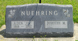
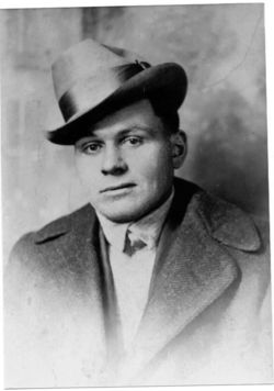
Alden Edward Busacker “Jim” Nuehring
| Birth | : | 16 May 1916 Clayton, Clayton County, Iowa, USA |
| Death | : | 29 Jan 2002 La Crescent, Houston County, Minnesota, USA |
| Burial | : | Victor Sunnyside Cemetery, Victor, Teller County, USA |
| Coordinate | : | 38.7063890, -105.1543610 |
| Description | : | ALDEN "Jim" EDWARD BUSACKER NUEHRING Funeral services for "Jim" Nuehring were held Saturday, February 2, 2002, at 11:00 A.M. in St. Paul Lutheran Church at Postville, Iowa. The Reverend James Allison officiated. Ramona Everman was the organist and Ronald Meyer was the soloist. The Casket Bearers were: Lee Thoma, Eugene Nuehring, David Nuehring, Michael DeMarr, Leon Casten, Gary Landsgard, Karl Casten, and honorary Casket Bearers were: Jim and Marie Farmer, Jack Messler, Mervin Larson, Cliff J. and Ida Olson, Gerald and Verda Palas, Doug and Virginia Behrens. The Schutte Funeral and Cremation Service of Postville was in charge of arrangements.... Read More |
frequently asked questions (FAQ):
-
Where is Alden Edward Busacker “Jim” Nuehring's memorial?
Alden Edward Busacker “Jim” Nuehring's memorial is located at: Victor Sunnyside Cemetery, Victor, Teller County, USA.
-
When did Alden Edward Busacker “Jim” Nuehring death?
Alden Edward Busacker “Jim” Nuehring death on 29 Jan 2002 in La Crescent, Houston County, Minnesota, USA
-
Where are the coordinates of the Alden Edward Busacker “Jim” Nuehring's memorial?
Latitude: 38.7063890
Longitude: -105.1543610
Family Members:
Parent
Spouse
Siblings
Flowers:


Nearby Cemetories:
1. Victor Sunnyside Cemetery
Victor, Teller County, USA
Coordinate: 38.7063890, -105.1543610
2. Saint Andrews Episcopal Church Columbarium
Cripple Creek, Teller County, USA
Coordinate: 38.7480000, -105.1746000
3. Mount Pisgah Cemetery
Cripple Creek, Teller County, USA
Coordinate: 38.7486000, -105.1943970
4. Garden Park Cemetery
Canon City, Fremont County, USA
Coordinate: 38.5685000, -105.2264000
5. Carl Lotave Memorial
Colorado Springs, El Paso County, USA
Coordinate: 38.8409190, -105.0431470
6. Fourmile Cemetery
Florissant, Teller County, USA
Coordinate: 38.8471985, -105.2786026
7. Upper Beaver Creek Cemetery
Coal Creek, Fremont County, USA
Coordinate: 38.5443993, -105.0306015
8. Inspiration Point Graves
El Paso County, USA
Coordinate: 38.7817930, -104.8793080
9. Jackson Cemetery
Colorado Springs, El Paso County, USA
Coordinate: 38.7813988, -104.8780975
10. Henry Harkins Gravesite
El Paso County, USA
Coordinate: 38.6711000, -104.8583500
11. Will Rogers Shrine of the Sun Chapel Crypt
Colorado Springs, El Paso County, USA
Coordinate: 38.7717000, -104.8631000
12. Burnett Cemetery
Fremont County, USA
Coordinate: 38.4733000, -105.0898000
13. Eskilsonn Cemetery
Canon City, Fremont County, USA
Coordinate: 38.5954000, -105.4269000
14. Divide Cemetery
Divide, Teller County, USA
Coordinate: 38.9496994, -105.1564026
15. Florissant Cemetery
Florissant, Teller County, USA
Coordinate: 38.9324989, -105.2724991
16. Crystal Valley Cemetery
Manitou Springs, El Paso County, USA
Coordinate: 38.8527832, -104.9033051
17. Skyline Drive West Cemetery
Canon City, Fremont County, USA
Coordinate: 38.4726000, -105.2578000
18. Mountain Wilderness Memorial Park
Woodland Park, Teller County, USA
Coordinate: 38.9458046, -105.0578842
19. Star Ranch Burial Site
Colorado Springs, El Paso County, USA
Coordinate: 38.7559720, -104.8377780
20. Pet Rest Memorial Park
Colorado Springs, El Paso County, USA
Coordinate: 38.7013200, -104.8292490
21. Holy Cross Abbey Cemetery
Fremont County, USA
Coordinate: 38.4520000, -105.2013000
22. Fairview Cemetery
Colorado Springs, El Paso County, USA
Coordinate: 38.8410988, -104.8719025
23. Chapel of Our Saviour Columbarium
Colorado Springs, El Paso County, USA
Coordinate: 38.7961000, -104.8435600
24. Paupers Cemetery
Colorado Springs, El Paso County, USA
Coordinate: 38.8281500, -104.8594000