

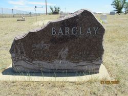
Alexander William “Sandy” Barclay
| Birth | : | 10 Aug 1941 Jordan, Garfield County, Montana, USA |
| Death | : | 28 Jun 2016 Billings, Yellowstone County, Montana, USA |
| Burial | : | Pioneer Cemetery, Jordan, Garfield County, USA |
| Coordinate | : | 47.3244019, -106.9238968 |
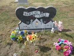
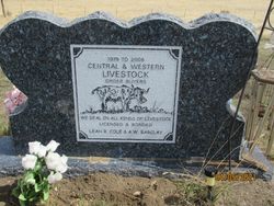
| Inscription | : | Front: BACLAY COLE MARRIED AUG. 9 1980 Back: 1979 TO 2008 CENTRAL & WESTERN LIVESTOCK ORDER BUYERS LEAH R. COLE & A.W. BARCLAY |
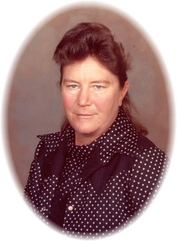
| Description | : | Alexander William "Sandy" Barclay, age 74, of Jordan passed away on Tuesday, June 28, 2016 at St. Vincent Hospital in Billings, Montana surrounded by his family. Sandy was born on August 10, 1941 in Jordan, Montana, the son of Alex S. and Doris Jeanette McKnight. He attended Flat Creek School through the 8th grade. After the 8th grade he worked for Boyd Isaac, Francis Henning, Jappy Likes, Edgar Loomis and Keith Kibler. He hauled hay to Washington for Keith, where he met his first wife Jean Austin and her daughter Judy Kay. Sandy and Jean... Read More |
frequently asked questions (FAQ):
-
Where is Alexander William “Sandy” Barclay's memorial?
Alexander William “Sandy” Barclay's memorial is located at: Pioneer Cemetery, Jordan, Garfield County, USA.
-
When did Alexander William “Sandy” Barclay death?
Alexander William “Sandy” Barclay death on 28 Jun 2016 in Billings, Yellowstone County, Montana, USA
-
Where are the coordinates of the Alexander William “Sandy” Barclay's memorial?
Latitude: 47.3244019
Longitude: -106.9238968
Family Members:
Parent

Spouse
Siblings
Flowers:


Nearby Cemetories:
1. Pioneer Cemetery
Jordan, Garfield County, USA
Coordinate: 47.3244019, -106.9238968
2. Greenridge Cemetery
Jordan, Garfield County, USA
Coordinate: 47.3389015, -106.8946991
3. Hinther Cemetery
Garfield County, USA
Coordinate: 47.2685000, -107.0218000
4. Butte Creek Cemetery
Garfield County, USA
Coordinate: 47.4777985, -107.2341995
5. Steve Forks Cemetery
Garfield County, USA
Coordinate: 47.2627983, -107.3321991
6. Cohagen Cemetery
Cohagen, Garfield County, USA
Coordinate: 47.0772018, -106.6232986
7. Darnall-Armbruster-Hubbard Family Cemetery
Garfield County, USA
Coordinate: 47.6407000, -107.0645200
8. Neudorfer Cemetery
Jordan, Garfield County, USA
Coordinate: 47.2095000, -106.2772000
9. Hearts at Peace Cemetery
Brusett, Garfield County, USA
Coordinate: 47.5441900, -107.5399200
10. Wolf Cemetery
Garfield County, USA
Coordinate: 47.1528015, -107.5924988
11. Vanstel Cemetery
Rosebud County, USA
Coordinate: 46.7872009, -106.8942032
12. Haglunds Ritchie Cemetery
McCone County, USA
Coordinate: 47.3246994, -106.0639038
13. Biebers Cemetery
McCone County, USA
Coordinate: 47.2386100, -106.0348800
14. Biebers Cemetery
McCone County, USA
Coordinate: 47.2257600, -106.0220400
15. Watkins Cemetery
McCone County, USA
Coordinate: 47.1808014, -105.9811020
16. Coon Cemetery
Garfield County, USA
Coordinate: 47.3263790, -107.9323320
17. Gilfeather Cemetery
Benzien, Garfield County, USA
Coordinate: 47.2348310, -107.9476920
18. Fort Peck Cemetery
Valley County, USA
Coordinate: 48.0069008, -106.4599991
19. Rock Springs Cemetery
Rock Springs, Rosebud County, USA
Coordinate: 46.7847800, -106.1411500
20. Fort Peck Dam Disaster Memorial
Valley County, USA
Coordinate: 48.0083000, -106.4003000
21. Brockway Cemetery
McCone County, USA
Coordinate: 47.2963982, -105.7514038
22. Brost Cemetery
McCone County, USA
Coordinate: 47.2971992, -105.7457962
23. Galpin Cemetery
Valley County, USA
Coordinate: 48.0732994, -106.4692001
24. Sumatra Cemetery
Rosebud County, USA
Coordinate: 46.6136017, -107.5674973