

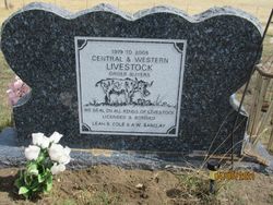
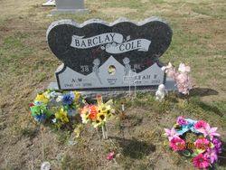
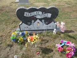
Leah Rita Currey Cole
| Birth | : | 21 Jan 1938 Kalispell, Flathead County, Montana, USA |
| Death | : | 22 Feb 2012 Jordan, Garfield County, Montana, USA |
| Burial | : | Pioneer Cemetery, Jordan, Garfield County, USA |
| Coordinate | : | 47.3244019, -106.9238968 |
| Description | : | Life Legacy Leah Rita Cole, age 74, of Jordan passed away on Wednesday, February 22, 2012 at her home in Jordan with her family by her side. Leah was born in Kalispell, Montana on January 21, 1938, the daughter of Claude and Rita (Kincaid) Currey. She grew up and attended schools in Jordan. Following her schooling, she worked with local sheep shearing crews and worked at local restaurants. In 1962, she purchased the family ranch which she operated until she sold the ranch in 2005. Leah also helped with the day to day operation of her husband Sandy Barclay's ranch. During... Read More |
frequently asked questions (FAQ):
-
Where is Leah Rita Currey Cole's memorial?
Leah Rita Currey Cole's memorial is located at: Pioneer Cemetery, Jordan, Garfield County, USA.
-
When did Leah Rita Currey Cole death?
Leah Rita Currey Cole death on 22 Feb 2012 in Jordan, Garfield County, Montana, USA
-
Where are the coordinates of the Leah Rita Currey Cole's memorial?
Latitude: 47.3244019
Longitude: -106.9238968
Family Members:
Parent

Spouse
Flowers:


Nearby Cemetories:
1. Pioneer Cemetery
Jordan, Garfield County, USA
Coordinate: 47.3244019, -106.9238968
2. Greenridge Cemetery
Jordan, Garfield County, USA
Coordinate: 47.3389015, -106.8946991
3. Hinther Cemetery
Garfield County, USA
Coordinate: 47.2685000, -107.0218000
4. Butte Creek Cemetery
Garfield County, USA
Coordinate: 47.4777985, -107.2341995
5. Steve Forks Cemetery
Garfield County, USA
Coordinate: 47.2627983, -107.3321991
6. Cohagen Cemetery
Cohagen, Garfield County, USA
Coordinate: 47.0772018, -106.6232986
7. Darnall-Armbruster-Hubbard Family Cemetery
Garfield County, USA
Coordinate: 47.6407000, -107.0645200
8. Neudorfer Cemetery
Jordan, Garfield County, USA
Coordinate: 47.2095000, -106.2772000
9. Hearts at Peace Cemetery
Brusett, Garfield County, USA
Coordinate: 47.5441900, -107.5399200
10. Wolf Cemetery
Garfield County, USA
Coordinate: 47.1528015, -107.5924988
11. Vanstel Cemetery
Rosebud County, USA
Coordinate: 46.7872009, -106.8942032
12. Haglunds Ritchie Cemetery
McCone County, USA
Coordinate: 47.3246994, -106.0639038
13. Biebers Cemetery
McCone County, USA
Coordinate: 47.2386100, -106.0348800
14. Biebers Cemetery
McCone County, USA
Coordinate: 47.2257600, -106.0220400
15. Watkins Cemetery
McCone County, USA
Coordinate: 47.1808014, -105.9811020
16. Coon Cemetery
Garfield County, USA
Coordinate: 47.3263790, -107.9323320
17. Gilfeather Cemetery
Benzien, Garfield County, USA
Coordinate: 47.2348310, -107.9476920
18. Fort Peck Cemetery
Valley County, USA
Coordinate: 48.0069008, -106.4599991
19. Rock Springs Cemetery
Rock Springs, Rosebud County, USA
Coordinate: 46.7847800, -106.1411500
20. Fort Peck Dam Disaster Memorial
Valley County, USA
Coordinate: 48.0083000, -106.4003000
21. Brockway Cemetery
McCone County, USA
Coordinate: 47.2963982, -105.7514038
22. Brost Cemetery
McCone County, USA
Coordinate: 47.2971992, -105.7457962
23. Galpin Cemetery
Valley County, USA
Coordinate: 48.0732994, -106.4692001
24. Sumatra Cemetery
Rosebud County, USA
Coordinate: 46.6136017, -107.5674973