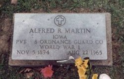
Alfred Raymond Martin
| Birth | : | 5 Nov 1894 Selma, Van Buren County, Iowa, USA |
| Death | : | 22 Aug 1965 Iowa City, Johnson County, Iowa, USA |
| Burial | : | St. Nicholas' Churchyard, Liverpool, Metropolitan Borough of Liverpool, England |
| Coordinate | : | 53.4069350, -2.9951480 |
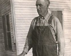
| Description | : | Alfred Raymond "Gundy" Martin, 70, Fairfield, Route 2, died Aug. 22, 1965 at the Veterans Hospital in Iowa City where he had been a patient since July 1. He was a retired Philco-Dexter employee. He was born Nov. 5, 1894 at Selma, the son of William C. and Florence E. Penn Martin. He was married to Pansy Lawrence Sept. 22, 1920. He was a veteran of World War I and a member of the American Legion. He is survived by two children; Mrs. Elizabeth Tomlinson and James L. Martin, both of Wilmington, Delaware. Also surviving are six grandchildren and the... Read More |
frequently asked questions (FAQ):
-
Where is Alfred Raymond Martin's memorial?
Alfred Raymond Martin's memorial is located at: St. Nicholas' Churchyard, Liverpool, Metropolitan Borough of Liverpool, England.
-
When did Alfred Raymond Martin death?
Alfred Raymond Martin death on 22 Aug 1965 in Iowa City, Johnson County, Iowa, USA
-
Where are the coordinates of the Alfred Raymond Martin's memorial?
Latitude: 53.4069350
Longitude: -2.9951480
Family Members:
Parent
Siblings
Flowers:
Nearby Cemetories:
1. St. Nicholas' Churchyard
Liverpool, Metropolitan Borough of Liverpool, England
Coordinate: 53.4069350, -2.9951480
2. Liverpool Naval Memorial
Liverpool, Metropolitan Borough of Liverpool, England
Coordinate: 53.4061220, -2.9981050
3. St. Paul's Churchyard
Liverpool, Metropolitan Borough of Liverpool, England
Coordinate: 53.4099460, -2.9919370
4. St. George's Churchyard
Liverpool, Metropolitan Borough of Liverpool, England
Coordinate: 53.4049700, -2.9901030
5. St. Peter's Churchyard
Liverpool, Metropolitan Borough of Liverpool, England
Coordinate: 53.4051290, -2.9844200
6. St. Thomas Churchyard
Liverpool, Metropolitan Borough of Liverpool, England
Coordinate: 53.4010330, -2.9861190
7. St. John's Garden
Liverpool, Metropolitan Borough of Liverpool, England
Coordinate: 53.4087890, -2.9810070
8. Friends Burial Ground (Defunct)
Liverpool, Metropolitan Borough of Liverpool, England
Coordinate: 53.4111670, -2.9795830
9. Roscoe Memorial Gardens
Liverpool, Metropolitan Borough of Liverpool, England
Coordinate: 53.4044040, -2.9762180
10. Holy Trinity Churchyard
Liverpool, Metropolitan Borough of Liverpool, England
Coordinate: 53.4117490, -2.9759560
11. St. Anne's Churchyard
Liverpool, Metropolitan Borough of Liverpool, England
Coordinate: 53.4149050, -2.9782840
12. St. Michaels Churchyard
Liverpool, Metropolitan Borough of Liverpool, England
Coordinate: 53.3976599, -2.9789353
13. St. Andrew’s Churchyard
Liverpool, Metropolitan Borough of Liverpool, England
Coordinate: 53.4029730, -2.9726820
14. St Philip Graveyard
Liverpool, Metropolitan Borough of Liverpool, England
Coordinate: 53.4019240, -2.9719920
15. St Martin-in-the-Fields Churchyard
Liverpool, Metropolitan Borough of Liverpool, England
Coordinate: 53.4210110, -2.9877860
16. Metropolitan Cathedral of Christ the King
Liverpool, Metropolitan Borough of Liverpool, England
Coordinate: 53.4052820, -2.9685940
17. Liverpool Cathedral
Liverpool, Metropolitan Borough of Liverpool, England
Coordinate: 53.3974310, -2.9731610
18. Brunswick Chapel
Liverpool, Metropolitan Borough of Liverpool, England
Coordinate: 53.4111280, -2.9675500
19. St Mary’s Parochial Cemetery
Liverpool, Metropolitan Borough of Liverpool, England
Coordinate: 53.4024370, -2.9672760
20. St. James Churchyard
Toxteth, Metropolitan Borough of Liverpool, England
Coordinate: 53.3943720, -2.9750688
21. St. Anthony's Churchyard
Liverpool, Metropolitan Borough of Liverpool, England
Coordinate: 53.4223190, -2.9815350
22. St James Garden Cemetery
Liverpool, Metropolitan Borough of Liverpool, England
Coordinate: 53.3960744, -2.9715005
23. Wesleyan Methodist Chapel Graveyard
Liverpool, Metropolitan Borough of Liverpool, England
Coordinate: 53.3940590, -2.9719160
24. St. Mary's Churchyard
Birkenhead, Metropolitan Borough of Wirral, England
Coordinate: 53.3895930, -3.0112520

