
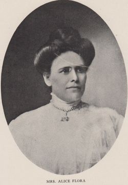
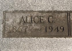
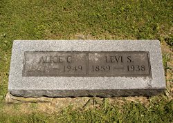


Alice C Waltemeyer Flora
| Birth | : | 11 Dec 1867 Haldane, Ogle County, Illinois, USA |
| Death | : | 18 Oct 1949 Marshalltown, Marshall County, Iowa, USA |
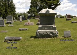
| Burial | : | Zeehan General Cemetery, Zeehan, West Coast Council, Australia |
| Coordinate | : | -41.8829930, 145.3149400 |
| Description | : | Alice came to Logan Township with her parents in 1868, when six months old. The Floras having no children of their own, had the opportunity to raise a foster daughter, Elva Kline Robinson. Elva was never adopted by the Floras because of her grandfather Peter Kline's wishes, wanting to keep the name Kline. She was a member of the Methodist Episcopal church at Rhodes. For close to 20 years she raised the Light Brahma chickens, then she began to raise full blooded Black Langshans chickens. She passed away at Deaconess Hospital. MARRIED: 26 Jan 1887, Bureau Co., IL FOSTER DAUGHTER: Elva Lois Kline Robinson, 18 Nov 1887 -... Read More |
frequently asked questions (FAQ):
-
Where is Alice C Waltemeyer Flora's memorial?
Alice C Waltemeyer Flora's memorial is located at: Zeehan General Cemetery, Zeehan, West Coast Council, Australia.
-
When did Alice C Waltemeyer Flora death?
Alice C Waltemeyer Flora death on 18 Oct 1949 in Marshalltown, Marshall County, Iowa, USA
-
Where are the coordinates of the Alice C Waltemeyer Flora's memorial?
Latitude: -41.8829930
Longitude: 145.3149400
Family Members:
Parent
Spouse
Siblings

Flowers:


Nearby Cemetories:
1. Zeehan General Cemetery
Zeehan, West Coast Council, Australia
Coordinate: -41.8829930, 145.3149400
2. Zeehan Pioneer Cemetery
Zeehan, West Coast Council, Australia
Coordinate: -41.8958600, 145.3467730
3. Williamsford-Rosebery Cemetery
Williamsford, West Coast Council, Australia
Coordinate: -41.7961920, 145.5232900
4. Tullah
Tullah, West Coast Council, Australia
Coordinate: -41.7440950, 145.6146170
5. Queenstown Pioneer Cemetery
Queenstown, West Coast Council, Australia
Coordinate: -42.0858800, 145.5494800
6. Queenstown Lyell Cemetery
Queenstown, West Coast Council, Australia
Coordinate: -42.0966300, 145.5366610
7. Strahan Cemetery
Strahan, West Coast Council, Australia
Coordinate: -42.1621150, 145.3273410
8. Linda Cemetery
Linda, West Coast Council, Australia
Coordinate: -42.0666656, 145.6000061
9. Corinna Cemetery
Corinna, Waratah-Wynyard Council, Australia
Coordinate: -41.6509770, 145.0783630
10. Waratah Lawn Cemetery
Waratah, Waratah-Wynyard Council, Australia
Coordinate: -41.4590340, 145.5212690
11. Waratah Pioneer Cemetery
Guildford Junction, Waratah-Wynyard Council, Australia
Coordinate: -41.4489490, 145.5709770
12. Lorinna Cemetery
Lorinna, Kentish Council, Australia
Coordinate: -41.5477800, 146.1345900
13. Henrietta Cemetery
Henrietta, Waratah-Wynyard Council, Australia
Coordinate: -41.1543686, 145.6882431
14. George Woodhouse Lookout
Riana, Central Coast Council, Australia
Coordinate: -41.2818184, 145.9948120
15. South Riana Uniting Church Cemetery
Central Coast Council, Australia
Coordinate: -41.2351280, 145.9792410
16. Wilmot Cemetery
Wilmot, Kentish Council, Australia
Coordinate: -41.3837350, 146.1871690
17. Ridgley General Cemetery
Ridgley, Burnie City, Australia
Coordinate: -41.1506070, 145.8236570
18. Claude Road Cemetery
Claude Road, Kentish Council, Australia
Coordinate: -41.4322840, 146.2871020
19. Mole Creek General and Lawn Cemetery
Mole Creek, Meander Valley Council, Australia
Coordinate: -41.5703200, 146.4055750
20. St. Andrew's Churchyard
Sprent, Central Coast Council, Australia
Coordinate: -41.2596490, 146.1593130
21. Lower Mount Hicks Cemetery
Lower Mount Hicks, Waratah-Wynyard Council, Australia
Coordinate: -41.0422810, 145.7384950
22. North Motton Methodist Cemetery
North Motton, Central Coast Council, Australia
Coordinate: -41.2091270, 146.1096290
23. Sheffield Cemetery
Sheffield, Kentish Council, Australia
Coordinate: -41.3726558, 146.3055161
24. St. John's Anglican Churchyard
North Motton, Central Coast Council, Australia
Coordinate: -41.2076090, 146.1088350