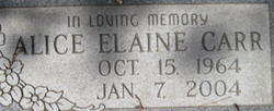
Alice Elaine Carr
| Birth | : | 15 Oct 1964 Bonners Ferry, Boundary County, Idaho, USA |
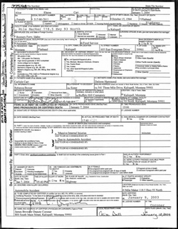
| Death | : | 7 Jan 2004 Flathead County, Montana, USA |
| Burial | : | Milnor Lake Cemetery, Troy, Lincoln County, USA |
| Coordinate | : | 48.4181150, -115.8259500 |
| Description | : | KALISPELL - A sport utility vehicle and a truck collided on U.S. 93 Wednesday night, killing a 39-year-old woman from Evergreen and injuring three other people. The Montana Highway Patrol identified the victim as Alice Carr, a passenger in the southbound SUV. Its driver lost control on the slick road and skidded broadside into the path of a northbound truck that struck the passenger side, the patrol said. The SUV's driver and two other passengers were hospitalized. The truck driver was not seriously hurt. |
frequently asked questions (FAQ):
-
Where is Alice Elaine Carr's memorial?
Alice Elaine Carr's memorial is located at: Milnor Lake Cemetery, Troy, Lincoln County, USA.
-
When did Alice Elaine Carr death?
Alice Elaine Carr death on 7 Jan 2004 in Flathead County, Montana, USA
-
Where are the coordinates of the Alice Elaine Carr's memorial?
Latitude: 48.4181150
Longitude: -115.8259500
Family Members:
Parent
Siblings
Flowers:
Nearby Cemetories:
1. Milnor Lake Cemetery
Troy, Lincoln County, USA
Coordinate: 48.4181150, -115.8259500
2. Larchwood Cemetery
Lincoln County, USA
Coordinate: 48.4178009, -115.8257980
3. Troy Cemetery
Troy, Lincoln County, USA
Coordinate: 48.4752330, -115.8992710
4. Winn Family Cemetery
Lincoln County, USA
Coordinate: 48.5488590, -115.9644710
5. Bull Lake Guest Ranch Cemetery
Troy, Lincoln County, USA
Coordinate: 48.2424940, -115.8275090
6. Libby Cemetery
Libby, Lincoln County, USA
Coordinate: 48.3893540, -115.5646380
7. Leonia Cemetery
Leonia, Boundary County, USA
Coordinate: 48.6161720, -116.0497860
8. Boulder Creek Cemetery
Boundary County, USA
Coordinate: 48.6194000, -116.0571976
9. Sylvanite Cemetery
Lincoln County, USA
Coordinate: 48.7210000, -115.8745000
10. Clark Fork Cemetery
Clark Fork, Bonner County, USA
Coordinate: 48.1610000, -116.1690000
11. Cloudledge Cemetery
East Hope, Bonner County, USA
Coordinate: 48.2345670, -116.2772340
12. Hope Cemetery
East Hope, Bonner County, USA
Coordinate: 48.2449989, -116.2966995
13. Owen Family Cemetery
East Hope, Bonner County, USA
Coordinate: 48.2160100, -116.2790200
14. Old Hope Cemetery
Hope, Bonner County, USA
Coordinate: 48.2530500, -116.3157300
15. Heron Cemetery
Heron, Sanders County, USA
Coordinate: 48.0613000, -115.9621000
16. Cabinet Cemetery
Bonner County, USA
Coordinate: 48.0826000, -116.0681000
17. Parker Family Cemetery
Boundary County, USA
Coordinate: 48.6665200, -116.2619200
18. Paradise Valley Cemetery
Bonners Ferry, Boundary County, USA
Coordinate: 48.6453018, -116.3080978
19. Gold Creek Cemetery
Bonner County, USA
Coordinate: 48.4000015, -116.4160995
20. Holy Myrrhbearers Orthodox Church Parish Cemetery
Bonners Ferry, Boundary County, USA
Coordinate: 48.6190260, -116.3598830
21. Grandview Cemetery
Bonners Ferry, Boundary County, USA
Coordinate: 48.6851300, -116.2932700
22. Pack River Cemetery
Bonner County, USA
Coordinate: 48.3675620, -116.4404120
23. McArthur Cemetery
Boundary County, USA
Coordinate: 48.5246000, -116.4350000
24. Noxon Cemetery
Noxon, Sanders County, USA
Coordinate: 47.9908295, -115.7822189


