
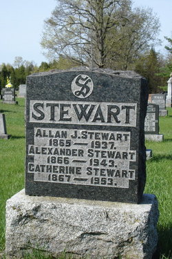
Allan J. Stewart
| Birth | : | 20 Jan 1865 Dalhousie Lake, Lanark County, Ontario, Canada |
| Death | : | 26 Oct 1937 McDonald Corners, Lanark County, Ontario, Canada |
| Burial | : | Greenwood Cemetery, Nisswa, Crow Wing County, USA |
| Coordinate | : | 46.5217000, -94.2803000 |
| Plot | : | 440 |
| Description | : | Son of Daniel Stewart & Mary McLean ------------------------------ Plot 440 : - Allan J. Stewart 1865-1937 - Alexander Stewart 1866-1943 - Catherine Stewart 1867-1953 - (all siblings) |
frequently asked questions (FAQ):
-
Where is Allan J. Stewart's memorial?
Allan J. Stewart's memorial is located at: Greenwood Cemetery, Nisswa, Crow Wing County, USA.
-
When did Allan J. Stewart death?
Allan J. Stewart death on 26 Oct 1937 in McDonald Corners, Lanark County, Ontario, Canada
-
Where are the coordinates of the Allan J. Stewart's memorial?
Latitude: 46.5217000
Longitude: -94.2803000
Family Members:
Parent

Siblings


Flowers:


Nearby Cemetories:
1. Greenwood Cemetery
Nisswa, Crow Wing County, USA
Coordinate: 46.5217000, -94.2803000
2. Lutheran Church of the Cross Memorial Garden
Nisswa, Crow Wing County, USA
Coordinate: 46.5011200, -94.2955600
3. Pineswood Cemetery
Lake Hubert, Crow Wing County, USA
Coordinate: 46.4964400, -94.2820200
4. Thorp-Heald Cemetery
Lake Hubert, Crow Wing County, USA
Coordinate: 46.5022000, -94.2537000
5. Living Savior Columbarium
Lake Shore, Cass County, USA
Coordinate: 46.5026450, -94.3535730
6. Lake Edward Cemetery
Crow Wing County, USA
Coordinate: 46.4981003, -94.2035980
7. Lake Shore Memorial Garden Cemetery
Cass County, USA
Coordinate: 46.4860760, -94.3767600
8. Pequot Lakes City Cemetery
Pequot Lakes, Crow Wing County, USA
Coordinate: 46.6022200, -94.3180600
9. Our Saviors Lutheran Cemetery
Pequot Lakes, Crow Wing County, USA
Coordinate: 46.6028000, -94.3167000
10. Pelican Woods Cemetery and Nature Trail
Breezy Point, Crow Wing County, USA
Coordinate: 46.6024500, -94.2205310
11. Stoney Brook Cemetery
Cass County, USA
Coordinate: 46.5725000, -94.4097000
12. Kedron Cemetery
Cass County, USA
Coordinate: 46.6022700, -94.3893300
13. Gravdahl Family Cemetery
Cass County, USA
Coordinate: 46.6173000, -94.3923100
14. Pleasant Hill Cemetery
Cass County, USA
Coordinate: 46.5436000, -94.4570500
15. Evergreen Cemetery
Merrifield, Crow Wing County, USA
Coordinate: 46.5180500, -94.0917500
16. Jenkins Cemetery
Jenkins, Crow Wing County, USA
Coordinate: 46.6542015, -94.3236008
17. Evergreen Memorial Gardens
Brainerd, Crow Wing County, USA
Coordinate: 46.4010010, -94.1740036
18. Saint Thomas of the Pines Cemetery
East Gull Lake, Cass County, USA
Coordinate: 46.3921300, -94.3809900
19. Mayo Brook Cemetery
Cass County, USA
Coordinate: 46.6156006, -94.4543991
20. Mission Cemetery
Mission, Crow Wing County, USA
Coordinate: 46.5588989, -94.0511017
21. Evergreen Cemetery
Brainerd, Crow Wing County, USA
Coordinate: 46.3708000, -94.1859000
22. Saint Pauls Episcopal Church Columbarium
Brainerd, Crow Wing County, USA
Coordinate: 46.3604205, -94.1988906
23. Pinewood Cemetery
Crosslake, Crow Wing County, USA
Coordinate: 46.6464005, -94.1089020
24. Baxter Cemetery
Baxter, Crow Wing County, USA
Coordinate: 46.3455600, -94.2855600