
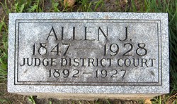
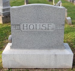
Allen J. House
| Birth | : | 12 Jan 1847 Brantford, Brant County Municipality, Ontario, Canada |
| Death | : | 6 Sep 1928 Maquoketa, Jackson County, Iowa, USA |
| Burial | : | Chevington Cemetery, Alnwick, Northumberland Unitary Authority, England |
| Coordinate | : | 55.2905270, -1.6148670 |
| Description | : | Judge of the Iowa District Court, 1892-1927. Husband of Emma House. Bio of Allen J. House: Allen J. House was born near Brantford, Ontario, Canada, January 12, 1847, and died in Maquoketa, Iowa, September 6, 1928. When fourteen years of age, owing to his parents large family, he left home to earn his own living. Two years later, in 1863, he arrived at Maquoketa to make his home with relatives. Here he engaged in farm work during summers and attended public school in Maquoketa in winters. In 1866, he lost an arm in a mowing machine accident. The following winter he attended the... Read More |
frequently asked questions (FAQ):
-
Where is Allen J. House's memorial?
Allen J. House's memorial is located at: Chevington Cemetery, Alnwick, Northumberland Unitary Authority, England.
-
When did Allen J. House death?
Allen J. House death on 6 Sep 1928 in Maquoketa, Jackson County, Iowa, USA
-
Where are the coordinates of the Allen J. House's memorial?
Latitude: 55.2905270
Longitude: -1.6148670
Family Members:
Spouse

Flowers:


Nearby Cemetories:
1. Chevington Cemetery
Alnwick, Northumberland Unitary Authority, England
Coordinate: 55.2905270, -1.6148670
2. St. John the Divine Churchyard
Acklington, Northumberland Unitary Authority, England
Coordinate: 55.3106000, -1.6435000
3. Amble West Cemetery
Amble, Northumberland Unitary Authority, England
Coordinate: 55.3311820, -1.5922950
4. Amble East Cemetery
Amble, Northumberland Unitary Authority, England
Coordinate: 55.3333190, -1.5696400
5. Felton Cemetery
Felton, Northumberland Unitary Authority, England
Coordinate: 55.3020920, -1.7118410
6. Saint Bartholomew’s Churchyard
Cresswell, Northumberland Unitary Authority, England
Coordinate: 55.2331200, -1.5444900
7. Saint Helen’s Churchyard
Longhorsley, Northumberland Unitary Authority, England
Coordinate: 55.2432500, -1.7588200
8. St John The Baptist Churchyard
Alnmouth, Northumberland Unitary Authority, England
Coordinate: 55.3882090, -1.6124020
9. Lynemouth Cemetery
Lynemouth, Northumberland Unitary Authority, England
Coordinate: 55.2031759, -1.5361996
10. Saint John's Churchyard
Longhirst, Northumberland Unitary Authority, England
Coordinate: 55.1936200, -1.6474840
11. St Cuthbert Churchyard
Hebron, Northumberland Unitary Authority, England
Coordinate: 55.2023450, -1.6963700
12. Longframlington Church Cemetery Extension
Longframlington, Northumberland Unitary Authority, England
Coordinate: 55.3014700, -1.7950600
13. St Mary the Virgin Churchyard
Longframlington, Northumberland Unitary Authority, England
Coordinate: 55.3028950, -1.7952920
14. Alnmouth Cemetery
Alnmouth, Northumberland Unitary Authority, England
Coordinate: 55.3951400, -1.6064100
15. Longframlington Cemetery
Longframlington, Northumberland Unitary Authority, England
Coordinate: 55.3085440, -1.8003926
16. St. Mary The Virgin Churchyard
Lesbury, Northumberland Unitary Authority, England
Coordinate: 55.3986820, -1.6277570
17. Saint Aidens Churchyard
Ashington, Northumberland Unitary Authority, England
Coordinate: 55.1826900, -1.5781400
18. Brinkburn Priory
Brinkburn, Northumberland Unitary Authority, England
Coordinate: 55.2788120, -1.8191170
19. Brinkburn Priory and Manor House
Longframlington, Northumberland Unitary Authority, England
Coordinate: 55.2789620, -1.8194090
20. St Andrew's Churchyard
Bothal, Northumberland Unitary Authority, England
Coordinate: 55.1731340, -1.6205890
21. Fairmoor Cemetery
Morpeth, Northumberland Unitary Authority, England
Coordinate: 55.1861980, -1.7163260
22. Alnwick Cemetery
Alnwick, Northumberland Unitary Authority, England
Coordinate: 55.4037170, -1.6919940
23. North Seaton Cemetery
Ashington, Northumberland Unitary Authority, England
Coordinate: 55.1669770, -1.5575500
24. St Peter Churchyard
Cambois, Northumberland Unitary Authority, England
Coordinate: 55.1615300, -1.5604100