
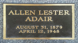
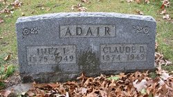
Allen Lester Adair
| Birth | : | 31 Aug 1879 Shell Rock, Butler County, Iowa, USA |
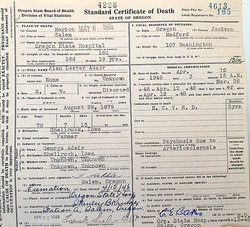
| Death | : | 12 Apr 1948 Salem, Marion County, Oregon, USA |
| Burial | : | Riverside Cemetery, Shell Rock, Butler County, USA |
| Coordinate | : | 42.7126600, -92.5874500 |
| Description | : | Allen's cremated remains were not initially taken after his death and were available at the Oregon State Hospital to anyone who is related. They were claimed his grand niece in 2014 and in November 2014 they were scattered on the farm where Allen was born in the area where the house was before it was taken down. His name and birth and death dates are on a plaque to be attached to the back of his father's tombstone in Riverview Cemetery in Shell Rock, Iowa. According to family records Allen's first name is spelled ALLEN, although he signed his name... Read More |
frequently asked questions (FAQ):
-
Where is Allen Lester Adair's memorial?
Allen Lester Adair's memorial is located at: Riverside Cemetery, Shell Rock, Butler County, USA.
-
When did Allen Lester Adair death?
Allen Lester Adair death on 12 Apr 1948 in Salem, Marion County, Oregon, USA
-
Where are the coordinates of the Allen Lester Adair's memorial?
Latitude: 42.7126600
Longitude: -92.5874500
Family Members:
Parent
Spouse

Siblings
Children
Flowers:

Rest in Peace Alan Adair
Left by Anonymous on 09 Dec 2011

Rest in peace.
Left by Anonymous on 02 Mar 2014

Sorry you were estranged from your family, Allen. You are not forgotten! Remembered at www.debmorrow51.com with the rest of the Adairs! Rest in Peace
Left by Anonymous on 21 Oct 2016

Left by Anonymous on 14 May 2017

Left by Anonymous on 04 Sep 2019

Left by Anonymous on 04 May 2020


Nearby Cemetories:
1. Riverside Cemetery
Shell Rock, Butler County, USA
Coordinate: 42.7126600, -92.5874500
2. Lowell Cemetery
Clarksville, Butler County, USA
Coordinate: 42.7578011, -92.6346970
3. West Point Cemetery
Bremer County, USA
Coordinate: 42.6680984, -92.5346985
4. Pilot Mound Cemetery
Janesville, Bremer County, USA
Coordinate: 42.6856003, -92.5141983
5. Butler County Poor Farm Cemetery
Allison, Butler County, USA
Coordinate: 42.7400800, -92.6635000
6. Antioch Cemetery
Clarksville, Butler County, USA
Coordinate: 42.7740100, -92.6132900
7. Spring Lake Cemetery
Waverly, Bremer County, USA
Coordinate: 42.7742004, -92.5147018
8. Old Town Cemetery
Clarksville, Butler County, USA
Coordinate: 42.7742004, -92.6622009
9. Harlington Cemetery
Waverly, Bremer County, USA
Coordinate: 42.7158012, -92.4721985
10. Finchford Cemetery
Finchford, Black Hawk County, USA
Coordinate: 42.6276400, -92.5398800
11. Saint Marys Cemetery
Waverly, Bremer County, USA
Coordinate: 42.7275009, -92.4563980
12. Peace United Church of Christ Cemetery
Waverly, Bremer County, USA
Coordinate: 42.7192630, -92.4543880
13. Saint Pauls Lutheran Cemetery
Waverly, Bremer County, USA
Coordinate: 42.7188988, -92.4539032
14. Saint Josephs Cemetery
Waverly, Bremer County, USA
Coordinate: 42.7200012, -92.4539032
15. Lynwood Cemetery
Clarksville, Butler County, USA
Coordinate: 42.7832985, -92.6810989
16. Coster Cemetery
Allison, Butler County, USA
Coordinate: 42.6749600, -92.7122700
17. Andrews Cemetery
Waverly, Bremer County, USA
Coordinate: 42.7771988, -92.4772034
18. Newell Cemetery
Black Hawk County, USA
Coordinate: 42.6333008, -92.4903030
19. Oakland Cemetery
Janesville, Bremer County, USA
Coordinate: 42.6558930, -92.4559700
20. Town Line Cemetery
Waverly, Bremer County, USA
Coordinate: 42.7443650, -92.4353380
21. Pleasant Valley Cemetery
Clarksville, Butler County, USA
Coordinate: 42.8332000, -92.6148000
22. Gerholdt Cemetery
Black Hawk County, USA
Coordinate: 42.6009010, -92.5190130
23. New Albion Cemetery
Butler County, USA
Coordinate: 42.6427994, -92.7416992
24. Rude Cemetery
New Hartford, Butler County, USA
Coordinate: 42.5788080, -92.5647070