
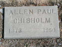
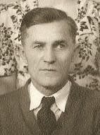
Allen Paul Chisholm
| Birth | : | 13 Aug 1873 Mille Lacs County, Minnesota, USA |
| Death | : | 8 Jun 1950 Sunnyside, Yakima County, Washington, USA |
| Burial | : | Cayucos-Morro Bay District Cemetery, Cayucos, San Luis Obispo County, USA |
| Coordinate | : | 35.4371986, -120.8850021 |
| Description | : | Washington Death Certificate Name: Allen Paul Chisholm Death Date: 08 Jun 1950 Death Place: Sunnyside, Yakima, Washington Gender: Male Age at Death: 77 years Estimated Birth Year: 1873 Film Number: 2032911 Digital GS Number: 4223297 Image Number: 947 Volume/Page/Certificate Number: rn43, sfn11418 |
frequently asked questions (FAQ):
-
Where is Allen Paul Chisholm's memorial?
Allen Paul Chisholm's memorial is located at: Cayucos-Morro Bay District Cemetery, Cayucos, San Luis Obispo County, USA.
-
When did Allen Paul Chisholm death?
Allen Paul Chisholm death on 8 Jun 1950 in Sunnyside, Yakima County, Washington, USA
-
Where are the coordinates of the Allen Paul Chisholm's memorial?
Latitude: 35.4371986
Longitude: -120.8850021
Family Members:
Parent
Spouse
Siblings

Children
Flowers:


Nearby Cemetories:
1. St. Peter’s By-the-Sea Episcopal Church Memo
Morro Bay, San Luis Obispo County, USA
Coordinate: 35.3628700, -120.8467400
2. Canet Cemetery
San Luis Obispo County, USA
Coordinate: 35.3522840, -120.7901660
3. Adelaida Cemetery
Adelaida, San Luis Obispo County, USA
Coordinate: 35.5632085, -120.8956170
4. Los Osos Valley Memorial Park
Los Osos, San Luis Obispo County, USA
Coordinate: 35.3053017, -120.8011017
5. Willow Creek Mennonite Cemetery
Wilson Corner, San Luis Obispo County, USA
Coordinate: 35.5890410, -120.8215860
6. Chapel of the Roses Cemetery
Atascadero, San Luis Obispo County, USA
Coordinate: 35.5027340, -120.6881430
7. Atascadero Pine Mountain Cemetery
Atascadero, San Luis Obispo County, USA
Coordinate: 35.4960835, -120.6565582
8. Saint Pauls Episcopal Church Memorial Garden
Cambria, San Luis Obispo County, USA
Coordinate: 35.5575200, -121.0757200
9. Templeton Cemetery
Templeton, San Luis Obispo County, USA
Coordinate: 35.5714455, -120.7022095
10. Dove Cemetery
San Luis Obispo County, USA
Coordinate: 35.4482231, -120.6344299
11. Santa Rosa Cemetery
Cambria, San Luis Obispo County, USA
Coordinate: 35.5662900, -121.0809300
12. Cambria Cemetery
Cambria, San Luis Obispo County, USA
Coordinate: 35.5746994, -121.0922012
13. Adelaida Cemetery
San Luis Obispo County, USA
Coordinate: 35.6563988, -120.8728027
14. Porte Family Cemetery
San Simeon, San Luis Obispo County, USA
Coordinate: 35.6376400, -121.0379800
15. Mission San Luis Obispo Cemetery
San Luis Obispo, San Luis Obispo County, USA
Coordinate: 35.2806600, -120.6645200
16. Old Mission Cemetery
San Luis Obispo, San Luis Obispo County, USA
Coordinate: 35.2670660, -120.6692150
17. San Luis Cemetery
San Luis Obispo, San Luis Obispo County, USA
Coordinate: 35.2644192, -120.6712830
18. Santa Margarita Cemetery
Santa Margarita, San Luis Obispo County, USA
Coordinate: 35.3913994, -120.5880966
19. Saint James Episcopal Church Inurnment Garden
Paso Robles, San Luis Obispo County, USA
Coordinate: 35.6283460, -120.6929780
20. Paso Robles District Cemetery
Paso Robles, San Luis Obispo County, USA
Coordinate: 35.6424700, -120.7035000
21. San Marcos Mennonite Cemetery
San Luis Obispo County, USA
Coordinate: 35.6874570, -120.7995160
22. Creston Cemetery
Creston, San Luis Obispo County, USA
Coordinate: 35.5328640, -120.5121450
23. Estrella Adobe Cemetery
Paso Robles, San Luis Obispo County, USA
Coordinate: 35.6975080, -120.6399460
24. San Miguel District Cemetery
San Miguel, San Luis Obispo County, USA
Coordinate: 35.7392006, -120.7013550